
Cycle Tour From Tarifa to Amsterdam
Travel report: Transeuropa Part 1
Actions
![]()
Please wait - map data are loading
Added on 02 Aug 2015,
last edited by TheDoc on 29 Aug 2015
Actions
Cycle route metrics
planned
ridden
Total distance in km
3.629
3.983
Cumulative elevation gain in m
26.163
31.398
Avg. slope uphill in %
0,72
0,79
Cumulative elevation loss in m
26.158
31.520
Information about rights to the gps-track data | |
|---|---|
Rights owner | |
Rights characteristic / license | by-sa: CREATIVE COMMONS Attribution-ShareAlike |
Link to the description of the license | |
GPX file uploaded | by TheDoc on 03 Aug 2015
|
Track points in total
30.756
34.371
Track points per km (avg)
8
9
Start/endpoint
Start location
Tarifa, Andalusia, ES (1 m NHN)
End location
Amsterdam, North Holland, NL (6 m NHN)
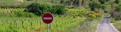
Character
Soweit möglich auf asphaltierten Radwegen oder Seitenstraßen
So wenig Steigung, dass es mit den Packtaschen ohne schieben geht
Übernachtung nur in Hotels
Tagesetappen 60-100km
Information about copyright | |
|---|---|
Rights characteristic / license | by-sa: CREATIVE COMMONS Attribution-ShareAlike |
Link to the description of the license | |
taken over / edited on | 13 Aug 2015
|
taken over / edited by |
|
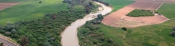
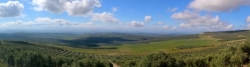
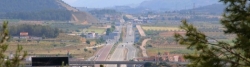
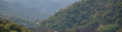
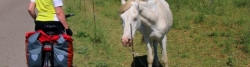
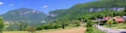
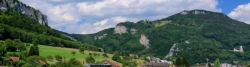
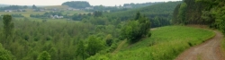
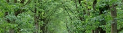
Landscape
Information about copyright | |
|---|---|
Rights characteristic / license | by-sa: CREATIVE COMMONS Attribution-ShareAlike |
Link to the description of the license | |
taken over / edited on | 13 Aug 2015
|
taken over / edited by |
|
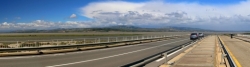
Travel to and from ...
Anreise: Flugzeug nach Malaga + Bus nach Tarifa
Rückreise: Zug von Amsterdam
Sources of information
http://www.biroto.eu
http://www.bahntrassenradeln.de
http://www.bikemap.net
https://www.velomap.org/
http://www.eurovelo.org/
http://en.viarhona.com/
Stages
69 km
Tarifa » Conil de la Frontera
82 km
Conil de la Frontera - Sanlucar de Barrameda
78 km
Sanlucar de Barrameda - Los Palacios y Villafranca
56 km
Los Palacios y Villafranca - Carmona
54 km
Carmona - Palma del Rio
60 km
Palma del Rio - Cordoba
73 km
Cordoba - Marmolejo
80 km
Marmolejo - Baeza
84 km
Baeza - Puente de Génave
53 km
Puente de Génave - Alcaraz
80 km
Alcaraz - Albacete
79 km
Albacete - Almansa
70 km
Almansa - Xàtiva
76 km
Xàtiva - Valencia
95 km
Valencia - Benicàssim
97 km
Benicàssim - Sant Carles de la Ràpita
99 km
Sant Carles de la Ràpita - Tarragona
95 km
Tarragona - Barcelona
87 km
Barcelona - Sils
69 km
Sils - Pont de Molins
50 km
Pont de Molins - Perpignan
77 km
Perpignan - Narbonne
81 km
Narbonne - Sète
87 km
Sète - Saint-Gilles
57 km
Saint-Gilles - Avignon
73 km
Avignon - Pierrelatte
59 km
Pierrelatte - Le Pouzin
78 km
Le Pouzin - Saint-Rambert-dʹAlbon
76 km
Saint-Rambert-dʹAlbon - Lyon
77 km
Porcieu-Amblagnieo - Chanaz
76 km
Chanaz - Genf
89 km
Genf - Yverdon-Les-Bains
40 km
Yverdon-Les-Bains - Neuchâtel
86 km
Neuchâtel - Balsthal
46 km
Balsthal - Basel
76 km
Basel - Colmar
23 km
Colmar - Ribeauville
74 km
Ribeauville - Straßburg
71 km
Straßburg - Niderviller
88 km
Niderviller - Nancy
73 km
Nancy - Metz
64 km
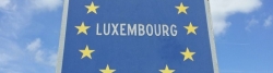
Metz - Luxembourg
90 km
Luxembourg - Bastogne
42 km
Bastogne - Nassogne
75 km
Nassogne - Namur
60 km
Namur - Leuven
63 km
Leuven - Antwerpen
75 km
Antwerpen - Zevenbergen
66 km
Zevenbergen - Gouda
Beds4Cyclists, worth visiting and infrastructure
Name and address
Latitude / Longitude
Phone
Fax
Mobile
Type of accommodation
Rating for cyclists
Route km
Dist. to route
Elevation
1 km
0,5 km
13 m
68 km
0,0 km
16 m
69 km
2,1 km
20 m
69 km
0,1 km
50 m
Information about copyright | |
|---|---|
Rights owner | |
Rights characteristic / license | cc0: Public Domain no Rights reserved |
Link to the description of the license | |
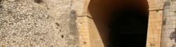
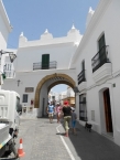
Image taken over from | https://commons.wikimedia.org/wiki/File:Das_Stadttor_von_Conil.JPG |
Image has been uploaded | by biroto-Redaktion on 26 Mar 2018
|
Information about copyright | |
|---|---|
Rights owner | |
Rights characteristic / license | cc0: Public Domain no Rights reserved |
Link to the description of the license | |
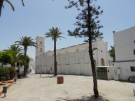
Image taken over from | https://commons.wikimedia.org/wiki/File:Sta_Catalina_Conil.JPG |
Image has been uploaded | by biroto-Redaktion on 26 Mar 2018
|
Information about copyright | |
|---|---|
Rights owner | https://commons.wikimedia.org/w/index.php?title=User:Giel358 |
Rights characteristic / license | by-sa: CREATIVE COMMONS Attribution-ShareAlike |
Link to the description of the license | |
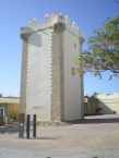
Image taken over from | https://commons.wikimedia.org/wiki/File:Conil_de_la_Frontera_(Torre_Guzman).jpg |
Image has been uploaded | by biroto-Redaktion on 27 Mar 2018
|
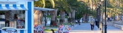
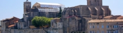
Conil de la Frontera ist eine spanische Stadt in der Provinz Cádiz ![]() an der Costa de la Luz mit ca. 21.000 Einwohnern. Dazu kommen in den Sommermonaten bis zu 80.000 Touristen.
an der Costa de la Luz mit ca. 21.000 Einwohnern. Dazu kommen in den Sommermonaten bis zu 80.000 Touristen.
Hintergrund
Conil ist einerseits eines der "weißen Dörfer", die an der Ruta de los Pueblos Blancos liegen, andererseits ein belebter Badeort an der Costa de la Luz, dessen Einwohnerzahl durch Tourismus zur Saison auf das Vierfache anwächst. Im Gegensatz zu den großen Hotelanlagen im Bereich von Novo Sancti Petri südlich von Cádiz ist die Infrastruktur hier jedoch noch weitgehend familiär und oft ländlich geprägt, selbst wenn an den Ortsrändern Apartmentanlagen wachsen, die hier jedoch einzeln vermietet werden. Der historische Ortskern ist nach wie vor sehenswert, auch wenn das touristisch-gastronomische Angebot deutliche Überhand gewonnen hat.
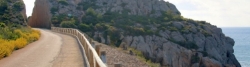
Im nahen Umland gibt es umfangreiche Möglichkeiten für ländliches Wohnen (Turismo rural), besonders auch für Pferdeliebhaber. Die Verschiedenheit der Strände in der Bucht von Conil in einem Spektrum von einsamen Badebuchten unter steinigen Steilküsten bis zum breiten Sandstrand setzen einen deutlichen Kontrapunkt zum Massentourismus und machen den Ort angesichts seiner guten Verkehrsanbindung zu einer hervorragenden Alternative für Individualtouristen in der Provinz Cadiz.
Die Reste einer phönizischen Nekropolis belegen, dass der Ort seit etwa 1.000 v. Chr. besiedelt war. Einige Quellen bringen Conil auch mit der späteren, römischen Stadt Mercablum in Zusammenhang. Einstmals waren der Haupterwerbszweige der Thunfischfang (Almadraba) und die Landwirtschaft, heute ist es wie in anderen Orten an der Costa de la Luz der Tourismus. Fischfang hat heute nur noch geringfügige Bedeutung. Landwirtschaftlich steht der Ackerbau im Vordergrund, allerdings gibt es auch etwas Rinderzucht.
Sehenswürdigkeiten
- Wie in allen weissen Dörfern Andalusiens ist auch hier die ⊙Altstadt als Ensemble zu betrachten und in einem Spaziergang einfach zu erkunden. Die weitgehend gastronomische und touristische Nutzung wird Puristen im Vergleich zu anderen maurischen Vierteln Andalusiens eher enttäuschen, zu einem gemütlichen Einkaufsbummel lädt sie allemal ein.
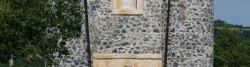
- Die Arbeiten zum Bau der Stadtmauer wurden vermutlich 1502 vom Herzog Juan de Guzmán beauftragt. Wegen der Verwendung mangelhafter Materialien stürzte aber schon damals ein Teil alsbald wieder ein. Daher ist im Wesentlichen nur noch die ⊙Puerta de la Villa, ehemals Puerta de Vejer, am oberen Ende der Altstadt erhalten.
- Reste einer phönizischen Nekropolis
- Der gut erhaltene und mehrfach restaurierte Aussichtsturm ⊙Torre de Guzmán ist neben einiger Mauerreste und Resten des ehemaligen Untergeschosses das letzte Überbleibsel des hier 1295 von Alonso Pérez de Guzmán "El Bueno" errichteten Castillo. Der 17,5 m hohe Turm dominiert den Hauptplatz an der Pfarrkirche Santa Catalina. Durch die mächtigen Zinnen am Dach genießt man eine prächtige Aussicht (Eintritt frei).
- Im Inneren befindet sich auch das auf Privatinitiative eingerichtete ⊙ Museo de Raíces Conileñas, Plaza Sta. Catalina, Nº 9. ☎ +34 956 440501. In vier Sälen werden über Fotos und Ausstellungsstücke die conilener Lebensverhältnisse im historischen Verlauf volkskundlich dargestellt. Geöffnet: Di-So 11:00-13:00, 21:00-23:00, Dez-Mrz über Tourismusbüro erfragen. Preis: Spenden erbeten.
- Daran anschließend die ehemalige Thunfischfabrik La Chanca, deren Gemäuer ursprünglich aus dem 16. Jhd. stammen. Hinter den massiven Mauern aus Muschelkalk wurde mehrfach umgebaut und restauriert. Seine Bedeutung ist mehr ethnologischer Natur, als hier bis zur Mitte des letzten Jahrhunderts tatsächlich Conils Lebenszentrum zu finden war.
- Der Wachturm Torre Castilnovo am südlichen Ende des Stadtstrandes ist heutzutage kaum mehr als eine Landmarke. Erbaut im 16. Jhd, vermutlich auch zur Überwachung der Thunfischströme, wurde er bereits 1755 durch ein Seebeben stark zerstört und 1995 in den heutigen Zustand restauriert.
- Auch der markante Leuchtturm auf dem Torre de Roche am Nordende der Bucht stammt ursprünglich aus dem 16. Jhd. und war ebenfalls Teil einer die ganze Küste umspannenden Warnanlage vor Angriffen von Meeresseite. Heute ist er ein beliebter Aussichtspunkt, von dem aus bei günstigen Konstellationen Sonnenuntergang über dem Atlantik und Mondaufgang über Conil fast gleichzeitig beobachtet werden kann.
- In Conil und Umgebung sind noch einige historische Holzöfen (Hornos) vorhanden, die gemeinschaftlicher Nutzung zum Brotbacken zugedacht waren, aber schwer zu finden sind.
Information about copyright | |
|---|---|
Rights characteristic / license | by-sa: CREATIVE COMMONS Attribution-ShareAlike |
Link to the description of the license | |
Input taken over from: |
Wikivoyage-Bearbeiter, 'Conil de la Frontera', Wikivoyage, Freie Reiseinformationen rund um die Welt, 28. Januar 2018, 17:57 UTC, <https://de.wikivoyage.org/w/index.php?title=Conil_de_la_Frontera&oldid=1075381> [abgerufen am 26. März 2018] |
taken over / edited on | 26 Mar 2018
|
taken over / edited by |
|
151 km
0,1 km
12 m
![]()