
Cycle Tour Iron Curtain Tour, part 3 Gdynia-Aš
Dag/day 23: Walkenried-Hohengandern
![]()
Please wait - map data are loading
Added on 14 Jun 2023
last edited by Ottocolor on 31 Jul 2023
Cycle route metrics
ridden
Total distance in km
81
Cumulative elevation gain in m
1.189
Avg. slope uphill in %
1,47
Cumulative elevation loss in m
1.252
Min. height
177
Max. height
345
Information about rights to the gps-track data | |
|---|---|
Rights owner | |
Rights characteristic / license | cc0: Public Domain no Rights reserved |
Link to the description of the license | |
GPX file uploaded | by Ottocolor on 15 Jun 2023
|
Track points in total
1.427
Track points per km (avg)
18
Start/endpoint
Start location
Walkenried, NI, DE (278 m NHN)
End location
Hohengandern, TH, DE (215 m NHN)
ridden on
31 May 2023
Weather
Sunny and hot, on the climbs definetely TOO hot. A few hazy clouds. Easterly winds, so a tailwind today.
Slope Gradient Distribution
Remarks
I had to shoren today's stage due to the many climbs and a flat tyre, so I made it to my stagegoal only the day after on the planned restday.
Travel report
Information about copyright | |
|---|---|
Rights owner | |
Rights characteristic / license | by-sa: CREATIVE COMMONS Attribution-ShareAlike |
Link to the description of the license | |
Image has been uploaded | by Ottocolor on 31 Jul 2023
|
Information about copyright | |
|---|---|
Rights owner | |
Rights characteristic / license | by-sa: CREATIVE COMMONS Attribution-ShareAlike |
Link to the description of the license | |
Image has been uploaded | by Ottocolor on 31 Jul 2023
|
Information about copyright | |
|---|---|
Rights owner | |
Rights characteristic / license | by-sa: CREATIVE COMMONS Attribution-ShareAlike |
Link to the description of the license | |
Image has been uploaded | by Ottocolor on 31 Jul 2023
|
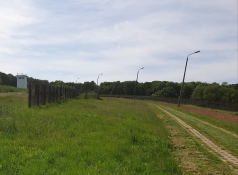
The next day the Harz was behind me and I cycled into Eichsfeld. But this district was only a little easier, because the roads still went up and down all day, mostly on nice little paths and roads through nature, but progress did indeed demand some work today. In addition, I had planned a long section on the hated patrol road with perforated concrete slabs, which I categorically opted out. It cost a rather long detour, which again involved steep climbs on only slightly better roads. Progress was slow.
After a dangerous road crossing, I reached the border museum at Teistungen, but drove past. There were, however, quite a few outdoor boards dealing with the border facilities, which I endulged in. And then I waffled with some other cyclists, so time passed and there were still 50 km to the finish in Wahlhausen. I gradually realized, not least when a particularly steep uphill had to be climbed, that the rest day the following day would be turned into a short stage, meaning that I found an emergency accommodation along the way. This was made totally sure, when my front wheel was suddenly flat. And the air pump was missing! It must have rattled out of the frame somewhere, probably in the Harz on a bad path. A kind woman working in her garden was my rescue. In addition, my rubber glue had dried completely. But she could also helped with that through her husband, who was a cycling enthusiast, and who came rolling on his recumbent bike soon after. That was very lucky indeed.
So when I reached Arenshausen, about 20 km before my planned finish line, I looked around for a night's accommodation using Google Maps and "eye ball mark one". But there was no contact and the town seemed completely dead. A couple just arrived home in their car and stated that the neighboring town of Hohengandern had an inn, which might be open. But again everything looked closed there. Well, I sat down next to some winos at a petrol station and drank some pop. I didn't dare drink beer if I had to bite the sour apple and cycle all the way to Wahlhausen. With the hills that were waiting here that would have been unwise. I attracted their attention and one asked if I needed a bed to sleep. And rang a guy in a pension, who was willing to accept me. Kai was a tenant himself, so the €50 he pocketed in cash were not settled anywhere. And Kai was a super nice fellow. He even provided me with free cakes for my handlebar bag.
Information about copyright | |
|---|---|
Rights characteristic / license | by-sa: CREATIVE COMMONS Attribution-ShareAlike |
Link to the description of the license | |
taken over / edited on | 31 Jul 2023
|
taken over / edited by |
|