
Cycle Tour Iron Curtain Tour, part 3 Gdynia-Aš
Dag/day 32: Kronach-Lichtenberg
![]()
Please wait - map data are loading
Added on 14 Jun 2023
last edited by Ottocolor on 04 Aug 2023
Cycle route metrics
ridden
Total distance in km
91
Cumulative elevation gain in m
1.451
Avg. slope uphill in %
1,59
Cumulative elevation loss in m
1.226
Min. height
302
Max. height
735
Information about rights to the gps-track data | |
|---|---|
Rights owner | |
Rights characteristic / license | cc0: Public Domain no Rights reserved |
Link to the description of the license | |
GPX file uploaded | by Ottocolor on 15 Jun 2023
|
Track points in total
1.583
Track points per km (avg)
17
Start/endpoint
Start location
Kronach, BY, DE (337 m NHN)
End location
Lichtenberg, BY, DE (562 m NHN)
ridden on
09 Jun 2023
Weather
Hot and sunny all day. Insignificant winds.
Slope Gradient Distribution
Travel report
Information about copyright | |
|---|---|
Rights owner | |
Rights characteristic / license | by-sa: CREATIVE COMMONS Attribution-ShareAlike |
Link to the description of the license | |
Image has been uploaded | by Ottocolor on 04 Aug 2023
|
Information about copyright | |
|---|---|
Rights owner | |
Rights characteristic / license | by-sa: CREATIVE COMMONS Attribution-ShareAlike |
Link to the description of the license | |
Image has been uploaded | by Ottocolor on 04 Aug 2023
|
Information about copyright | |
|---|---|
Rights owner | |
Rights characteristic / license | by-sa: CREATIVE COMMONS Attribution-ShareAlike |
Link to the description of the license | |
Image has been uploaded | by Ottocolor on 04 Aug 2023
|
Information about copyright | |
|---|---|
Rights owner | |
Rights characteristic / license | by-sa: CREATIVE COMMONS Attribution-ShareAlike |
Link to the description of the license | |
Image has been uploaded | by Ottocolor on 04 Aug 2023
|
Today, the penultimate stage to Lichtenberg was on the programme, and it turned out to be challenging. But not on the first half. I went up slowly but not at all steep, and the scenery was beautiful in lush river valleys.
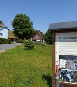
In Kleintettau I made a stop. The village is characterized by its glass industry. At a baker I had an ice coffee in the shade and enjoyed life. Soon after, I had lunch at a special place on the former border. A number of houses, located in Thuringia, had always had poor connections to their hinterland, but good connections to Kleintettau in Bavaria. When the border came, the inhabitants were initially isolated, but were then allowed to continue working in the glass factory and received their wages in D-Mark. It was a kind of hole in the iron curtain. Only in 1976 the border was finally moved, so that the residents came to belong to Bavaria and,order had been restored.
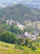
Shortly afterwards it dawned on me how high up in the terrain I had moved. A group of young people by their cars had stopped at a vantage point down towards Lauenstein castle. It looked really far down. The boys took a few good pictures of me. They thought it was crazy that I had cycled all the way up there. A girl was dressed as if she was going to a disco. Very ill-dressed out here in nature. As I said, I didn't feel I had ascended that much. But my GPS altimeter read over 700 meters. And the descent to Lauenstein was wild-wild. And with many hairpin turns. So my hydraulic disc brakes went into overtime.
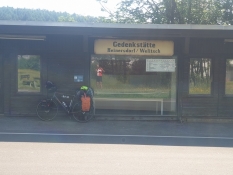
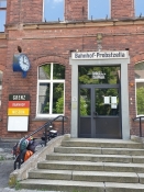
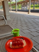
Now I was down in the Loquitz valley, where it was very warm in the sun, but luckily the trees stood closely down here and their foliage was my roof. Now my goal was the legendary East German border station of Probstzella, where the trains from Berlin to Munich used to pass through. Here, the GDR had set up a complicated and invincible border control that made any passage slow and difficult. Unfortunately, the small museum in the railway station had closed. But I made coffee and ate strawberry cake from the bakery in Kleintettau on the platform.
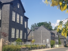
After Probstzella, the terrain rose quite sharply from approx. 330m to 600m within 5km on an okay forest path which just seemed endless. And which required quite a few breather breaks. But at Lichtentanne it turned into an asphalt road and the climb was over. I was a bit pressed for time as I wanted to shop for food in Bad Steben near my destination in Lichtenberg. And there were still more hills in store for me, I knew. In the mining town of Lehesten, where the slate mining industry is visible on every house, I nevertheless took a rest. It was very hot today and many liters of fluid were needed to compensate for all the sweat I secreted.
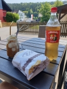
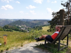
As I trudged up another steep but short hill, a man on the side of the road said, "Last climb before Blankenstein" (where I wouldn't be until tomorrow). It sounded well. But then I realized I had forgotten my sunglasses down on a bench at the bottom of the hill. So I made it twice. Now it was the last one. Well, of course it wasn't, as I turned right towards Lichtenberg and on to Bad Steben: More hills. But I made it to the supermarket and bought a lot.
The campsite was a huge construction mess, but I didn't let that get me down. There was a swimming lake, which I steered purposefully down towards. That bath was well needed. And the food tasted extra good that evening at the closed café's table-bench set. People kept to themselves here, so I maybe I felt a bit lonely, but I didn't want to intrude. And once again I hit the hay before sundown. A certain fatigue also took its toll.
Information about copyright | |
|---|---|
Rights characteristic / license | by-sa: CREATIVE COMMONS Attribution-ShareAlike |
Link to the description of the license | |
taken over / edited on | 04 Aug 2023
|
taken over / edited by |
|
Information about copyright | |
|---|---|
Rights owner | |
Rights characteristic / license | by-sa: CREATIVE COMMONS Attribution-ShareAlike |
Link to the description of the license | |
Image has been uploaded | by on 04 Aug 2023
|
Information about copyright | |
|---|---|
Rights owner | |
Rights characteristic / license | by-sa: CREATIVE COMMONS Attribution-ShareAlike |
Link to the description of the license | |
Image has been uploaded | by on 04 Aug 2023
|
Information about copyright | |
|---|---|
Rights owner | |
Rights characteristic / license | by-sa: CREATIVE COMMONS Attribution-ShareAlike |
Link to the description of the license | |
Image has been uploaded | by on 04 Aug 2023
|
Information about copyright | |
|---|---|
Rights owner | |
Rights characteristic / license | by-sa: CREATIVE COMMONS Attribution-ShareAlike |
Link to the description of the license | |
Image has been uploaded | by on 04 Aug 2023
|
Information about copyright | |
|---|---|
Rights owner | |
Rights characteristic / license | by-sa: CREATIVE COMMONS Attribution-ShareAlike |
Link to the description of the license | |
Image has been uploaded | by on 04 Aug 2023
|
Information about copyright | |
|---|---|
Rights owner | |
Rights characteristic / license | by-sa: CREATIVE COMMONS Attribution-ShareAlike |
Link to the description of the license | |
Image has been uploaded | by on 04 Aug 2023
|