
Cycle Tour Lake Constance - Rhine Valley - Solingen
Travel report: Urlaubstour 2011
Actions
![]()
Please wait - map data are loading
Added on 04 Nov 2011,
last edited by ThimbleU on 16 Dec 2013
Actions
Cycle route metrics
planned
ridden
Total distance in km
928
661
Cumulative elevation gain in m
5.345
3.898
Avg. slope uphill in %
0,58
0,59
Cumulative elevation loss in m
5.587
4.380
Total cycling hours
-
35,7
Avg. pace in km/h
-
18,5
Information about rights to the gps-track data | |
|---|---|
Rights owner | |
Rights characteristic / license | by-nc-sa: CREATIVE COMMONS Attribution-NonCommercial-ShareAlike |
Link to the description of the license | |
GPX file uploaded | by ThimbleU on 04 Nov 2011
|
Track points in total
5.241
8.694
Track points per km (avg)
6
13
Start/endpoint
Start location
Gemeinde Langenargen, Baden-Württemberg, DE (400 m NHN)
End location
Solingen, Nordrhein-Westfalen, DE (158 m NHN)
Stages
Information about copyright | |
|---|---|
Rights owner | |
Rights characteristic / license | © all rights reserved. |
Image has been uploaded | by biroto-Redaktion on 04 Nov 2011
|
107 km
Langenargen - Lottstetten
Information about copyright | |
|---|---|
Rights owner | |
Rights characteristic / license | © all rights reserved. |
Image has been uploaded | by biroto-Redaktion on 04 Nov 2011
|
115 km
Lottstetten - Haltingen
Information about copyright | |
|---|---|
Rights owner | |
Rights characteristic / license | © all rights reserved. |
Image has been uploaded | by biroto-Redaktion on 04 Nov 2011
|
104 km
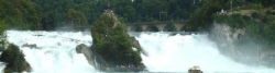
Haltingen - Jechtingen

Information about copyright | |
|---|---|
Rights owner | |
Rights characteristic / license | © all rights reserved. |
Image has been uploaded | by biroto-Redaktion on 04 Nov 2011
|
105 km
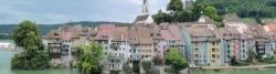
Jechtingen - Scherzheim
Information about copyright | |
|---|---|
Rights owner | |
Rights characteristic / license | © all rights reserved. |
Image has been uploaded | by biroto-Redaktion on 04 Nov 2011
|
123 km
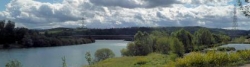
Scherzheim - Speyer

Information about copyright | |
|---|---|
Rights owner | |
Rights characteristic / license | © all rights reserved. |
Image has been uploaded | by biroto-Redaktion on 04 Nov 2011
|
105 km
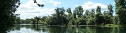
Speyer - Mainz

Information about copyright | |
|---|---|
Rights owner | |
Rights characteristic / license | © all rights reserved. |
Image has been uploaded | by biroto-Redaktion on 04 Nov 2011
|
2 km
Mainz - Solingen
Beds4Cyclists, worth visiting and infrastructure
Name and address
Latitude / Longitude
Phone
Fax
Mobile
Type of accommodation
Rating for cyclists
Route km
Dist. to route
Elevation
0 km
4,5 km
408 m
0 km
4,5 km
401 m
Hours of opening
Sommer (Mai-Sept.)
Mo - Fr 08:00 Uhr bis 18:00 Uhr
Sa, So 10:00 Uhr bis 12:00 Uhr
Winter (Okt.-April)
Mo - Fr 08:00 Uhr bis 12:00 Uhr und 14:00 Uhr bis 17:00 Uhr
0 km
4,3 km
420 m
Topcu-Carlucci & Baumann GbR
DE-88079 Kressbronn-Betznau
Boardinghouse / guest house
0 km
4,6 km
395 m
0 km
0,2 km
395 m
Hours of opening
Mai, Juni, September:
Montag – Freitag 9.00 Uhr – 12.30 Uhr und 13.30 Uhr – 18.00 Uhr
(Juli und August durchgehend 9.00 – 18.00 Uhr)
Samstag, Sonntag, Feiertag 9.00 Uhr – 12.00 Uhr
Juli und August:
Montag – Freitag 9.00 – 18.00 Uhr
Samstag 9.00 – 15.00 Uhr
Sonntag, Feiertag 9.00 Uhr – 13.00 Uhr
Oktober, März und April:
Montag – Donnerstag 9.00 Uhr – 12.00 Uhr und 14.00 Uhr – 16.00 Uhr
Freitag 9.00 Uhr – 12.00 Uhr
![]()