
Cycle Tour Rhine Route EV 15 (left bank)
Planned tour: From Hoek van Holland to Andermatt
Actions
![]()
Please wait - map data are loading
Added on 23 Dec 2023,
last edited by Essteejay on 23 Dec 2023
Actions
Cycle route metrics
planned
ridden
Total distance in km
1.461
0
Cumulative elevation gain in m
11.666
0
Avg. slope uphill in %
0,80
-
Cumulative elevation loss in m
10.232
0
Information about rights to the gps-track data | |
|---|---|
Rights owner | Essteejay & biroto-Contributors |
Rights characteristic / license | cc0: Public Domain no Rights reserved |
Link to the description of the license | |
GPX file taken from | |
GPX file uploaded | by Essteejay on 23 Dec 2023
|
Track points in total
22.374
0
Track points per km (avg)
15
0
Start/endpoint
Start location
Hoek van Holland, ZH, NL (4 m NHN)
End location
Andermatt, UR, CH (1437 m NHN)
Beds4Cyclists, worth visiting and infrastructure
Name and address
Latitude / Longitude
Phone
Fax
Mobile
Type of accommodation
Rating for cyclists
Route km
Dist. to route
Elevation
9 km
5,0 km
-1 m
Information about copyright | |
|---|---|
Rights owner | https://commons.wikimedia.org/w/index.php?title=User:Graaffw |
Rights characteristic / license | by-sa: CREATIVE COMMONS Attribution-ShareAlike |
Link to the description of the license | |
Image taken over from | https://commons.wikimedia.org/wiki/File:060908_020_brielle_centrum.jpg |
Image has been uploaded | by biroto-Redaktion on 31 Dec 2018
|
Information about copyright | |
|---|---|
Rights owner | https://commons.wikimedia.org/w/index.php?title=User:Eldovani |
Rights characteristic / license | by-sa: CREATIVE COMMONS Attribution-ShareAlike |
Link to the description of the license | |
Image taken over from | |
Image has been uploaded | by biroto-Redaktion on 31 Dec 2018
|
Information about copyright | |
|---|---|
Rights owner | |
Rights characteristic / license | by-sa: CREATIVE COMMONS Attribution-ShareAlike |
Link to the description of the license | |
Image taken over from | https://commons.wikimedia.org/wiki/File:BRIELLE_Langepoort.jpg |
Image has been uploaded | by biroto-Redaktion on 31 Dec 2018
|
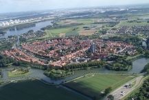
Brielle is a historic and fortified sea side town in the Western Netherlands. It's a town with a long and prominent history, packed with monuments still today. It played a crucial role in the Eighty Years' War, as the Capture of Brielle by the so-called Watergeuzen (or Sea beggars, the Dutch rebels) on the 1st of April 1572 became the beginning of massive Dutch uprising against Spain. Brielle today is a charming town with one of the highest per capita counts of monuments in the country.
Much of the towns fortifications have survived the test of time, and seen from the air, the typical shape of the traditional Old-Dutch fortification structure is still clearly visible.
See
With some 400 buildings and structures on the national heritage list, there's no way to escape some cultural sightseeing in this charming little town.
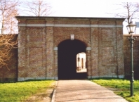
- The main star-shaped structure of defensive walls and canals has changed little since its construction in 1713, making Brielle one of the best preserved fortified towns in the Netherlands. The nine bastions and five ravelins were nicely restored in the 1970s and several of the original city gates are still present. Interesting elements of the walls include a mid-18th-century porter's house as well as:
Other sights include;
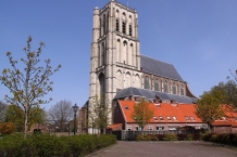
- ⊙Grote of Sint-Catharijnekerk. This massive church would have been the largest in Holland of that time, but the structure was never completed. Building started in 1417 but the last bricks were added in 1482, when only the main nave and a 57 meter tower was completed. A stained glass window depicts the wedding of William of Orange and his third wife, which took place here in 1575, after the church was looted and turned into a Protestant church during the Dutch Reformation. It's possible to climb the stairs of the tower, for a nice view over town.
- ⊙Arsenaal, Corner of Rozemarijnstraat and Lijnbaan. The town's weapon depot was built in 1708 and served as a military structure until 1922. Today, it's the impressive home of Brielle's library.
- ⊙Historic Museum Den Briel in the former City Hall, Markt 1. Tu–Sa 10 AM–5 PM, Su 1–5 PM. This small but comprehensive museum gives an insight in the town's history, particularly of its role in the Eighty Years' War. It is housed in the 18th-century City Hall, for which the façade was created by Johannes van Westenhout in 1790. €4 for adults.
Information about copyright | |
|---|---|
Rights characteristic / license | by-sa: CREATIVE COMMONS Attribution-ShareAlike |
Link to the description of the license | |
Input taken over from: |
Wikivoyage contributors, 'Brielle (Netherlands)', Wikivoyage, The FREE worldwide travel guide that anyone can edit, 18 September 2018, 06:24 UTC, https://en.wikivoyage.org/w/index.php?title=Brielle_(Netherlands)&oldid=3612843 |
taken over / edited on | 31 Dec 2018 - 16 Jul 2022
|
taken over / edited by |
|
27 km
4,6 km
242 m
29 km
0,1 km
-2 m
Hours of opening
Monday 13:00 - 17:00
Tuesday - Friday 9:30 am to 5:00 pm
Saturday 10:00 am - 5:00 pm
Sunday 11:00 - 16:00
34 km
0,6 km
2 m
35 km
0,8 km
5 m
![]()