
Cycle Tour Saint Malo - Cologne
Planned tour
Actions
![]()
Please wait - map data are loading
Added on 12 Mar 2022,
last edited by ThimbleU on 12 Jun 2023
Actions
Cycle route metrics
planned
ridden
Total distance in km
1.384
0
Cumulative elevation gain in m
9.520
0
Avg. slope uphill in %
0,69
-
Cumulative elevation loss in m
9.509
0
Information about rights to the gps-track data | |
|---|---|
Rights owner | ThimbleU & biroto-Contributors |
Rights characteristic / license | cc0: Public Domain no Rights reserved |
Link to the description of the license | |
GPX file taken from | |
GPX file uploaded | by ThimbleU on 12 Jun 2023
|
Track points in total
18.815
0
Track points per km (avg)
14
0
Start/endpoint
Start location
Rennes, BRE, FR (34 m NHN)
End location
Köln, NW, DE (45 m NHN)
Remarks
Diese Tour ist zusammengestellt aus
- dem Radweg Véloscénic (V40) von Saint-Malo bis Versailles,
- dem Radweg Avenue verte Paris - Dieppe (V16) von Croissy-sur-Seine bis Senlis,
- dem EuroVelo-Radweg Pilgerroute (EV3) von Senlis bis Köln.
Beds4Cyclists, worth visiting and infrastructure
Name and address
Latitude / Longitude
Phone
Fax
Mobile
Type of accommodation
Rating for cyclists
Route km
Dist. to route
Elevation
0 km
0,4 km
35 m
0 km
0,1 km
45 m
1 km
0,1 km
54 m
2 km
0,2 km
60 m
2 km
0,1 km
44 m
Information about copyright | |
|---|---|
Rights owner | |
Rights characteristic / license | by-sa: CREATIVE COMMONS Attribution-ShareAlike |
Link to the description of the license | |
Image taken over from | commons.wikimedia.org/wiki/File:Vue_sud-est_de_la_place_du_parlement_de_Bretagne,_Rennes,_France.jpg |
Image has been uploaded | by biroto-Redaktion on 25 Apr 2015
|
Information about copyright | |
|---|---|
Rights owner | |
Rights characteristic / license | by-sa: CREATIVE COMMONS Attribution-ShareAlike |
Link to the description of the license | |
Image taken over from | commons.wikimedia.org/wiki/File:Bretagne_Ille_Rennes2_tango7174.jpg |
Image has been uploaded | by biroto-Redaktion on 25 Apr 2015
|
Information about copyright | |
|---|---|
Rights owner | |
Rights characteristic / license | by-sa: CREATIVE COMMONS Attribution-ShareAlike |
Link to the description of the license | |
Image taken over from | |
Image has been uploaded | by biroto-Redaktion on 25 Apr 2015
|
Information about copyright | |
|---|---|
Rights owner | |
Rights characteristic / license | by-sa: CREATIVE COMMONS Attribution-ShareAlike |
Link to the description of the license | |
Image taken over from | commons.wikimedia.org/wiki/File:Palais_Saint-Georges,_Rennes,_Aug_2010.jpg |
Image has been uploaded | by biroto-Redaktion on 25 Apr 2015
|
Rennes is the capital city of Brittany, France.
Understand
Rennes is not often mentioned on tourist guides but this medium size city is well worth a visit. It has more than 200,000 inhabitants in the municipality itself (more than 300,000 in the urban unit which includes some suburbs in neighbouring municipalities, more than 400,000 in its new "Métropole" created in 2016, and more than 700,000 in the urban area), of whom about 60,000 are students. This gives the city a vibrant nightlife.
Some streets, such as the Rue Saint Michel, have only bars on both sides (The locals actually call Rue Saint Michel "la rue de la soif", which means "street of thirst"). A stroll down Rue Saint Michel on a Friday or Saturday evening is a very interesting experience indeed. However, if you're really in the mood to "faire la fête" (go to party), celebrate or just have fun in other words, the most exciting night on "rue de la soif" would be the "jeudi soir", Thursday nights, during the school year. Jeudi soir is the night when bars are most often packed to the brim with students. The sights on Thursday nights out on the city are very memorable and interesting.
Rennes is particularly nice in early July, during the "Festival des Tombées de la Nuit". Its streets are then full of people enjoying the free street entertainment and eating or drinking at the terraces of the restaurants and cafés.
Rennes used to be virtually empty after the 15th of July, as most of its inhabitants were migrating to the coast until the 15th August. In recent years, this trend seems to have stopped and Rennes's terraces and cafes are now bustling throughout the year, with a very attractive calendar of outdoor and indoor cultural events, a lot of cultural and sportive equipments and a large pedestrian area easily accessible from all municipalities in the metropole by an extensive metro+bus transport network.
See
Rennes is classified as a city of art and history.
Historic centre
The historic centre is located on the former plan of the ramparts. There is a difference between the northern city centre and the southern city centre due to the 1720 fire, which destroyed most of the timber framed houses in the northern part of the city. The rebuilding was done in stone, on a grid plan. The southern part, the poorest at this time, was not rebuilt.
Due to the presence of the parlement de Bretagne, many "hôtels particuliers" were built in the northern part, the richest in the 18th century.
Colourful traditional half-timbered houses are situated primarily along the roads of Saint-Sauveur, Saint-Georges, de Saint-Malo, Saint-Guillaume, des Dames, du Chapitre, Vasselot, Saint-Michel, de la Psallette and around the plazas of Champ-Jacquet, des Lices, Saint-Anne and Rallier-du-Baty.
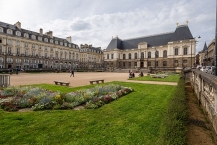
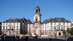
The Parlement de Bretagne and city hall area
The Parlement de Bretagne is the most famous 17th century building in Rennes. It was rebuilt after a terrible fire in 1994 that may have been caused by a flare fired by a protester during a demonstration. It houses the Rennes Court of Appeal. The plaza around is built on the classical architecture.
On the west, the Place de la Mairie (City Hall Plaza, Plasenn Ti Kêr):
- City Hall
- Opera
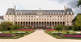
On the east, at the end of the rue saint-Georges with traditional half-timbered houses:
- 1920s Saint George Municipal Pool, with mosaics
- Saint George Palace
 , and its garden
On the south-east:
- Saint-Germain square
- Saint-Germain Church
- Saint-Germain footbridge, 20th century wood and metal construction to link the plaza with Émile Zola Quay, across the Vilaine River.
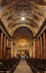
The Place des Lices and Cathedral area
The place des Lices is lined by hôtels particuliers, with the place Railler-du-Baty, is the location of the weekly big market, the marché des Lices.
Near the Rennes Cathedral ![]() (cathédrale Saint-Pierre de Rennes) is the rue du Chapitre:
(cathédrale Saint-Pierre de Rennes) is the rue du Chapitre:
- Hôtel de Blossac
- There are 16th century polychrome wooden busts on the façade of 20, Rue du Chapitre.
On this era are the former St. Yves chapel, now the tourism office and a museum about the historical development of Rennes and the Basilica Saint-Sauveur.
Remains of the ramparts
Built from the 3rd to the 12th centuries, the ramparts were largely destroyed between the beginning of the 16th century and the 1860s.
The Place Saint-Anne area
Place Saint-Anne (Plasenn Santez-Anna)
- Saint-Aubin Church, built in the beginning of the 20th century
- Location of a former 14th century hospital
- Jacobite convent
South-western, la rue Saint-Michel nicknamed Rue de La Soif (Road of Thirst) because there are bars all along this street.
South-eastern, the Champ-Jacquet square, with Renaissance buildings and a statue of mayor Jean Leperdit ripping up a conscription list.
East: the Thabor park area
Area of Saint-Melaine square
Notre-Dame-en-Saint-Melaine basilica,
- tower and transept from the 11th century Benedictine abbey of Saint-Melaine
- 14th century Gothic arcades
- 17th century colonnade
- bell tower topped with a gilded Virgin Mary (19th century)
- 17th century cloister
The Jardin botanique du Thabor ![]() (formal French garden, orangerie, rose garden, aviary) a botanical garden on 10 hectares of land, built between 1860 and 1867.
(formal French garden, orangerie, rose garden, aviary) a botanical garden on 10 hectares of land, built between 1860 and 1867.
The 17th century promenade "la Motte à Madame", and a monumental stairway overlooking the rue de Paris entrance to the Thabor.
South city centre
The south city centre is a mix of old buildings and 19th and 20th centuries constructions.
South of the Vilaine
The Fine Arts Museum is situated on Quai Émile Zola, by the Vilaine ![]() River.
River.
Les Champs Libres is a building on Esplanade Charles de Gaulle, and was designed by the architect Christian de Portzamparc. It houses the Brittany Museum (Musée de Bretagne), the regional library Bibliothèque de Rennes Métropole with six floors, and the Espace des Sciences science centre with a planetarium.
At Place Honoré Commeurec is Les Halles Centrales, a covered market from 1922, with one part converted into contemporary art gallery.
The Mercure Hotel is located in a restored building on rue du Pré-Botté, which was the prior location of Ouest-Éclair, and then of Ouest-France, a premier daily regional newspaper.
There are large mills at Rue Duhamel, constructed on each side of the south branch of the Vilaine in 1895 and 1902.
Information about copyright | |
|---|---|
Rights characteristic / license | by-sa: CREATIVE COMMONS Attribution-ShareAlike |
Link to the description of the license | |
Input taken over from: |
|
taken over / edited on | 25 Apr 2015 - 08 Nov 2022
|
taken over / edited by |
|
![]()