
Cycle Tour Trier - Mulhouse - Mainz
Planned tour
Actions
![]()
Please wait - map data are loading
Added on 30 Apr 2012,
last edited by »TheLonesomeBiker« on 01 May 2012
Actions
Cycle route metrics
planned
ridden
Total distance in km
761
0
Cumulative elevation gain in m
4.912
0
Avg. slope uphill in %
0,65
-
Cumulative elevation loss in m
4.950
0
Information about rights to the gps-track data | |
|---|---|
Rights owner | ThimbleU |
Rights characteristic / license | by-nc-sa: CREATIVE COMMONS Attribution-NonCommercial-ShareAlike |
Link to the description of the license | |
GPX file uploaded | by »TheLonesomeBiker« on 01 May 2012
|
Track points in total
9.058
0
Track points per km (avg)
12
0
Start/endpoint
Start location
Trier, Rheinland-Pfalz, DE (139 m NHN)
End location
Mainz, Rheinland-Pfalz, DE (101 m NHN)
Beds4Cyclists, worth visiting and infrastructure
Name and address
Latitude / Longitude
Phone
Fax
Mobile
Type of accommodation
Rating for cyclists
Route km
Dist. to route
Elevation
0 km
2,0 km
125 m
0 km
4,1 km
127 m
0 km
5,0 km
154 m
0 km
0,4 km
136 m
Information about copyright | |
|---|---|
Rights owner | |
Rights characteristic / license | by-sa: CREATIVE COMMONS Attribution-ShareAlike |
Link to the description of the license | |
Image taken over from | |
Image has been uploaded | by biroto-Redaktion on 23 Feb 2012
|
Information about copyright | |
|---|---|
Rights owner | |
Rights characteristic / license | cc0: Public Domain no Rights reserved |
Link to the description of the license | |
Image taken over from | |
Image has been uploaded | by biroto-Redaktion on 23 Feb 2012
|
Information about copyright | |
|---|---|
Rights owner | |
Rights characteristic / license | by-sa: CREATIVE COMMONS Attribution-ShareAlike |
Link to the description of the license | |
Image taken over from | |
Image has been uploaded | by biroto-Redaktion on 23 Feb 2012
|
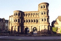
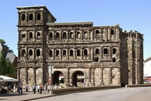
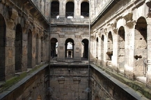
Die Porta Nigra (lateinisch für „Schwarzes Tor“) in Trier ![]() ist ein ehemaliges römisches Stadttor und bekanntes Wahrzeichen der Stadt. Der Name Porta Nigra stammt aus dem Mittelalter. Ein anderer Name im Mittelalter lautete Porta Martis „Tor des Mars“. Von den Trierer Einwohnern wird die Porta Nigra meist nur als „Porta“ bezeichnet.
ist ein ehemaliges römisches Stadttor und bekanntes Wahrzeichen der Stadt. Der Name Porta Nigra stammt aus dem Mittelalter. Ein anderer Name im Mittelalter lautete Porta Martis „Tor des Mars“. Von den Trierer Einwohnern wird die Porta Nigra meist nur als „Porta“ bezeichnet.
Information about copyright | |
|---|---|
Rights characteristic / license | by-sa: CREATIVE COMMONS Attribution-ShareAlike |
Link to the description of the license | |
Input taken over from: |
Seite „Porta Nigra“. In: Wikipedia, Die freie Enzyklopädie. Bearbeitungsstand: 19. Februar 2012, 01:39 UTC. URL: http://de.wikipedia.org/w/index.php?title=Porta_Nigra&oldid=99848444 (Abgerufen: 23. Februar 2012, 17:24 UTC) |
taken over / edited on | 23 Feb 2012 - 31 Jul 2012
|
taken over / edited by |
|
0 km
0,4 km
131 m
![]()