
Cycle Tour Niederrhein-Route
Planned tour
Actions
![]()
Please wait - map data are loading
Added on 16 Aug 2022,
last edited by ThimbleU on 26 Aug 2022
Actions
Cycle route metrics
planned
ridden
Total distance in km
610
0
Cumulative elevation gain in m
3.359
0
Avg. slope uphill in %
0,55
-
Cumulative elevation loss in m
3.181
0
Information about rights to the gps-track data | |
|---|---|
Rights owner | ThimbleU & biroto-Contributors |
Rights characteristic / license | cc0: Public Domain no Rights reserved |
Link to the description of the license | |
GPX file taken from | |
GPX file uploaded | by ThimbleU on 26 Aug 2022
|
Track points in total
8.809
0
Track points per km (avg)
14
0
Start/endpoint
Start location
Xanten, Nordrhein-Westfalen, DE (22 m NHN)
End location
Mittelpilghausen, Nordrhein-Westfalen, DE (200 m NHN)
Remarks
Die Tour folgt im Wesentlichen Teilen der Niederrhein-Route. Das Stück südlich von Viersen und westlich von Mönchengladbach folgt anderen Radwegen.
Beds4Cyclists, worth visiting and infrastructure
Name and address
Latitude / Longitude
Phone
Fax
Mobile
Type of accommodation
Rating for cyclists
Route km
Dist. to route
Elevation
1 km
0,1 km
27 m
Hours of opening
Ganzjährig: Samstag, Sonntag, Feiertage 10.00 bis 17.00 Uhr
April - Oktober: Montag-Freitag 10.00 bis 18.00 Uhr
März - November: Montag-Freitag 10.00 bis 17.00 Uhr
Geschlossen
24, 25. und 31. Dezember, Rosenmontag, Montag nach Fronleichnam und alle zwei Jahre am Karnevalssonntag (Umzug bei gerader Jahreszahl)
1 km
0,5 km
33 m
1 km
4,6 km
9 m
1 km
0,1 km
29 m
2 km
0,0 km
27 m
Information about copyright | |
|---|---|
Rights owner | |
Rights characteristic / license | by-sa: CREATIVE COMMONS Attribution-ShareAlike |
Link to the description of the license | |
Image taken over from | |
Image has been uploaded | by biroto-Redaktion on 10 Jan 2013
|
Information about copyright | |
|---|---|
Rights owner | |
Rights characteristic / license | by-sa: CREATIVE COMMONS Attribution-ShareAlike |
Link to the description of the license | |
Image taken over from | |
Image has been uploaded | by biroto-Redaktion on 10 Jan 2013
|
Information about copyright | |
|---|---|
Rights owner | |
Rights characteristic / license | by-sa: CREATIVE COMMONS Attribution-ShareAlike |
Link to the description of the license | |
Image taken over from | commons.wikimedia.org/wiki/File:Xanten_-_Klever_Tor_05_ies.jpg |
Image has been uploaded | by biroto-Redaktion on 10 Jan 2013
|
Information about copyright | |
|---|---|
Rights owner | |
Rights characteristic / license | by-sa: CREATIVE COMMONS Attribution-ShareAlike |
Link to the description of the license | |
Image taken over from | de.wikipedia.org/w/index.php?title=Datei:Rathaus_Xanten_rIMG_5475_(2).jpg |
Image has been uploaded | by biroto-Redaktion on 10 Jan 2013
|
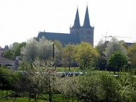
Die Stadt Xanten [ˈksantən] liegt am unteren Niederrhein im Nordwesten Nordrhein-Westfalens.
Hintergrund
Die Römer-, Dom- und Siegfriedstadt Xanten blickt auf eine über 2000-jährige Geschichte zurück. Ihre Anfänge liegen in der Errichtung von Vetera ![]() und der Colonia Ulpia Traiana
und der Colonia Ulpia Traiana ![]() im Römischen Reich und setzen sich fort mit der Gründung des Stifts St. Viktor
im Römischen Reich und setzen sich fort mit der Gründung des Stifts St. Viktor ![]() im 8. Jahrhundert.
im 8. Jahrhundert.
Sehenswürdigkeiten
- Von der römischen Vergangenheit Xantens zeugen der ⊙Archäologische Park Xanten (APX)
 und das Amphitheater in Birten.
 - Von der mittelalterlichen Blütezeit Xantens zeugt vor allem der gotische ⊙St.-Viktor-Dom mit der Stiftsbibliothek und dem Dommuseum, das reiche Kunstschätze ausstellt. Ab 1263 erbaut, gilt St. Viktor als „Größter Dom zwischen Köln und dem Meer“.
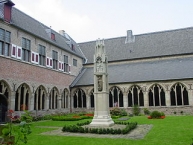
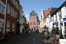
- Der Dom, das ⊙Klever Tor , die ⊙Kriemhildmühle und ihr Gegenstück, die ⊙ Siegfriedmühle, sowie das ⊙Karthaus und weitere historische Gebäude prägen das Bild des mittelalterlichen Stadtkerns.
- Von der einstigen Stadtbefestigung sind neben den bereits genannten ein Mauerturm am Westwall, der ⊙Meerturm, ein Rundturm am Westwall, der ⊙Schweineturm und ein Rundturm am Nordwall erhalten geblieben, die während des 18. Jahrhunderts zumeist umgestaltet wurden. Das 1392 erbaute ⊙Mitteltor zeugt von der einstigen Teilung Xantens in den nördlichen, klevischen und den südlichen, kurkölnischen Teil der Stadt.
- Von der im 10. Jahrhundert im Bereich der Stiftsimmunität errichteten Bischofsburg sind nur noch wenige Mauerreste erhalten. Der als Eckturm der Immunität errichtete Romanische Turm aus dem 11. Jahrhundert ist Teil der Xantener Marienschule.
- Das um 1540 erbaute ⊙Gotische Haus gilt als herausragendes Beispiel der spätgotischen Baukunst am Niederrhein. Es beschreibt anschaulich, durch sein original erhaltenes Holzwerk (Balkendecken und Dachstuhl), die aktive Denkmalpflege in Xanten.
- Das ⊙Arme-Mägde-Haus aus dem späten 16. Jahrhundert wurde errichtet, um den im Viktorstift arbeitenden Frauen ein Heim für ihren Lebensabend zu geben.
- Direkt gegenüber dem Arme-Mägde-Haus steht ein Gotischer Treppengiebel aus dem 15. Jahrhundert.
- Neben der gotischen Architektur sind unter anderem mit Rokokofassaden an Gebäuden aus dem 18. und 19. Jahrhundert, dem barocken Pavillon am östlichen Eckpunkt der Immunität und dem Renaissance-Erker von 1634 weitere Baustile erhalten geblieben.
- Die 1648/49 an der Südecke der Stiftsimmunität erbaute ⊙evangelische Kirche blieb namenlos. Den Kirchturm mit seiner geschweiften Haube erhielt die Kirche erst 1662.
- Die ⊙Michaelskapelle wurde zwischen 1472 und 1478 auf das um 1000 errichtete Südportal der Stiftsimmunität aufgesetzt.
- Die ⊙Fürstenbergkapelle wurde 1671 erbaut und erinnert an das Benediktinerkloster Fürstenberg , das fast 500 Jahre Bestand hatte und 1586 zerstört wurde.
- Das ⊙Rathaus der Stadt wurde ursprünglich als Kapuzinerkloster errichtet.
- Den ⊙Obelisk de Pauw ließ Napoléon 1811 zu Ehren Cornelius de Pauws errichten.
- Zahlreiche Brunnen und Pumpen existieren im Stadtgebiet, wie die ⊙Marktpumpe aus dem Jahr 1736 und der an Norbert von Xanten erinnernde ⊙Norbertbrunnen.
- Die ⊙Alte Kornbrennerei ist das einzige erhaltene Denkmal der Xantener Industriegeschichte des 19. Jahrhunderts. 1853 wurde die Anlage als Ölmühle erbaut und 20 Jahre später zur Dampfkornbrennerei umgerüstet.
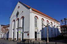
- 2010 wurde im ehemaligen Xantener Regionalmuseum das neue ⊙Museum „Nibelungen(h)ort“ eröffnet, das sich der Geschichte und Rezeption der Nibelungensage widmet.
Information about copyright | |
|---|---|
Rights characteristic / license | by-sa: CREATIVE COMMONS Attribution-ShareAlike |
Link to the description of the license | |
Input taken over from: |
Seite „Xanten“. In: Wikipedia, Die freie Enzyklopädie. Bearbeitungsstand: 15. Dezember 2012, 16:01 UTC. URL: http://de.wikipedia.org/w/index.php?title=Xanten&oldid=111698712 |
taken over / edited on | 10 Jan 2013 - 09 Aug 2022
|
taken over / edited by |
|
![]()