
Cycle Tour Ruhr Valley-Sieg-Rhine-Cycle Loop
Planned tour
Actions
![]()
Please wait - map data are loading
Added on 05 Jul 2013,
last edited by ThimbleU on 16 Dec 2013
Actions
Cycle route metrics
planned
ridden
Total distance in km
469
0
Cumulative elevation gain in m
5.540
0
Avg. slope uphill in %
1,18
-
Cumulative elevation loss in m
5.528
0
Information about rights to the gps-track data | |
|---|---|
Rights owner | ThimbleU & biroto-Contributors |
Rights characteristic / license | by-sa: CREATIVE COMMONS Attribution-ShareAlike |
Link to the description of the license | |
GPX file taken from | |
GPX file uploaded | by ThimbleU on 05 Jul 2013
|
Track points in total
7.463
0
Track points per km (avg)
16
0
Start/endpoint
Start location
Haan, Nordrhein-Westfalen, DE (174 m NHN)
End location
Haan, Nordrhein-Westfalen, DE (187 m NHN)
Signposting
Radweg Kaierroute von Baumberg bis Kupferdreh |
|
RuhrtalRadweg von Kupferdreh bis Wennemen |
|
Sieg-Radweg von Kirchen (Sieg) bis Siegburg |
|
Rhein-Radweg von Siegburg bis Baumberg |
|


Beds4Cyclists, worth visiting and infrastructure
Name and address
Latitude / Longitude
Phone
Fax
Mobile
Type of accommodation
Rating for cyclists
Route km
Dist. to route
Elevation
1 km
0,1 km
135 m
Information about copyright | |
|---|---|
Rights owner | |
Rights characteristic / license | by-sa: CREATIVE COMMONS Attribution-ShareAlike |
Link to the description of the license | |
Image taken over from | |
Image has been uploaded | by biroto-Redaktion on 17 Apr 2012
|
Information about copyright | |
|---|---|
Rights owner | |
Rights characteristic / license | by-sa: CREATIVE COMMONS Attribution-ShareAlike |
Link to the description of the license | |
Image taken over from | commons.wikimedia.org/wiki/File:Mühle-und-Gut-zu-Schöller.jpg |
Image has been uploaded | by biroto-Redaktion on 17 Apr 2012
|
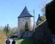
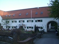
Das Rittergut Schöller (auch mit der Bezeichnung: Herrschaft Schöller und Herrlichkeit Schöller) ist ein abgegangener Adelssitz der Herren von Schöller im Wuppertaler ![]() Ortsteil Schöller
Ortsteil Schöller ![]() .
.
Der Bergfried und ein Teil der Burgmauer sind der letzte erhaltene Rest des ehemaligen Herrensitzes Schoeler, der aus dem späten 12. Jahrhundert stammt. Der Bergfried gehört heute zum Gut Schöller, besitzt die Hausanschrift Zur Düssel 2 und wird im Volksmund Schinderhannesturm genannt.
Information about copyright | |
|---|---|
Rights characteristic / license | by-sa: CREATIVE COMMONS Attribution-ShareAlike |
Link to the description of the license | |
Input taken over from: |
Seite „Rittergut Schöller“. In: Wikipedia, Die freie Enzyklopädie. Bearbeitungsstand: 17. Oktober 2011, 16:33 UTC. URL: http://de.wikipedia.org/w/index.php?title=Rittergut_Sch%C3%B6ller&oldid=94895514 (Abgerufen: 17. April 2012, 11:29 UTC) |
taken over / edited on | 17 Apr 2012
|
taken over / edited by |
|
2 km
2,6 km
Direkt am Radweg Korkenziehertrasse - Nordbahntrasse - Kohlenbahn mit einer Vielzahl von getakteten Regionalverkehrs-Relationen:
S9 Wuppertal - Essen - Bottrop - (Halterm)
S5/S8 Mönchengladbach - Wuppertal - Hagen - Dortmund
RE4 Aachen Mönchengladbach - Wuppertal - Hagen - Dortmund
R13 Venlo - Viersen - Düsseldorf - Wuppertal - Hagen - Hamm
RB48 Bon - Köln - Leverkusen - Solingen - Wuppertal
Information about copyright | |
|---|---|
Rights characteristic / license | by-sa: CREATIVE COMMONS Attribution-ShareAlike |
Link to the description of the license | |
taken over / edited on | 06 Dec 2015
|
taken over / edited by |
|
5 km
0,0 km
134 m
Information about copyright | |
|---|---|
Rights owner | |
Rights characteristic / license | by-sa: CREATIVE COMMONS Attribution-ShareAlike |
Link to the description of the license | |
Image taken over from | |
Image has been uploaded | by biroto-Redaktion on 17 Apr 2012
|
Information about copyright | |
|---|---|
Rights owner | |
Rights characteristic / license | by-sa: CREATIVE COMMONS Attribution-ShareAlike |
Link to the description of the license | |
Image taken over from | commons.wikimedia.org/wiki/File:Dorf_Düssel_-_Kirche_St._Maximin.jpg |
Image has been uploaded | by biroto-Redaktion on 17 Apr 2012
|
Information about copyright | |
|---|---|
Rights owner | |
Rights characteristic / license | by-sa: CREATIVE COMMONS Attribution-ShareAlike |
Link to the description of the license | |
Image taken over from | commons.wikimedia.org/wiki/File:Duessel_evangelische_kirche.jpg |
Image has been uploaded | by biroto-Redaktion on 17 Apr 2012
|
Information about copyright | |
|---|---|
Rights owner | |
Rights characteristic / license | by: CREATIVE COMMONS Attribution |
Link to the description of the license | |
Image taken over from | |
Image has been uploaded | by biroto-Redaktion on 17 Apr 2012
|
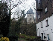
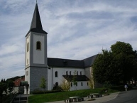
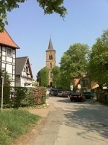
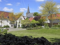
Düssel hat einen weitgehend erhaltenen historischen Ortskern. Sehenswert ist und insbesondere die Wasserburg Düssel ![]() mit zum größten Teil erhaltenen Burggraben sowie die aus dem 11. Jahrhundert stammende kath. Kirche St. Maximin
mit zum größten Teil erhaltenen Burggraben sowie die aus dem 11. Jahrhundert stammende kath. Kirche St. Maximin ![]() . Dominierende Gebäude des Ortskerns sind darüber hinaus die evangelische Kirche
. Dominierende Gebäude des Ortskerns sind darüber hinaus die evangelische Kirche ![]() und ein Sparkassengebäude am ehemaligen Marktplatz. Davor befindet sich eine lebensgroße Bronzeplastik des aus Düssel stammenden bergischen Heimatdichters Carl Schmachtenberg.
und ein Sparkassengebäude am ehemaligen Marktplatz. Davor befindet sich eine lebensgroße Bronzeplastik des aus Düssel stammenden bergischen Heimatdichters Carl Schmachtenberg.
Information about copyright | |
|---|---|
Rights characteristic / license | by-sa: CREATIVE COMMONS Attribution-ShareAlike |
Link to the description of the license | |
Input taken over from: |
Seite „Düssel (Wülfrath)“. In: Wikipedia, Die freie Enzyklopädie. Bearbeitungsstand: 13. September 2011, 20:25 UTC. URL: http://de.wikipedia.org/w/index.php?title=D%C3%BCssel_(W%C3%BClfrath)&oldid=93619230 (Abgerufen: 17. April 2012, 11:34 UTC) |
taken over / edited on | 17 Apr 2012 - 25 Nov 2013
|
taken over / edited by |
|
5 km
2,6 km
169 m
Information about copyright | |
|---|---|
Rights owner | |
Rights characteristic / license | by-sa: CREATIVE COMMONS Attribution-ShareAlike |
Link to the description of the license | |
Image taken over from | https://commons.wikimedia.org/wiki/File:Wülfrath_kirchplatz.jpg |
Image has been uploaded | by biroto-Redaktion on 21 Nov 2013
|
Information about copyright | |
|---|---|
Rights owner | |
Rights characteristic / license | by-sa: CREATIVE COMMONS Attribution-ShareAlike |
Link to the description of the license | |
Image taken over from | |
Image has been uploaded | by biroto-Redaktion on 21 Nov 2013
|
Information about copyright | |
|---|---|
Rights owner | https://commons.wikimedia.org/w/index.php?title=User:Hpschaefer |
Rights characteristic / license | by-sa: CREATIVE COMMONS Attribution-ShareAlike |
Link to the description of the license | |
Image taken over from | https://commons.wikimedia.org/wiki/File:Wuelfrath_ansicht_zentrum.jpg |
Image has been uploaded | by biroto-Redaktion on 21 Nov 2013
|
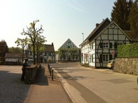
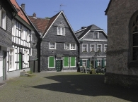
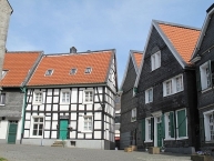
Wülfrath ist eine mittlere kreisangehörige Stadt im Kreis Mettman.
Wülfrath besitzt einen sehenswerten historischen Kirchplatz und eine ebenso schöne kleine Altstadt mit Fussgängerzone.
Information about copyright | |
|---|---|
Rights characteristic / license | by-sa: CREATIVE COMMONS Attribution-ShareAlike |
Link to the description of the license | |
Input taken over from: |
Seite „Wülfrath“. In: Wikipedia, Die freie Enzyklopädie. Bearbeitungsstand: 17. November 2013, 15:57 UTC. URL: http://de.wikipedia.org/w/index.php?title=W%C3%BClfrath&oldid=124552090 (Abgerufen: 21. November 2013, 16:22 UTC) |
taken over / edited on | 21 Nov 2013
|
taken over / edited by |
|
5 km
1,5 km
214 m
![]()