
FAQ and instructions
- FAQ
- I did not receive the verification mail. What to do?
- How do I make my individual cycling tour?
- How can gpx data be downloaded?
- Why does the downloaded GPX track contain only a part of the track?
- How can the direction of a track be reversed?
- Routes
- How do I navigate to the page of a route or tour?
- Tours
- How do I create a page with my individual tour?
- How do I do the stage planning for my tour?
- How do I create stage target locations for my tour?
- How do I change stage target locations for my tour?
- How can accommodation be booked for my tour?
- How do I navigate to the page of a route or tour?
- Travel reports
- How do I navigate to the page of a stage?
- How do I print a travel report?
- Cycling Guide as your travel guide
- How do I print a Cycling Guide?
- How can a Cycling Guide be created as a pdf?
- Infrastructure along cycle routes
- Accommodation
- What accommodations should be included?
- Who may add accommodations?
- How can additional accommodations are included?
- How do I navigate to the page of an accommodation establishment?
- How can accommodation be booked for my tour?
- Sights
- How can additional sights are included?
- Other infrastructure
- How can additional infrastructure-objects are included?
- Accommodation
- User (MyBicycleRoutesPortal)
- Favourites
- What are the favourites for?
- How do I navigate to the page of a my favourite routes/tours?
- How to add a route/tour to the favourites?
- How to set/change the category/period of a route/tour in the favourites?
- How to remove a route/tour from the favourites?
- Own routes and tours
- Own infrastructure objects
- Own Messages
- Cyclist profile
- What is the cyclist profile for?
- How to add/remove an information on personal matters to the cyclist profile?
- How to add a tour to the cyclist profile?
- How to remove a tour from the cyclist profile?
- Favourites
- Maps
- How do I adjust map content?
- gpx-data
- What are gpx data?
- What gpx data may be uploaded (legally)?
- What gpx data can be uploaded (technically)?
- How can gpx data be uploaded?
- How can gpx data be changed?
- How can gpx data be deleted?
- How can gpx data be downloaded?
- How can the direction of a track be reversed?
- Why does the downloaded GPX track contain only a part of the track?
- Which trackpoint limits apply to which GPS device?
- Images
- What images may be uploaded (legally)?
- What images can be uploaded (technically)?
- How can images be uploaded?
- How can images be changed?
- How can images be deleted?
- Text editor
- How do I make text with the text editor?
- External Tools
- GPSies.com
- BRouter
- RouteConverter
- How can RouteConverter be obtained and installed?
- Structure of the editing window of the RouteConverter
- How can gpx-tracks be tailored?
- How can gpx-tracks be composed?
- How can elevation information be supplemented to gpx-tracks?
- How can track-data be converted into gpx-format?
How do I adjust map content?
The maps used on the the Website can be customized by the user with regard to zoom level, window size, type of map and map overlays.
For this purposes buttons are available on the maps:
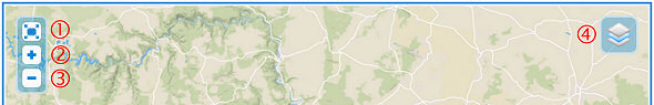
(1) Enlarge the map to full window size / resize the map window to original size
(2) Zoom into the map
(3) Zoom out of the map
(4) Selection of the type of map and the map overlays
In the selection pop-up (4) different options can be displayed.
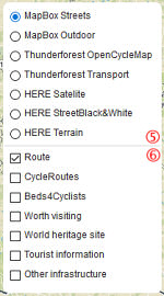 In principle, it is constructed as follows:
- In the upper part of the selection pop-up (5) the available maps are displayed. The selected map forms the background of the image in the map window.
- Below the line (6) the possible overlays are available for selection. The overlays are displayed "in front" of the map. The overlays overlap and hide information of the map. There can be none, one, or several overlays selected at the same time.
The following are examples of the available maps:
Map | Zoom level 9 | Zoom level 16 |
|---|---|---|
SIGMA | 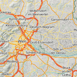 |  |
SIGMA | 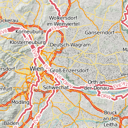 | 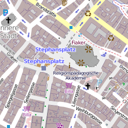 |
Thunderforest Transport |  | 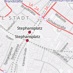 |
HERE |  | 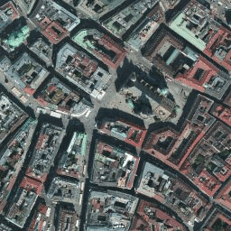 |
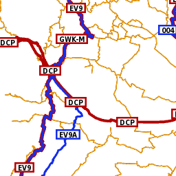
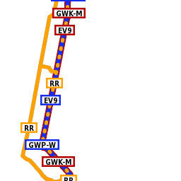
In the overlays area the following options can be displayed (depending on the the context of the map):
- Route
Illustration of the course of cycle routes. Only available in case of official cycle routes. - Tour (as planned)
Illustration of the course of planned cycle tours. Only available in case of individual tours. - Stages (as ridden)
Illustration of the course of ridden stages of a tour. Only available on tour pages. - This Stage (as ridden)
Illustration of the course of a ridden stage of a tour. Only available on stage pages. - Interesting tours
Illustration of the course of interesting tours. Only available page »MyFavourites«. - Planned tours
Illustration of the course of planned tours.
Only available on pages »MyFavourites« and »Cyclist's profile«. - Ridden tours
Illustration of the course of ridden tours.
Only available on pages »MyFavourites« and »Cyclist's profile«. - Tours
Illustration of the course of individual tours.
Only available on page »MyRoutes&Tours« and page »Find cycle routes and tours«. - Routes >= 2000 km
Illustration of the course of cycle routes having more than 2000 km of length.
Only available on page »MyRoutes&Tours« and page »Find cycle routes and tours«. - Routes >= 600 - < 2000 km
Illustration of the course of cycle routes having more than 600 and less than 2000 km of length.
Only available on page »MyRoutes&Tours« and page »Find cycle routes and tours«. - Routes >= 120 - < 600 km
Illustration of the course of cycle routes having more than 120 and less than 600 km of length.
Only available on page »MyRoutes&Tours« and page »Find cycle routes and tours«. - Routes < 120 km
Illustration of the course of cycle routes having less than 120 km of length.
Only available on page »MyRoutes&Tours« and page »Find cycle routes and tours«. - CycleRoutes
Cycle Routes recorded on OpenstreetMapZoom level 9
Zoom level 16
CycleRoutes
Beds4Cyclists
Display the cyclistfriendly accommodations recorded on birotoIcon
Meaning
Icon
Meaning
Hotel / boardinghouse/ guesthouse / B&B / holiday flat / apartment / hostel
Hotel / boardinghouse/ guesthouse / B&B / holiday flat / apartment / hostel
with certificationYouth Hostel
Camping ground
Worth visiting
Display the sights and attractions recorded on birotoIcon
Meaning
Icon
Meaning
Church / cathedral
Castle / palace
Manor
Old town
Industrial heritage
Abbey / convent
Museum
Archaeological site
Natural monument
Bridge
Well worth seeing landscape
Heritage building(s)
Memorial
Remarkable Art
Sports facility
World Heritage Sites
Display the World Heritage Sites recorded on birotoIcon
Meaning
Icon
Meaning
World Heritage Site
Tourist information
Display the Tourist Information Centres recorded on birotoIcon
Meaning
Icon
Meaning
Tourist Information Centre
Other infrastructure
Display the other infrastructure recorded on birotoIcon
Meaning
Icon
Meaning
Bicycle Repair Shop
Cash Machine (ATM)
Ferry / Ferry pier
Station
Bus stop
e-bike charging station
Bikebox
No bicycles
Border checkpoint