
Cycle Tour Canal des 2 mers - Mediterranean route - Cycle route Switzerland-Mediterranean
13. Etappe: Flayosc - Peymeinade
![]()
Please wait - map data are loading
Added on 13 Jun 2018
last edited by ThimbleU on 25 Sep 2018
Cycle route metrics
ridden
Total distance in km
74
Cumulative elevation gain in m
887
Avg. slope uphill in %
1,20
Cumulative elevation loss in m
997
Total cycling hours
5,1
Avg. pace in km/h
14,5
Min. height
111
Max. height
460
Information about rights to the gps-track data | |
|---|---|
Rights owner | |
Rights characteristic / license | cc0: Public Domain no Rights reserved |
Link to the description of the license | |
GPX file uploaded | by ThimbleU on 30 Jun 2018
|
Track points in total
1.576
Track points per km (avg)
21
Start/endpoint
Start location
Flayosc, Provence-Alpes-Côte d'Azur, FR (303 m NHN)
End location
Peymeinade, Provence-Alpes-Côte d'Azur, FR (193 m NHN)
ridden on
30 Jun 2018
Weather
Sunny.
Accommodation
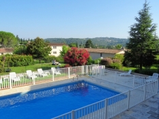
Hôtel de la Poste à Peymeinade
86 Avenue de Boutigny
FR-06530 Peymeinade
Signposting
From Flayosc to Fayence and at Callian signposting with the logo of the temporary or final EV8. |
|


Properties
asphalt | 73,3 km | 98,6 % |
asphalt very bad to cycle | 0,6 km | 0,9 % |
very steep with partly very bad surface. | 0,4 km | 0,5 % |
The information relates to the track as traveled!
Slope Gradient Distribution
Travel report
Breakfast at the Chambres d'hôtes was outstanding. Rarely have we had such a varied and good range of food.
From the property we cycled out of Flayosc on side roads to road D57. On this we warmed up on first 110 meters up the hill. Evenly rising and shaded by oak trees, at only 24° C. It is the temporary route of the EV8, chosen to avoid the busier D557.
After 1½ kilometers at almost the same height begins the descent to Draguignan. It went down 180 meters of elevation. The descent is less even and the surface is worse than at the ascent.
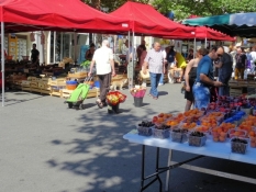
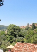
In the old town of Draguignan was weekly market. We provided us with baked goods and fruit for the day.
Then we cycled back to the bike path and followed the EV8 signs out of town. We came for a short section on road D59 and then turned onto the Avenue de la Vaugine. With 2½ % incline we pedaled uphill the old railway line. Then the signage to turn left. In front of us it went uphill very steeply. At a length of 500 meters we climbed up 65 meters, the road surface was partly ok, sometimes miserable. In any case, it was difficult to push up the bikes including our luggage.
Note: If you want to avoid this section, you should take road D562 in Draguignan and cycle on this up the entire ascent. Or change from road D562 to the Vieille Route de Grasse and take this until Saint-Esprit. |
Information about copyright | |
|---|---|
Rights characteristic / license | by-sa: CREATIVE COMMONS Attribution-ShareAlike |
Link to the description of the license | |
taken over / edited on | 24 Sep 2018 - 25 Sep 2018
|
taken over / edited by |
|
Information about copyright | |
|---|---|
Rights owner | |
Rights characteristic / license | © all rights reserved. |
Image has been uploaded | by ThimbleU on 25 Sep 2018
|
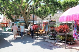
After the section to push we cycled down the hill on road D562 and then turned left onto the rail trail. After a kilometer came again a short section on road D54, then it turned right onto rural roads. At this point, the Vieille Route de Grasse also meets road D54. On the rural roads we cycled through the fields with almost no traffic, met a group of older Frenchmen who stood together for a chat. We came back to road D54. But immediately we changed again onto the rail trail. For 3½ kilometers we cycled uphill through forests and through vineyards. Before Callas we had to leave the road and cycled on another road through the town, then again a steeper section up to the Place George Clemenceau in Callas. There was currently the weekly market.
On side roads we were led out of Callas following the signage. One-way regulations lead here to different roads for the directions. We came up behind the Catholic church to the street La Colle, which due to the steepness (34 meters in altitude to 300 meters in length) again necessitates us to push.
Note: If you want to avoid the section to push, you can cycle uphill road D25 from Callas and will arrive at the same place. |
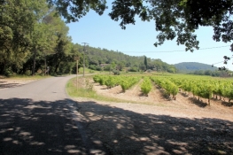
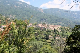
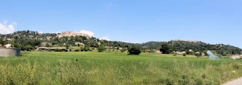
Then we cycled on road D25 almost five kilometers high above the valley with magnificent views of Claviers, Bargemon and the far valley. The small differences in elevation on this section are easy to handle.
Information about copyright | |
|---|---|
Rights characteristic / license | by-sa: CREATIVE COMMONS Attribution-ShareAlike |
Link to the description of the license | |
taken over / edited on | 25 Sep 2018
|
taken over / edited by |
|
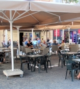
Shortly before Bargemon, a bench invited us to take a break. In the shade of the plane trees we spent a quarter of an hour. In the main square of the village cafés and restaurants were already well visited. Behind that began a descent of 100 meters altitude.
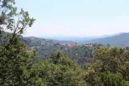
To the left we came back onto the rail trail. For three kilometers of length, it climbs up, mostly slightly, to Claviers, passes the village and then runs for another two kilometers below road D55. Then on the left a short section up the slope and onwards on the local road. It went through sparse pine forest uphill and on the other side downhill in serpentines.
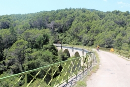
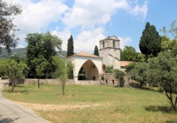
On the left side we met again on the rail trail. This time we stayed on the bike path for eleven kilometers. Below Seillans we cycled across the Viaduc du Rayol which has a length of 159 meters. At the former station Seillans we arrived at the Romanesque chapel Notre Dame de L'Ormeau.
Information about copyright | |
|---|---|
Rights characteristic / license | by-sa: CREATIVE COMMONS Attribution-ShareAlike |
Link to the description of the license | |
taken over / edited on | 25 Sep 2018
|
taken over / edited by |
|
At Fayence, the signposted temporary bike path EV8 ended.
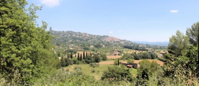
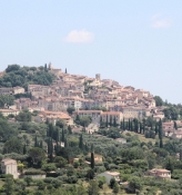
We continued on road D19. The road is narrow and has a higher traffic volume. After four kilometers, at the roundabout, we turned left towards Callian. The traffic is immediately less. Above us on the hillside Callian and to the right Montuaroux. We stayed at the bottom of the valley and continued downhill on narrow roads.
Information about copyright | |
|---|---|
Rights characteristic / license | by-sa: CREATIVE COMMONS Attribution-ShareAlike |
Link to the description of the license | |
taken over / edited on | 25 Sep 2018
|
taken over / edited by |
|
In a big roundabout we finally came across road D562. From here we had to cycle on the road 50 meters of elevation uphill. A bike lane is available only occasionally and narrow. Then we quickly rolled downhill for five kilometers (around 140 meters of elevation). Unfortunately we had to go back to Peymeinade on the other side of the valley. There were 130 meters of elevation on almost three kilometers. On the right side in the valley we could see remnants of the Viaduc de Siagne, the once 229 meter long bridge over the valley of the Siagne. This bridge will probably not be rebuilt for the final course of the bike path.
For us it was still two kilometers until the hotel. We were glad to get out of the bike clothes at this 31° C warm day.
Information about copyright | |
|---|---|
Rights characteristic / license | by-sa: CREATIVE COMMONS Attribution-ShareAlike |
Link to the description of the license | |
taken over / edited on | 25 Sep 2018
|
taken over / edited by |
|
Information about copyright | |
|---|---|
Rights owner | |
Rights characteristic / license | © all rights reserved. |
Image has been uploaded | by ThimbleU on 25 Sep 2018
|
Information about copyright | |
|---|---|
Rights owner | |
Rights characteristic / license | © all rights reserved. |
Image has been uploaded | by ThimbleU on 25 Sep 2018
|