
Rhine Cycle Route
No. of cycle route D8
Actions
![]()
Please wait - map data are loading
Added on 19 Mar 2012,
last edited by biroto-Redaktion on 12 Nov 2023
Actions
Cycle route metrics
Total distance in km
1.086
Information about rights to the gps-track data | |
|---|---|
Rights owner | OpenStreetMap and Contributors + biroto-Redaktion (biroto.eu) |
Rights characteristic / license | Contains information from OpenStreetMap, which is made available here under the Open Database License(ODbL) |
Link to the description of the license | |
GPX file taken from | |
GPX file uploaded | by biroto-Redaktion on 12 Nov 2023
|
Track points in total
16.090
Track points per km (avg)
15
Start/endpoint
Start location
Lindau (Bodensee), BY, DE (400 m NHN)
End location
Kleve, NW, DE (13 m NHN)
Signposting
Die Rhein-Route als eine der D-Routen ist durchgängig mit dem Logo der D8 ausgeschildert. |
|
In NRW nennt er sich auch Erlebnisweg Rheinschiene und ist dort zusätzlich mit dessen Logo ausgeschildert. |
|


Sources of information
Bücher:
- Esterbauer bikeline: Rhein-Radweg
Teil 1: Von Andermatt nach Basel, Radtourenbuch, wetterfest/reißfest - Esterbauer bikeline: Rhein-Radweg
Teil 2: Von Basel nach Mainz. Radtourenbuch, 1:75.000, 807 km, wetterfest/reißfest - Esterbauer bikeline: Rhein-Radweg
Teil 3. Von Mainz nach Duisburg. Radtourenbuch, 1:75.000, 302 km, mit Erlebnisweg Rheinschiene, wetterfest/reißfest - Esterbauer bikeline: Rhein-Radweg
Teil 4: Niederrhein · Von Köln nach Hoek van Holland. Radtourenbuch, 1:75.000, 442 km, wetterfest/reißfest
Connecting cycle path
- bei Konstanz
- bei Basel
- bei Kleve
Travel reports about cycle tours
Information about copyright | |
|---|---|
Rights owner | |
Rights characteristic / license | © all rights reserved. |
Image has been uploaded | by biroto-Redaktion on 04 Nov 2011
|
06 Aug 2011
107 km
A stage of the tour »Lake Constance - Rhine Valley - Solingen« of user ThimbleU
Information about copyright | |
|---|---|
Rights owner | |
Rights characteristic / license | © all rights reserved. |
Image has been uploaded | by biroto-Redaktion on 04 Nov 2011
|
08 Aug 2011
104 km
A stage of the tour »Lake Constance - Rhine Valley - Solingen« of user ThimbleU
Information about copyright | |
|---|---|
Rights owner | |
Rights characteristic / license | © all rights reserved. |
Image has been uploaded | by biroto-Redaktion on 04 Nov 2011
|
09 Aug 2011
105 km
A stage of the tour »Lake Constance - Rhine Valley - Solingen« of user ThimbleU
Information about copyright | |
|---|---|
Rights owner | |
Rights characteristic / license | © all rights reserved. |
Image has been uploaded | by biroto-Redaktion on 04 Nov 2011
|
10 Aug 2011
123 km
A stage of the tour »Lake Constance - Rhine Valley - Solingen« of user ThimbleU
21 Aug 2013
117 km
A stage of the tour »River Main Cycle Route and Middle Rhine Valley« of user ThimbleU
22 Aug 2013
123 km
A stage of the tour »River Main Cycle Route and Middle Rhine Valley« of user ThimbleU
Beds4Cyclists, worth visiting and infrastructure
Name and address
Latitude / Longitude
Phone
Fax
Mobile
Type of accommodation
Rating for cyclists
Route km
Dist. to route
Elevation
0 km
3,8 km
396 m
0 km
0,0 km
385 m
Hours of opening
Montag, Dienstag und Donnerstag – Samstag | 09:00 Uhr – 12:30 Uhr |
Mittwoch | 09:00 Uhr – 12:30 Uhr |
0 km
4,9 km
396 m
0 km
0,3 km
409 m
Information about copyright | |
|---|---|
Rights owner | |
Rights characteristic / license | cc0: Public Domain no Rights reserved |
Link to the description of the license | |
Image taken over from | |
Image has been uploaded | by biroto-Redaktion on 02 Jan 2012
|
Information about copyright | |
|---|---|
Rights owner | |
Rights characteristic / license | by-sa: CREATIVE COMMONS Attribution-ShareAlike |
Link to the description of the license | |
Image taken over from | |
Image has been uploaded | by biroto-Redaktion on 02 Jan 2012
|
Information about copyright | |
|---|---|
Rights owner | |
Rights characteristic / license | by-sa: CREATIVE COMMONS Attribution-ShareAlike |
Link to the description of the license | |
Image taken over from | |
Image has been uploaded | by biroto-Redaktion on 02 Jan 2012
|
Information about copyright | |
|---|---|
Rights owner | |
Rights characteristic / license | by: CREATIVE COMMONS Attribution |
Link to the description of the license | |
Image taken over from | commons.wikimedia.org/wiki/File:Lindau_Stiftskirche_und_St_Stephan.jpg |
Image has been uploaded | by biroto-Redaktion on 02 Jan 2012
|
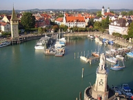
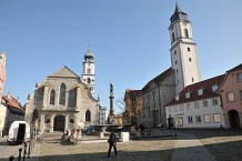
Lindau is a city in southern Bavaria on the shore of Lake Constance or the Bodensee. It lies on the border to the Austrian federal-state of Vorarlberg with its capital city Bregenz which is within walking distance (about 10km along the lake). The historic town is on an island and full of medieval and half-timbered buildings. One can also take boat tours leaving the small harbor and just sit and enjoy a Weissbier admiring the view of Austria and Switzerland and the Alps across the lake.
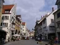
On a sunny day in summer Lindau is a great place to be. The town is old and very beautiful and has a good market.
See
First step after reaching Lindau should be to contact the tourist info centre just outside the train station, where one can get a list of beautiful buildings in the town and a free map too. On a sunny day, the views that this town offers are awesome.
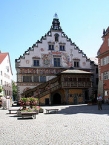
- ⊙Old City Hall (Altes Rathaus), Bismarckplatz 4. Construction started in 1422 and took about 14 years to complete. Make sure to also look at the south facade.
- ⊙Lighthouse. Climb the lighthouse (33m). Views are great from that height. €1.80 adults, €0.70 children.
- ⊙Mangturm, Seepromenade. A tower (20m) that was built in the 12th century as part of the town's defence wall. The interior is only accessible as part of a "fairy tale" event - for adults May-Sep every Friday at 19:00 and for children during the summer holidays (beginning of Aug- beginning of September) every Tuesday 10:30. Adults €8, children €3.
- ⊙Diebsturm, Zeppelinstraße (On the island). Constructed in 1380 as part of the city walls. It was also used as a prison, hence the name.
- ⊙Stadtmuseum (City Museum), Marktplatz 6 (on the market place), ☎ +49 8382 944073. Only open during the summer season. Museum with collections about the history of the city. A collection of mechanical musical instruments can be seen on a guided tour. There are also changing art exhibitions. The building of the museum, called Cavazzen, is an impressive baroque building from 1729. €3 adults, €1.50 consessions.
- ⊙Bavarian Lion.
Information about copyright | |
|---|---|
Rights characteristic / license | by-sa: CREATIVE COMMONS Attribution-ShareAlike |
Link to the description of the license | |
Input taken over from: |
Wikivoyage contributors, 'Lindau', Wikivoyage, The FREE worldwide travel guide that anyone can edit, 7 May 2016, 04:56 UTC, <https://en.wikivoyage.org/w/index.php?title=Lindau&oldid=2988123> [accessed 19 September 2016] |
taken over / edited on | 19 Sep 2016
|
taken over / edited by |
|
0 km
0,3 km
416 m
![]()