
Cycle Tour Vom Bodensee über Genfersee nach Basel
Tag 15: Fleurier nach Les Breuleux
![]()
Please wait - map data are loading
Added on 06 Apr 2017
last edited by Tandemteam-Traudel_und_Dieter on 14 Apr 2017
Cycle route metrics
ridden
Total distance in km
74
Cumulative elevation gain in m
1.679
Avg. slope uphill in %
2,27
Cumulative elevation loss in m
1.408
Total cycling hours
5,1
Avg. pace in km/h
14,5
Min. height
722
Max. height
1.249
Information about rights to the gps-track data | |
|---|---|
Rights owner | |
Rights characteristic / license | by-sa: CREATIVE COMMONS Attribution-ShareAlike |
Link to the description of the license | |
GPX file uploaded | by Tandemteam-Traudel_und_Dieter on 08 Apr 2017
|
Track points in total
1.133
Track points per km (avg)
15
Start/endpoint
Start location
Val-de-Travers, Neuenburg, CH (743 m NHN)
End location
Bergtramlingen, Bern, CH (1014 m NHN)
ridden on
10 Aug 2012
Weather
Sonne
Properties
Teer
Travel report
Information about copyright | |
|---|---|
Rights owner | |
Rights characteristic / license | © all rights reserved. |
Image has been uploaded | by Tandemteam-Traudel_und_Dieter on 08 Apr 2017
|
Information about copyright | |
|---|---|
Rights owner | |
Rights characteristic / license | © all rights reserved. |
Image has been uploaded | by Tandemteam-Traudel_und_Dieter on 08 Apr 2017
|
Information about copyright | |
|---|---|
Rights owner | |
Rights characteristic / license | © all rights reserved. |
Image has been uploaded | by Tandemteam-Traudel_und_Dieter on 08 Apr 2017
|
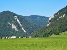
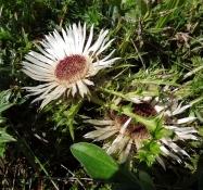
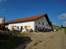
Heute Morgen wollten wir erst zur Quelle der Areuse bei Saint-Sulpice radeln. In Saint-Sulpice sind wir umgekehrt, weil uns die Zeit zu knapp geworden wäre.
Information about copyright | |
|---|---|
Rights characteristic / license | by-sa: CREATIVE COMMONS Attribution-ShareAlike |
Link to the description of the license | |
taken over / edited on | 08 Apr 2017
|
taken over / edited by |
|
Information about copyright | |
|---|---|
Rights owner | |
Rights characteristic / license | © all rights reserved. |
Image has been uploaded | by Tandemteam-Traudel_und_Dieter on 08 Apr 2017
|
Information about copyright | |
|---|---|
Rights owner | |
Rights characteristic / license | © all rights reserved. |
Image has been uploaded | by Tandemteam-Traudel_und_Dieter on 08 Apr 2017
|
Information about copyright | |
|---|---|
Rights owner | |
Rights characteristic / license | © all rights reserved. |
Image has been uploaded | by Tandemteam-Traudel_und_Dieter on 08 Apr 2017
|
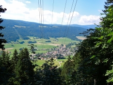
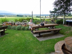
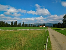
Bis Travers ging es entspannt an der Areuse entlang. Jetzt geht es erst wieder ein paar Km aufwärts mit uns, und im Auf und Ab weiter bis zur Kaffeepause in Les Ponts de Martel.
Information about copyright | |
|---|---|
Rights characteristic / license | by-sa: CREATIVE COMMONS Attribution-ShareAlike |
Link to the description of the license | |
taken over / edited on | 08 Apr 2017
|
taken over / edited by |
|
Information about copyright | |
|---|---|
Rights owner | |
Rights characteristic / license | © all rights reserved. |
Image has been uploaded | by Tandemteam-Traudel_und_Dieter on 08 Apr 2017
|
Information about copyright | |
|---|---|
Rights owner | |
Rights characteristic / license | © all rights reserved. |
Image has been uploaded | by Tandemteam-Traudel_und_Dieter on 08 Apr 2017
|
Information about copyright | |
|---|---|
Rights owner | |
Rights characteristic / license | © all rights reserved. |
Image has been uploaded | by Tandemteam-Traudel_und_Dieter on 08 Apr 2017
|
Information about copyright | |
|---|---|
Rights characteristic / license | by-sa: CREATIVE COMMONS Attribution-ShareAlike |
Link to the description of the license | |
taken over / edited on | 08 Apr 2017
|
taken over / edited by |
|
Information about copyright | |
|---|---|
Rights owner | |
Rights characteristic / license | © all rights reserved. |
Image has been uploaded | by Tandemteam-Traudel_und_Dieter on 08 Apr 2017
|
Information about copyright | |
|---|---|
Rights owner | |
Rights characteristic / license | © all rights reserved. |
Image has been uploaded | by Tandemteam-Traudel_und_Dieter on 08 Apr 2017
|
Information about copyright | |
|---|---|
Rights owner | |
Rights characteristic / license | © all rights reserved. |
Image has been uploaded | by Tandemteam-Traudel_und_Dieter on 08 Apr 2017
|