
Radtour Radurlaub entlang der Maas
Dag/day 7: Chimay-Namur
![]()
Bitte warten - Kartendaten werden geladen
Erstellt am 15.07.2021
zuletzt geändert von Ottocolor am 20.12.2022
Strecken-Merkmale
gefahren
Gesamtlänge in km
93
Gesamthöhenmeter Aufstieg
176
Durchschn. Steigung Aufstieg %
0,19
Gesamthöhenmeter Abstieg
303
min. Höhe
110
max. Höhe
253
Informationen zu Rechten an den GPS-Track-Daten | |
|---|---|
Rechte-Inhaber | |
Rechte-Ausprägung / Lizenz | cc0: Public Domain keine Rechte vorbehalten |
Link zur Rechtebeschreibung | |
gpx-Datei hochgeladen | durch Ottocolor am 15.07.2021
|
Gesamtzahl Trackpoints
1.020
Trackpoint-Dichte per km
11
Endorte
Start
Chimay, Wallonia, BE (237 m NHN)
Ziel
Namur, Wallonia, BE (110 m NHN)
gefahren am
10.07.2021
Wetter
An overcast day, before it starts to rain in the afternoon, and so it goes on for the rest of the day. Chiller, with about 20°C. The wind is still light.
Beschaffenheit
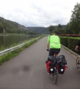
All the way from Chimay back to the river Meuse we cycle on a path called ravel (line no. 156). Ravel is the Belgian counterpart to The Green Paths of France. In this case it is an excellent disused railway track. The first part from shortly after Chimay to Mariembourg has just been opened, and the tarmac is especially smooth. At Mariembourg the path is suspended, and one has to go through the town, first on a fairly big road without a bike lane, then through the town centre, before one is back on the ravel. Down at the Meuse there's also a path along the river, which lacks between Waulsort and Anseremme. After Dinant some stretches of the path are in poor condition, and there are som cobblestone pieces. They're building the path, so there is a deviation to the other side of the river, but it's perfectly signposted, so it's easy to find our way. Shortly before the youth hostel of Namur we're back on the ravel-path along the river.
Steigungs-Verteilung
Bemerkungen
The longest stage of the bike holiday with its 93 km. But also the easiest one with the fewest altitude metres. Accommodation at the youth hostel of Namur.
Reisebericht
Informationen zu Urheber-Rechten | |
|---|---|
Rechte-Inhaber | |
Rechte-Ausprägung / Lizenz | by-sa: CREATIVE COMMONS Namensnennung, Weitergabe unter gleichen Bedingungen |
Link zur Rechtebeschreibung | |
Bild hochgeladen | durch Ottocolor am 22.07.2021
|
Informationen zu Urheber-Rechten | |
|---|---|
Rechte-Inhaber | |
Rechte-Ausprägung / Lizenz | by-sa: CREATIVE COMMONS Namensnennung, Weitergabe unter gleichen Bedingungen |
Link zur Rechtebeschreibung | |
Bild hochgeladen | durch Ottocolor am 22.07.2021
|
Informationen zu Urheber-Rechten | |
|---|---|
Rechte-Inhaber | |
Rechte-Ausprägung / Lizenz | by-sa: CREATIVE COMMONS Namensnennung, Weitergabe unter gleichen Bedingungen |
Link zur Rechtebeschreibung | |
Bild hochgeladen | durch Ottocolor am 22.07.2021
|
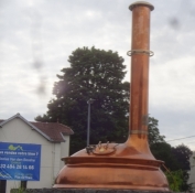
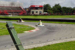
Breakfast had to be organised at a bakery, which was my job, as breakfast normally is. On my way I saw a large copper vat for beer brewing, placed in a large roundabout. They do love their beer in Chimay. From that town all the way back to the Meuse valley runs a wonderful, more than 40 km long tarmac covered wide bike trail on a disused railway line, disrupted only by the town of Mariembourg, where one has to make a detour to cross a dual carriage road and go through the town centre, but I think they're working on that. Shortly before this town we made a stop to watch a go-kart race on a race course just on the other side of the fence next to the bike trail. We really liked it! When we were back on track, which is called ravel in Belgium, my sons themselves went into racing mode. Luckily, they waited for me on the banks of the river Meuse. I must admit that the perfect bike trail slightly downhill with a tailwind invited to some racing. The next part along the river was in a lot poorer condition. On top of that i began to rain relentlessly. Between Waulsort and Anseremme there was no bike path at all, and we cycled along a medium traffic road. A setback here in Belgium. We crossed the river twice on lock installations, where there was some forth and back and up and down.
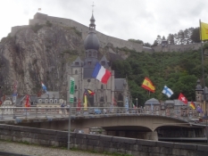
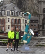
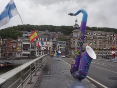
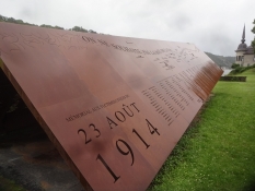
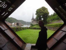
In Dinant we took a long break. First we cooked coffee under a bridge across the river and I mended one of my back panniers. Then we crossed the bridge, which is lined by two rows of giant saxophones, each one adopted by a country in the world. Dinant is the home town of the inventor of the saxophone, Adolphe Sax. A fact they make quite some noise of in this town. Its charmingly nestled on both banks of the river under steep rocks on both sides. On top of such a rocky eminence stands the fortress or citadel of Dinant. There was a fine view to to it from the other side of the river. Here we also visited the memorial of the massacre, German troops had committed on the civil population here in August 1914 out of fear for partisans, so-called franc tireurs. In general, imperial Germany committed many war crimes particularly in Belgium during WWI. This war was still ever-present on this trip.
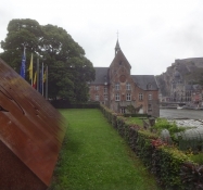
After Dinant the trail got even worse. At one place it was only a dirt track along the river. In addition, rain poured down relentlessly, so all we wanted now was to arrive at our hostel in Namur. At some other place the trail was closed due to works, but they had arranged a well-signposted detour on the other river bank. It's good they work on the conditions, which are unworthy to such a fine bicycle country like Belgium. So we grew quite hungry and tired before reaching our hostel, situated in a fine old palais on the riverbank. Unfortunately, their kitchen was corona closed. Our solution was to order pizzas (I did so in "fluent" French ;-) Afterwards we looked forward to sleep in real beds and to have a restday tomorrow.
Informationen zu Urheber-Rechten | |
|---|---|
Rechte-Ausprägung / Lizenz | by-sa: CREATIVE COMMONS Namensnennung, Weitergabe unter gleichen Bedingungen |
Link zur Rechtebeschreibung | |
übernommen / bearbeitet am | 19.12.2022 - 20.12.2022
|
übernommen / bearbeitet durch |
|
Informationen zu Urheber-Rechten | |
|---|---|
Rechte-Inhaber | |
Rechte-Ausprägung / Lizenz | by-sa: CREATIVE COMMONS Namensnennung, Weitergabe unter gleichen Bedingungen |
Link zur Rechtebeschreibung | |
Bild hochgeladen | durch Ottocolor am 22.07.2021
|
Informationen zu Urheber-Rechten | |
|---|---|
Rechte-Inhaber | |
Rechte-Ausprägung / Lizenz | by-sa: CREATIVE COMMONS Namensnennung, Weitergabe unter gleichen Bedingungen |
Link zur Rechtebeschreibung | |
Bild hochgeladen | durch Ottocolor am 22.07.2021
|
Informationen zu Urheber-Rechten | |
|---|---|
Rechte-Inhaber | |
Rechte-Ausprägung / Lizenz | by-sa: CREATIVE COMMONS Namensnennung, Weitergabe unter gleichen Bedingungen |
Link zur Rechtebeschreibung | |
Bild hochgeladen | durch am 22.07.2021
|
Informationen zu Urheber-Rechten | |
|---|---|
Rechte-Inhaber | |
Rechte-Ausprägung / Lizenz | by-sa: CREATIVE COMMONS Namensnennung, Weitergabe unter gleichen Bedingungen |
Link zur Rechtebeschreibung | |
Bild hochgeladen | durch am 22.07.2021
|
Informationen zu Urheber-Rechten | |
|---|---|
Rechte-Inhaber | |
Rechte-Ausprägung / Lizenz | by-sa: CREATIVE COMMONS Namensnennung, Weitergabe unter gleichen Bedingungen |
Link zur Rechtebeschreibung | |
Bild hochgeladen | durch am 22.07.2021
|
Informationen zu Urheber-Rechten | |
|---|---|
Rechte-Inhaber | |
Rechte-Ausprägung / Lizenz | by-sa: CREATIVE COMMONS Namensnennung, Weitergabe unter gleichen Bedingungen |
Link zur Rechtebeschreibung | |
Bild hochgeladen | durch am 22.07.2021
|