
Lahnquelle
Worth visiting
Added on 13 Nov 2013,
last edited by biroto-Redaktion on 21 Oct 2014
Nearby cycle routes and tours
| Route name | Type | Dist. to route |
|---|---|---|
Route | 0,0 km | |
Route | 0,0 km | |
Route | 2,4 km | |
Tour | 0,0 km | |
Tour | 0,0 km | |
Tour | 0,0 km | |
Tour | 0,0 km | |
Tour | 0,2 km |
![]()
Please wait - map data are loading
Type of sights
Well worth seeing landscape
Name and address
Lahnquelle
DE-57250 Netphen
GEO-data
Geodetic coordinates
50.89∎∎∎∎ 8.24∎∎∎∎
Elevation
593 m
Communication
Information about copyright | |
|---|---|
Rights owner | |
Rights characteristic / license | by-sa: CREATIVE COMMONS Attribution-ShareAlike |
Link to the description of the license | |
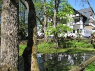
Image taken over from | commons.wikimedia.org/wiki/File:Quellteich_der_Lahn_am_Lahnhof.JPG |
Image has been uploaded | by biroto-Redaktion on 13 Nov 2013
|
Information about copyright | |
|---|---|
Rights owner | |
Rights characteristic / license | cc0: Public Domain no Rights reserved |
Link to the description of the license | |
Image taken over from | |
Image has been uploaded | by biroto-Redaktion on 13 Nov 2013
|
Information about copyright | |
|---|---|
Rights owner | |
Rights characteristic / license | by-sa: CREATIVE COMMONS Attribution-ShareAlike |
Link to the description of the license | |
Image taken over from | |
Image has been uploaded | by biroto-Redaktion on 13 Nov 2013
|
Die Lahn entspringt im südöstlichen Nordrhein-Westfalen an der Grenze zu Hessen im südöstlichen Rothaargebirge auf dem Höhenzug/NaturraumEderkopf-Lahnkopf-Rücken(333.01), auf dem dieRhein-Weser-Wasserscheideauf die Rheinsystem-interne Wasserscheide zwischen Lahn und Sieg trifft.
Ihre Quelle, der Lahntopf, befindet sich auf etwa 603 m ü. NHN südwestlich des 624,9 m hohen Lahnkopfs ![]() bei Lahnhof
bei Lahnhof ![]() , einem Ortsteil von Nenkersdorf, das wiederum ein Stadtteil von Netphen
, einem Ortsteil von Nenkersdorf, das wiederum ein Stadtteil von Netphen ![]() ist. In der näheren Umgebung entspringen außerdem die Eder
ist. In der näheren Umgebung entspringen außerdem die Eder ![]() (5,5 km nordwestlich der Lahnquelle) und die Sieg
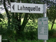
(5,5 km nordwestlich der Lahnquelle) und die Sieg ![]() (3 km nördlich derselben). Direkt am Lahnursprung vorbei führen Abschnitte des Rothaarsteigs und der Eisenstraße.
(3 km nördlich derselben). Direkt am Lahnursprung vorbei führen Abschnitte des Rothaarsteigs und der Eisenstraße.
Anfang 2013 wurde die junge Lahn im Zuge der Renaturierung unmittelbar unterhalb ihrer Quelle von einer Verrohrung unter einer Wiese auf einer Länge von 300 Metern befreit. Außerdem wurde der Quelltopf gestalterisch aufgewertet. Die Renaturierungsarbeiten wurden wie auch die bei der Siegquelle von einer Baufirma aus Wilnsdorf übernommen.
Information about copyright | |
|---|---|
Rights characteristic / license | by-sa: CREATIVE COMMONS Attribution-ShareAlike |
Link to the description of the license | |
Input taken over from: |
Seite „Lahnquelle“. In: Wikipedia, Die freie Enzyklopädie. Bearbeitungsstand: 14. Oktober 2014, 21:46 UTC. URL: http://de.wikipedia.org/w/index.php?title=Lahnquelle&oldid=134896489 (Abgerufen: 21. Oktober 2014, 15:36 UTC) |
taken over / edited on | 13 Nov 2013 - 21 Oct 2014
|
taken over / edited by |
|
Nearby cycle routes and tours
| Route name | Type | Dist. to route |
|---|---|---|
Route | 0,0 km | |
Route | 0,0 km | |
Route | 2,4 km | |
Tour | 0,0 km | |
Tour | 0,0 km | |
Tour | 0,0 km | |
Tour | 0,0 km | |
Tour | 0,2 km |
Added on 13 Nov 2013,
last edited by biroto-Redaktion on 21 Oct 2014