
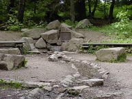
Lenne-Quelle
Worth visiting
Added on 25 Apr 2012,
last edited by biroto-Redaktion on 20 Jun 2012
Nearby cycle routes and tours
| Route name | Type | Dist. to route |
|---|---|---|
Route | 0,0 km | |
Route | 2,4 km | |
Route | 4,0 km | |
Tour | 0,3 km | |
Tour | 3,8 km |
![]()
Please wait - map data are loading
Type of sights
Well worth seeing landscape
Name and address
Lenne-Quelle
DE-59955 Winterberg
GEO-data
Geodetic coordinates
51.17∎∎∎∎ 8.48∎∎∎∎
Elevation
816 m
Communication
Information about copyright | |
|---|---|
Rights owner | |
Rights characteristic / license | by-sa: CREATIVE COMMONS Attribution-ShareAlike |
Link to the description of the license | |
Image taken over from | |
Image has been uploaded | by biroto-Redaktion on 25 Apr 2012
|
Die Lenne entspringt am Kahlen Asten ![]() , etwa 300 m westlich des 841,9 m hohen Gipfels und des darauf stehenden Aussichtsturms auf einer Höhe von 823 m ü. NN. Über den Lehrpfad Kahler Asten, der durch die Hochheide
, etwa 300 m westlich des 841,9 m hohen Gipfels und des darauf stehenden Aussichtsturms auf einer Höhe von 823 m ü. NN. Über den Lehrpfad Kahler Asten, der durch die Hochheide ![]() führt, kann man leicht zur Lennequelle gelangen.
führt, kann man leicht zur Lennequelle gelangen.
Information about copyright | |
|---|---|
Rights characteristic / license | by-sa: CREATIVE COMMONS Attribution-ShareAlike |
Link to the description of the license | |
Input taken over from: |
Seite „Lenne (Ruhr)“. In: Wikipedia, Die freie Enzyklopädie. Bearbeitungsstand: 20. April 2012, 16:50 UTC. URL: http://de.wikipedia.org/w/index.php?title=Lenne_(Ruhr)&oldid=102273643 (Abgerufen: 24. April 2012, 22:55 UTC) |
taken over / edited on | 25 Apr 2012
|
taken over / edited by |
|
Nearby cycle routes and tours
| Route name | Type | Dist. to route |
|---|---|---|
Route | 0,0 km | |
Route | 2,4 km | |
Route | 4,0 km | |
Tour | 0,3 km | |
Tour | 3,8 km |
Added on 25 Apr 2012,
last edited by biroto-Redaktion on 20 Jun 2012