
Corinth Canal
Worth visiting
Added on 03 Nov 2014,
last edited by biroto-Redaktion on 03 Nov 2014
Nearby cycle routes and tours
| Route name | Type | Dist. to route |
|---|---|---|
Route | 0,3 km | |
Route | 0,3 km |
![]()
Please wait - map data are loading
Type of sights
Industrial heritage
Name and address
Corinth Canal
GR-203 00 Gefira Isthmou
GEO-data
Geodetic coordinates
37.93∎∎∎∎ 22.98∎∎∎∎
Elevation
8 m
Communication
Information about copyright | |
|---|---|
Rights owner | |
Rights characteristic / license | cc0: Public Domain no Rights reserved |
Link to the description of the license | |
Image taken over from | |
Image has been uploaded | by biroto-Redaktion on 03 Nov 2014
|
Information about copyright | |
|---|---|
Rights owner | |
Rights characteristic / license | by-sa: CREATIVE COMMONS Attribution-ShareAlike |
Link to the description of the license | |
Image taken over from | |
Image has been uploaded | by biroto-Redaktion on 03 Nov 2014
|
Information about copyright | |
|---|---|
Rights owner | |
Rights characteristic / license | by-sa: CREATIVE COMMONS Attribution-ShareAlike |
Link to the description of the license | |
Image taken over from | |
Image has been uploaded | by biroto-Redaktion on 03 Nov 2014
|
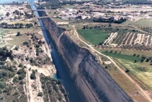
The Corinth Canal (Greek: Διώρυγα της Κορίνθου, Dhioryga tis Korinthou) is a canal that connects the Gulf of Corinth with the Saronic Gulf in the Aegean Sea. It cuts through the narrow Isthmus of Corinth and separates the Peloponnese from the Greek mainland, thus effectively making the former peninsula an island. The builders dug the canal through the Isthmus at sea level; no locks are employed. It is 6.4 kilometres (4.0 mi) in length and only 21.4 metres (70 ft) wide at its base, making it impassable for most modern ships. It now has little economic importance.
The canal was mooted in classical times and an abortive effort was made to build it in the 1st century AD. Construction finally got underway in 1881 but was hampered by geological and financial problems that bankrupted the original builders. It was completed in 1893, but due to the canal's narrowness, navigational problems and periodic closures to repair landslides from its steep walls, it failed to attract the level of traffic anticipated by its operators. It is now used mainly for tourist traffic.
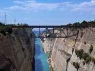
The canal consists of a single channel 8 metres (26 ft) deep, excavated at sea level (thus requiring no locks), measuring 6,346 metres (20,820 ft) long by 24.6 metres (81 ft) wide at the top and 21.3 metres (70 ft) wide at the bottom. The rock walls, which rise 90 metres (300 ft) above sea level, are at a near-vertical 80° angle. The canal is crossed by a railway line, a road and a motorway at a height of about 45 metres (148 ft). In 1988 submersible bridges were installed at sea level at each end of the canal, by the eastern harbour of Isthmia and the western harbour of Poseidonia.
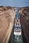
Although the canal saves the 700-kilometre (430 mi) journey around the Peloponnese, it is too narrow for modern ocean freighters, as it can only accommodate ships of a width of up to 16.5 metres (54 ft) and a draft of 7.3 metres (24 ft). Ships can only pass through the canal one at a time on a one-way system. Larger ships have to be towed by tugs. The canal is nowadays mostly used by tourist ships; 11,000 ships per year travel through the waterway.
Information about copyright | |
|---|---|
Rights characteristic / license | by-sa: CREATIVE COMMONS Attribution-ShareAlike |
Link to the description of the license | |
Input taken over from: |
Wikipedia contributors, 'Corinth Canal', Wikipedia, The Free Encyclopedia, 5 August 2014, 04:42 UTC, <http://en.wikipedia.org/w/index.php?title=Corinth_Canal&oldid=619914543> [accessed 2 November 2014] |
taken over / edited on | 03 Nov 2014
|
taken over / edited by |
|
Nearby cycle routes and tours
| Route name | Type | Dist. to route |
|---|---|---|
Route | 0,3 km | |
Route | 0,3 km |
Added on 03 Nov 2014,
last edited by biroto-Redaktion on 03 Nov 2014