
Moldau-Radweg
Nr. des Radweges 7
Aktionen
![]()
Bitte warten - Kartendaten werden geladen
Erstellt am 26.08.2013,
zuletzt geändert von biroto-Redaktion am 07.09.2023
Aktionen
Strecken-Merkmale
Gesamtlänge in km
427
Informationen zu Rechten an den GPS-Track-Daten | |
|---|---|
Rechte-Inhaber | cyklistevitani.cz & biroto-Redaktion |
Rechte-Ausprägung / Lizenz | cc0: Public Domain keine Rechte vorbehalten |
Link zur Rechtebeschreibung | |
gpx-Datei übernommen aus | https://www.cyklistevitani.cz/Prehled-cyklotras/Vltavska-stezka |
gpx-Datei hochgeladen | durch biroto-Redaktion am 07.09.2023
|
Gesamtzahl Trackpoints
7.549
Trackpoint-Dichte per km
18
Endorte
Start
Kvilda, JC, CZ (1062 m NHN)
Ziel
Mělník, ST, CZ (216 m NHN)
Wegweisung
 Der Radweg ist mit einem auf die Spitze gestellten blauen Dreieck, das auf den gelben Radwegschildern zusätzlich aufgebracht ist, durchgängig beschildert. |
|

Informations-Quellen
Reiseberichte über Fahrradtouren
06.07.2015
80 km
Eine Etappe der Tour »Donau - Moldau - Elbe« von Anwender ThimbleU
07.07.2015
102 km
Eine Etappe der Tour »Donau - Moldau - Elbe« von Anwender ThimbleU
08.07.2015
81 km
Eine Etappe der Tour »Donau - Moldau - Elbe« von Anwender ThimbleU
09.07.2015
82 km
Eine Etappe der Tour »Donau - Moldau - Elbe« von Anwender ThimbleU
11.07.2015
113 km
Eine Etappe der Tour »Donau - Moldau - Elbe« von Anwender ThimbleU
Fahrradfreundliche Unterkünfte, Sehenswertes und Infrastruktur
Name u. Anschrift
Breite / Länge
Tel.
Fax.
Mobile
Art d. Unterkunft
Radler-freund-lichkeit
Strecken-km
km zur Strecke
Höhe
0 km
0,1 km
1.053 m
0 km
0,0 km
1.035 m
33 km
0,0 km
866 m
52 km
0,1 km
727 m
62 km
0,1 km
812 m
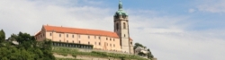
Informationen zu Urheber-Rechten | |
|---|---|
Rechte-Inhaber | |
Rechte-Ausprägung / Lizenz | by-sa: CREATIVE COMMONS Namensnennung, Weitergabe unter gleichen Bedingungen |
Link zur Rechtebeschreibung | |
Bild übernommen aus | |
Bild hochgeladen | durch biroto-Redaktion am 17.12.2012
|
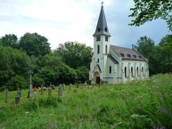
Die Gründung des Dorfes fand um 1670 statt. 1785 wurde eine Kapelle errichtet, 1788 begann der Bau einer Kirche. Mit der Gründung der Kirche wurde auch eine Schule eingerichtet. Die Kirche brannte 1876 nieder, an der Stelle wurde dann die neue gotische Kirche errichtet. Nach 1918 wurde das Dorf dem neu geschaffenen Staat Tschechoslowakei zugeschlagen. Im Zuge des Münchner Abkommens ![]() kam es 1938 mit dem Sudetenland zum Deutschen Reich. 1939 wurde es dem Landkreis Krummau an der Moldau im Reichsgau Oberdonau zugeteilt. 1945 kam Glöckelberg wieder zur Tschechoslowakei und die meisten Bewohner wurden vertrieben. Nach dem Beginn des Kalten Krieges
kam es 1938 mit dem Sudetenland zum Deutschen Reich. 1939 wurde es dem Landkreis Krummau an der Moldau im Reichsgau Oberdonau zugeteilt. 1945 kam Glöckelberg wieder zur Tschechoslowakei und die meisten Bewohner wurden vertrieben. Nach dem Beginn des Kalten Krieges ![]() wurden wegen der unmittelbarenGrenznähe die Bewohner zwangsausgesiedelt und das Dorf bis auf die Kirche geschleift.
wurden wegen der unmittelbarenGrenznähe die Bewohner zwangsausgesiedelt und das Dorf bis auf die Kirche geschleift.
Informationen zu Urheber-Rechten | |
|---|---|
Rechte-Ausprägung / Lizenz | by-sa: CREATIVE COMMONS Namensnennung, Weitergabe unter gleichen Bedingungen |
Link zur Rechtebeschreibung | |
Text(e) übernommen von: |
Seite „Zvonková“. In: Wikipedia, Die freie Enzyklopädie. Bearbeitungsstand: 10. Oktober 2012, 23:25 UTC. URL: http://de.wikipedia.org/w/index.php?title=Zvonkov%C3%A1&oldid=109178239 (Abgerufen: 17. Dezember 2012, 17:53 UTC) |
übernommen / bearbeitet am | 17.12.2012
|
übernommen / bearbeitet durch |
|
![]()