
Cycle Route Eifel-Höhen-Route
Actions
![]()
Please wait - map data are loading
Added on 04 Feb 2017,
last edited by biroto-Redaktion on 25 Nov 2020
Actions
Cycle route metrics
Total distance in km
202
Information about rights to the gps-track data | |
|---|---|
Rights owner | OpenStreetMap and Contributors + biroto-Redaktion (biroto.eu) |
Rights characteristic / license | Contains information from OpenStreetMap, which is made available here under the Open Database License(ODbL) |
Link to the description of the license | |
GPX file taken from | |
GPX file uploaded | by biroto-Redaktion on 25 Nov 2020
|
Track points in total
4.408
Track points per km (avg)
22
Start/endpoint
Start location
Monschau, Nordrhein-Westfalen, DE (419 m NHN)
End location
Monschau, Nordrhein-Westfalen, DE (418 m NHN)
Travel reports about cycle tours
Information about copyright | |
|---|---|
Rights owner | |
Rights characteristic / license | by-sa: CREATIVE COMMONS Attribution-ShareAlike |
Link to the description of the license | |
Image has been uploaded | by ihmuc on 29 Aug 2020
|
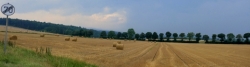
15 Aug 2020
35 km
A stage of the tour »Eifel-Höhen-Route« of user ihmuc

Information about copyright | |
|---|---|
Rights owner | |
Rights characteristic / license | by-sa: CREATIVE COMMONS Attribution-ShareAlike |
Link to the description of the license | |
Image has been uploaded | by ihmuc on 29 Aug 2020
|
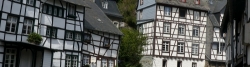
16 Aug 2020
65 km
A stage of the tour »Eifel-Höhen-Route« of user ihmuc
Information about copyright | |
|---|---|
Rights owner | |
Rights characteristic / license | by-sa: CREATIVE COMMONS Attribution-ShareAlike |
Link to the description of the license | |
Image has been uploaded | by ihmuc on 29 Aug 2020
|
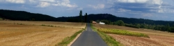
17 Aug 2020
44 km
A stage of the tour »Eifel-Höhen-Route« of user ihmuc
Information about copyright | |
|---|---|
Rights owner | |
Rights characteristic / license | by-sa: CREATIVE COMMONS Attribution-ShareAlike |
Link to the description of the license | |
Image has been uploaded | by ihmuc on 29 Aug 2020
|
18 Aug 2020
66 km
A stage of the tour »Eifel-Höhen-Route« of user ihmuc
Beds4Cyclists, worth visiting and infrastructure
Name and address
Latitude / Longitude
Phone
Fax
Mobile
Type of accommodation
Rating for cyclists
Route km
Dist. to route
Elevation
0 km
0,0 km
422 m
0 km
0,0 km
418 m
0 km
0,1 km
414 m
0 km
0,2 km
436 m
0 km
0,5 km
449 m
![]()