Cycle Route EuroVelo: Mediterranean Route Greece original routing
No. of cycle route EV8
Actions
![]()
Please wait - map data are loading
Added on 22 Oct 2014,
last edited by biroto-Redaktion on 20 Oct 2023
Actions
Cycle route metrics
Total distance in km
779
Information about rights to the gps-track data | |
|---|---|
Rights owner | |
Rights characteristic / license | cc0: Public Domain no Rights reserved |
Link to the description of the license | |
GPX file uploaded | by biroto-Redaktion on 20 Oct 2023
|
Track points in total
15.161
Track points per km (avg)
19
Start/endpoint
Start location
Αθήνα, GR (94 m NHN)
End location
Σαγιάδα, GR (136 m NHN)
Remarks
Diese Route ist Teil der EuroVelo: Mittelmeer Route - Teil Athen-Cueno.
Die hier beschriebene Route ist auf Grundlage des Konzept-Dokuments des EV8 (hier zu lesen) und des Routenverlaufs auf der Karte der Eurovelo-Seite selbst erstellt wurden.
Das Konzept-Dokument stammt aus einer frühen Planungsphase. Der seinerzeit vorgeschlagene Routenverlauf ist auf dem Abschnitt Athen bis Nafpaktos nicht mehr Bestandteil der Planungen.
Die aktuellen Planungen für den griechischen Teil des EV8 sind in dieser Route berücksichtigt.
Beds4Cyclists, worth visiting and infrastructure
Name and address
Latitude / Longitude
Phone
Fax
Mobile
Type of accommodation
Rating for cyclists
Route km
Dist. to route
Elevation
28 km
0,6 km
433 m
151 km
0,8 km
448 m
Information about copyright | |
|---|---|
Rights owner | |
Rights characteristic / license | by-sa: CREATIVE COMMONS Attribution-ShareAlike |
Link to the description of the license | |
Image taken over from | |
Image has been uploaded | by biroto-Redaktion on 23 Oct 2014
|
Information about copyright | |
|---|---|
Rights owner | |
Rights characteristic / license | by-sa: CREATIVE COMMONS Attribution-ShareAlike |
Link to the description of the license | |
Image taken over from | commons.wikimedia.org/wiki/File:Όσιος_Λουκάς_ο_εν_Στειρίω_7.JPG |
Image has been uploaded | by biroto-Redaktion on 23 Oct 2014
|
Information about copyright | |
|---|---|
Rights owner | |
Rights characteristic / license | by-sa: CREATIVE COMMONS Attribution-ShareAlike |
Link to the description of the license | |
Image taken over from | |
Image has been uploaded | by biroto-Redaktion on 23 Oct 2014
|
Information about copyright | |
|---|---|
Rights owner | |
Rights characteristic / license | by-sa: CREATIVE COMMONS Attribution-ShareAlike |
Link to the description of the license | |
Image taken over from | |
Image has been uploaded | by biroto-Redaktion on 23 Oct 2014
|
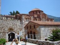
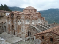
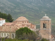
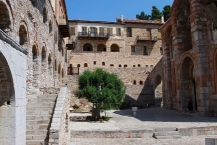
Hosios Loukas (Greek: Ὅσιος Λουκᾶς) is a historic walled monastery situated near the town of Distomo , in Boeotia, Greece. It is one of the most important monuments of Middle Byzantine architecture and art, and has been listed on UNESCO's World Heritage Sites, along with the monasteries of Nea Moni
and Daphnion
.
History
The monastery of Hosios Loukas is situated at a scenic site on the slopes of Mount Helicon . It was founded in the early 10th century AD by the hermit, Venerable (Greek: Hosios) St. Luke (Greek: Lukas), whose relics are kept in the monastery to this day. The hermit (not the Evangelist of the Gospel of Saint Luke, but a hermit who died on 7 February 953) was famous for having predicted the conquest of Crete by Emperor Romanos.
The main shrine of the monastery is the tomb of St. Luke, originally situated in the vault, but later placed at the juncture of the two churches. The monastery derived its wealth (including funds required for construction) from the fact that the relics of St. Luke were said to have exuded myron, a sort of perfumed oil which produced healing miracles. Pilgrims hoping for miraculous help were encouraged to sleep by the side of the tomb in order to be healed by incubation. The mosaics around the tomb represent not only St. Luke himself, but also hegumen Philotheos offering a likeness of the newly built church to the saint.
Architecture
The Church of the Theotokos, the oldest in the complex, is the only church known with certainty to have been built in mainland Greece in the tenth century. This centralized parallelogram-shaped building is the oldest example of the cross-in-square type in the country; its plan closely follows that of Lips Monastery in Constantinople. The walls are opus mixtum (part brick, part stone, part marble) and display curious pseudo-kufic patterns.
The Church of the Theotokos adjoins a larger cathedral church, or Katholikon, tentatively dated to 1011-12. The Katholikon is the earliest extant domed-octagon church, with eight piers arranged around the perimeter of the naos (nave). The hemispherical dome (without a drum) rests upon four squinches which make a transition from the octagonal base under the dome to the square defined by the walls below. The main cube of the church is surrounded by galleries and chapels on all four sides.
Decoration
Hosios Loukas is the largest of three monasteries surviving from the Middle Byzantine period in Greece. It differs from the Daphnion and Nea Moni in that it is dedicated to a single military saint. St. Lukes' prophecy about the reconquest of Crete is commemorated by the image of Joshua on the exterior wall of the Panagia church: Joshua was considered a model "warrior of the faith", whose help was especially effective in the wars waged against the Arabs. The Katholikon contains the best preserved complex of mosaics from the period of the Macedonian Renaissance. However, the complex is not complete: the original image of Christ Pantocrator inside the dome is missing, as are the figures of archangels normally placed between the upper windows.
There is evidence that the monastery was reputed all over Byzantium for its lavish decoration, liberally applied to all surfaces. Apart from revetment, carving, gold and silver plate, murals, and mosaics (especially imposing on curving surfaces), the interior featured a choice assortment of icons, chandeliers, silk curtains, and altar cloths. Only a fraction of these items are still in situ, most notably colored marble facings and window grilles. Notwithstanding the losses, the Katholikon "gives the best impression available anywhere today of the character of a church interior in the first centuries after the end of Iconoclasm".
Information about copyright | |
|---|---|
Rights characteristic / license | by-sa: CREATIVE COMMONS Attribution-ShareAlike |
Link to the description of the license | |
Input taken over from: |
Wikipedia contributors, 'Hosios Loukas', Wikipedia, The Free Encyclopedia, 3 September 2014, 16:50 UTC, <http://en.wikipedia.org/w/index.php?title=Hosios_Loukas&oldid=624033519> [accessed 23 October 2014] |
taken over / edited on | 23 Oct 2014
|
taken over / edited by |
|
190 km
0,2 km
577 m
Information about copyright | |
|---|---|
Rights owner | commons.wikimedia.org/w/index.php?title=User:Helen_Simonsson |
Rights characteristic / license | by-sa: CREATIVE COMMONS Attribution-ShareAlike |
Link to the description of the license | |
Image taken over from | |
Image has been uploaded | by biroto-Redaktion on 23 Oct 2014
|
Information about copyright | |
|---|---|
Rights owner | |
Rights characteristic / license | cc0: Public Domain no Rights reserved |
Link to the description of the license | |
Image taken over from | commons.wikimedia.org/wiki/File:EHGritaly_120305-09_(Theater_of_Delphi_1).JPG |
Image has been uploaded | by biroto-Redaktion on 23 Oct 2014
|
Information about copyright | |
|---|---|
Rights owner | |
Rights characteristic / license | by-sa: CREATIVE COMMONS Attribution-ShareAlike |
Link to the description of the license | |
Image taken over from | |
Image has been uploaded | by biroto-Redaktion on 23 Oct 2014
|
Information about copyright | |
|---|---|
Rights owner | |
Rights characteristic / license | by-sa: CREATIVE COMMONS Attribution-ShareAlike |
Link to the description of the license | |
Image taken over from | |
Image has been uploaded | by biroto-Redaktion on 23 Oct 2014
|
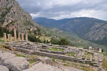
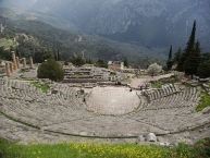
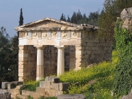
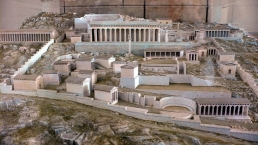
Delphi (/ˈdɛlfaɪ/ or /ˈdɛlfi/; Greek: Δελφοί, [ðelˈfi]) is both an archaeological site and a modern town in Greece on the south-western spur of Mount Parnassus in the valley of Phocis. In myths dating to the classical period of Ancient Greece (510-323 BC), the site of Delphi was believed to be determined by Zeus when he sought to find the centre of his "Grandmother Earth" (Ge, Gaea, or Gaia). He sent two eagles flying from the eastern and western extremities, and the path of the eagles crossed over Delphi where the omphalos, or navel of Gaia was found.
Earlier myths include traditions that Pythia, or the Delphic oracle, already was the site of an important oracle in the pre-classical Greek world (as early as 1400 BC) and, rededicated, served as the major site during classical times for the worship of the god Apollo after he slew Python, "a dragon" who lived there and protected the navel of the Earth. "Python" (derived from the verb pythein, "to rot") is claimed by some to be the original name of the site in recognition of Python which Apollo defeated. The Homeric Hymn to Delphic Apollo recalled that the ancient name of this site had been Krisa. Others relate that it was named Pytho and that Pythia, the priestess serving as the oracle, was chosen from their ranks by a group of priestesses who officiated at the temple.
Apollo's sacred precinct in Delphi was a panhellenic sanctuary, where every four years, starting in 586 BC athletes from all over the Greek world competed in the Pythian Games, one of the four panhellenic (or stephanitic) games, precursors of the Modern Olympics. The victors at Delphi were presented with a laurel crown (stephanos) which was ceremonially cut from a tree by a boy who re-enacted the slaying of the Python. Delphi was set apart from the other games sites because it hosted the mousikos agon, musical competitions.
These Pythian Games rank second among the four stephanitic games chronologically and based on importance. These games, though, were different from the games at Olympia in that they were not of such vast importance to the city of Delphi as the games at Olympia were to the area surrounding Olympia. Delphi would have been a renowned city whether or not it hosted these games; it had other attractions that led to it being labeled the "omphalos" (navel) of the earth, in other words, the center of the world.
In the inner hestia ("hearth") of the Temple of Apollo, an eternal flame burned. After the battle of Plataea, the Greek cities extinguished their fires and brought new fire from the hearth of Greece, at Delphi; in the foundation stories of several Greek colonies, the founding colonists were first dedicated at Delphi.
Information about copyright | |
|---|---|
Rights characteristic / license | by-sa: CREATIVE COMMONS Attribution-ShareAlike |
Link to the description of the license | |
Input taken over from: |
Wikipedia contributors, 'Delphi', Wikipedia, The Free Encyclopedia, 22 October 2014, 13:36 UTC, <http://en.wikipedia.org/w/index.php?title=Delphi&oldid=630651453> [accessed 23 October 2014] |
taken over / edited on | 23 Oct 2014
|
taken over / edited by |
|
326 km
0,1 km
3 m
Information about copyright | |
|---|---|
Rights owner | |
Rights characteristic / license | by: CREATIVE COMMONS Attribution |
Link to the description of the license | |
Image taken over from | en.wikipedia.org/wiki/File:Lepanto_naupactus_venecian_fortress.JPG |
Image has been uploaded | by biroto-Redaktion on 10 Oct 2014
|
Information about copyright | |
|---|---|
Rights owner | |
Rights characteristic / license | cc0: Public Domain no Rights reserved |
Link to the description of the license | |
Image taken over from | |
Image has been uploaded | by biroto-Redaktion on 10 Oct 2014
|
Information about copyright | |
|---|---|
Rights owner | |
Rights characteristic / license | cc0: Public Domain no Rights reserved |
Link to the description of the license | |
Image taken over from | |
Image has been uploaded | by biroto-Redaktion on 10 Oct 2014
|
Information about copyright | |
|---|---|
Rights owner | |
Rights characteristic / license | cc0: Public Domain no Rights reserved |
Link to the description of the license | |
Image taken over from | |
Image has been uploaded | by biroto-Redaktion on 10 Oct 2014
|
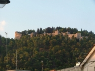
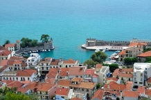
The Nafpaktos is a seaside town (altitude. 15m.) the Corinthian Gulf and belongs to the prefecture Aetoloakarnanias. Built between Antirrio and the mouth of Mornou
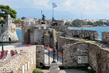
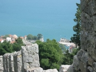
river it is one of the oldest Greek cities that experienced periods of great prosperity and was associated with significant historical events. This is confirmed by the excellent fortification, which starts from the port, continues with three walls and ends at the castle. It has been declared a traditional settlement .
Sights
- The well preserved castle which dominates the pine-covered hills above the town.
- The Venetian harbor.
- The traditional houses in the city center and the cobbled streets.
- The old family mansion Mpotsari which is converted into a private museum.
- The two city beaches Psani and Grimpovo and the beaches nearby the village of Phocis.
- The nearby Rio-Antirrio or officially Charilaos Trikoupis Bridge
.
- The museum "medicine". Museum of the national liberation struggle in 1821.
- The traditional stone lighthouse in the Castle of Nafpaktos
Information about copyright | |
|---|---|
Rights characteristic / license | by-sa: CREATIVE COMMONS Attribution-ShareAlike |
Link to the description of the license | |
Input taken over from: |
Συντάκτες της Βικιπαίδειας, 'Ναύπακτος', Βικιπαίδεια, Η Ελεύθερη Εγκυκλοπαίδεια, 31 Αυγούστου 2014, 09:55 UTC, [ανακτήθηκε 9 Οκτωβρίου 2014] |
taken over / edited on | 10 Oct 2014
|
taken over / edited by |
|
327 km
0,2 km
44 m
![]()

