
Cycle Tour Aachen - Vennbahn - Mosel - Saar - Mosel - Erft - Solingen
Tag 17: Bergheim - Solingen
![]()
Please wait - map data are loading
Added on 19 Jul 2023
last edited by ThimbleU on 04 Oct 2023
Cycle route metrics
ridden
Total distance in km
81
Cumulative elevation gain in m
397
Avg. slope uphill in %
0,49
Cumulative elevation loss in m
264
Total cycling hours
5,1
Avg. pace in km/h
15,9
Min. height
40
Max. height
200
Information about rights to the gps-track data | |
|---|---|
Rights owner | |
Rights characteristic / license | cc0: Public Domain no Rights reserved |
Link to the description of the license | |
GPX file uploaded | by ThimbleU on 21 Jul 2023
|
Track points in total
1.624
Track points per km (avg)
20
Start/endpoint
Start location
Bergheim, NW, DE (67 m NHN)
End location
Solingen, NW, DE (200 m NHN)
ridden on
20 Jul 2023
Weather
Leicht bewölkt bis wolkig, windstill. 18 bis 23°C.
Slope Gradient Distribution
Travel report
Information about copyright | |
|---|---|
Rights owner | |
Rights characteristic / license | by-sa: CREATIVE COMMONS Attribution-ShareAlike |
Link to the description of the license | |
Image has been uploaded | by ThimbleU on 28 Aug 2023
|
Information about copyright | |
|---|---|
Rights owner | |
Rights characteristic / license | by-sa: CREATIVE COMMONS Attribution-ShareAlike |
Link to the description of the license | |
Image has been uploaded | by ThimbleU on 28 Aug 2023
|
Information about copyright | |
|---|---|
Rights owner | |
Rights characteristic / license | by-sa: CREATIVE COMMONS Attribution-ShareAlike |
Link to the description of the license | |
Image has been uploaded | by ThimbleU on 28 Aug 2023
|
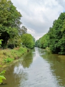
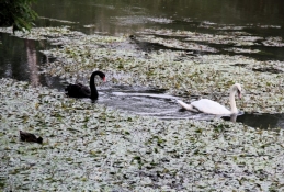
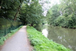
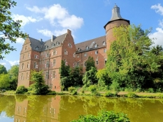
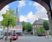
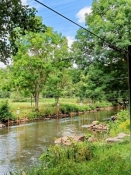
Der Weg zurück an die Erft ist schnell geschafft. Der Radweg führt am Ufer entlang. Bei Paffendorf treffen wir auf ein Schwanenpaar auf der Erft, einer schwarz, der andere weiß. In Bedburg biegen wir von der Route ab in den Schlosspark und wählen etwas unglücklich einen schmalen Pfad, der uns zunächst in die Stadtmitte führt. Schließlich stehen wir dann doch an dem wuchtigen Schlossbau.
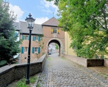
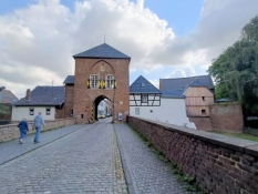
An der Erft entlang verlassen wir die Stadt und biegen kurz darauf zu einem Abstecher nach Alt-Kaster ab. Nach eineinhalb Kilometern auf einem Waldweg kommen wir an das Erfttor des befestigten Landstädtchens, das seit 1328 Stadtrechte hatte. Wir fahren die Hauptstraße hinauf bis zum Agathator und wieder zurück zum Erfttor.
Information about copyright | |
|---|---|
Rights characteristic / license | by-sa: CREATIVE COMMONS Attribution-ShareAlike |
Link to the description of the license | |
taken over / edited on | 28 Aug 2023 - 04 Oct 2023
|
taken over / edited by |
|
Information about copyright | |
|---|---|
Rights owner | |
Rights characteristic / license | by-sa: CREATIVE COMMONS Attribution-ShareAlike |
Link to the description of the license | |
Image has been uploaded | by ThimbleU on 28 Aug 2023
|
Information about copyright | |
|---|---|
Rights owner | |
Rights characteristic / license | by-sa: CREATIVE COMMONS Attribution-ShareAlike |
Link to the description of the license | |
Image has been uploaded | by ThimbleU on 28 Aug 2023
|
Information about copyright | |
|---|---|
Rights owner | |
Rights characteristic / license | by-sa: CREATIVE COMMONS Attribution-ShareAlike |
Link to the description of the license | |
Image has been uploaded | by ThimbleU on 28 Aug 2023
|
Information about copyright | |
|---|---|
Rights owner | |
Rights characteristic / license | by-sa: CREATIVE COMMONS Attribution-ShareAlike |
Link to the description of the license | |
Image has been uploaded | by ThimbleU on 28 Aug 2023
|
Information about copyright | |
|---|---|
Rights owner | |
Rights characteristic / license | by-sa: CREATIVE COMMONS Attribution-ShareAlike |
Link to the description of the license | |
Image has been uploaded | by ThimbleU on 28 Aug 2023
|
Information about copyright | |
|---|---|
Rights owner | |
Rights characteristic / license | by-sa: CREATIVE COMMONS Attribution-ShareAlike |
Link to the description of the license | |
Image has been uploaded | by ThimbleU on 28 Aug 2023
|
Information about copyright | |
|---|---|
Rights owner | |
Rights characteristic / license | by-sa: CREATIVE COMMONS Attribution-ShareAlike |
Link to the description of the license | |
Image has been uploaded | by ThimbleU on 28 Aug 2023
|
Information about copyright | |
|---|---|
Rights owner | |
Rights characteristic / license | by-sa: CREATIVE COMMONS Attribution-ShareAlike |
Link to the description of the license | |
Image has been uploaded | by ThimbleU on 28 Aug 2023
|
Information about copyright | |
|---|---|
Rights owner | |
Rights characteristic / license | by-sa: CREATIVE COMMONS Attribution-ShareAlike |
Link to the description of the license | |
Image has been uploaded | by ThimbleU on 28 Aug 2023
|
Zurück auf dem Erft-Radweg gelangen wir nach drei Kilometern in Frimmersdorf am Braunkohle-Kraftwerk vorbei, es ist in Sicherheitsbereitschaft. Es ist das erste, was wir vom Rheinischen Braunkohlerevier wahrnehmen. Und das obwohl wir schon seit Bliesheim, also rund 50 Kilometer, unweit der ehemaligen Abbaugebiete unterwegs sind.
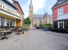
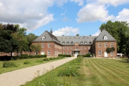
In Grevenbroich ein kurzer Abstecher in den Ortskern. Durch den Stadtpark radeln wir weiter und am Fluss entlang nach Wevelinghofen. Nach einem kurzen Stück auf Straßen fahren weiter auf Waldwegen zum Kloster Langwaden. Eine Außenbesichtigung ist möglich, die Klosterkapelle ist ebenfalls zugänglich.
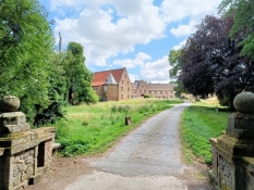
Schloss Hülchrath ist am besten während der Anfahrt auf den Ort zusehen. Wir folgen den Schildern und gelangen so an die Zufahrt zum Wirtschaftshof des Schlosses. Zugang ist nicht gestattet und nur ein Teil der Wirtschaftsgebäude ist einsehbar. Das Hochschloss steht versteckt hinter Bäumen.
Information about copyright | |
|---|---|
Rights characteristic / license | by-sa: CREATIVE COMMONS Attribution-ShareAlike |
Link to the description of the license | |
taken over / edited on | 28 Aug 2023 - 04 Oct 2023
|
taken over / edited by |
|
Information about copyright | |
|---|---|
Rights owner | |
Rights characteristic / license | by-sa: CREATIVE COMMONS Attribution-ShareAlike |
Link to the description of the license | |
Image has been uploaded | by ThimbleU on 28 Aug 2023
|
Information about copyright | |
|---|---|
Rights owner | |
Rights characteristic / license | by-sa: CREATIVE COMMONS Attribution-ShareAlike |
Link to the description of the license | |
Image has been uploaded | by ThimbleU on 28 Aug 2023
|
Information about copyright | |
|---|---|
Rights owner | |
Rights characteristic / license | by-sa: CREATIVE COMMONS Attribution-ShareAlike |
Link to the description of the license | |
Image has been uploaded | by ThimbleU on 28 Aug 2023
|
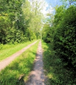
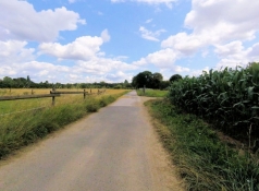
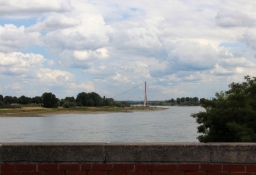
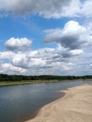
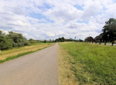
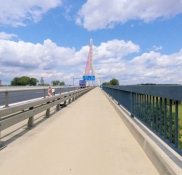
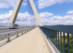
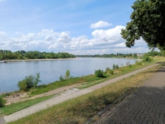
Überwiegend auf Wirtschaftswegen radeln wir weiter. Der Radweg verläuft wieder nahe an der Erft. Nach Unterquerung der Autobahnbrücke der A57 beginnt bald der Mündungsdeich. Auf der Deichkrone radeln wir bis zum Rhein. Nach einem kurzen Stück oberhalb des Rheinufers fahren wir durch den Uedesheimer Rheinbogen zur Fleher Brücke und queren an das rechte Rheinufer.
Information about copyright | |
|---|---|
Rights characteristic / license | by-sa: CREATIVE COMMONS Attribution-ShareAlike |
Link to the description of the license | |
taken over / edited on | 04 Oct 2023
|
taken over / edited by |
|
Information about copyright | |
|---|---|
Rights owner | |
Rights characteristic / license | by-sa: CREATIVE COMMONS Attribution-ShareAlike |
Link to the description of the license | |
Image has been uploaded | by ThimbleU on 28 Aug 2023
|
Information about copyright | |
|---|---|
Rights owner | |
Rights characteristic / license | by-sa: CREATIVE COMMONS Attribution-ShareAlike |
Link to the description of the license | |
Image has been uploaded | by ThimbleU on 28 Aug 2023
|
Information about copyright | |
|---|---|
Rights owner | |
Rights characteristic / license | by-sa: CREATIVE COMMONS Attribution-ShareAlike |
Link to the description of the license | |
Image has been uploaded | by ThimbleU on 28 Aug 2023
|
Information about copyright | |
|---|---|
Rights owner | |
Rights characteristic / license | by-sa: CREATIVE COMMONS Attribution-ShareAlike |
Link to the description of the license | |
Image has been uploaded | by ThimbleU on 28 Aug 2023
|
Information about copyright | |
|---|---|
Rights owner | |
Rights characteristic / license | by-sa: CREATIVE COMMONS Attribution-ShareAlike |
Link to the description of the license | |
Image has been uploaded | by ThimbleU on 28 Aug 2023
|

Information about copyright | |
|---|---|
Rights owner | |
Rights characteristic / license | by-sa: CREATIVE COMMONS Attribution-ShareAlike |
Link to the description of the license | |
Image has been uploaded | by ThimbleU on 28 Aug 2023
|
Information about copyright | |
|---|---|
Rights owner | |
Rights characteristic / license | by-sa: CREATIVE COMMONS Attribution-ShareAlike |
Link to the description of the license | |
Image has been uploaded | by ThimbleU on 28 Aug 2023
|
Information about copyright | |
|---|---|
Rights owner | |
Rights characteristic / license | by-sa: CREATIVE COMMONS Attribution-ShareAlike |
Link to the description of the license | |
Image has been uploaded | by ThimbleU on 28 Aug 2023
|
Information about copyright | |
|---|---|
Rights owner | |
Rights characteristic / license | by-sa: CREATIVE COMMONS Attribution-ShareAlike |
Link to the description of the license | |
Image has been uploaded | by ThimbleU on 28 Aug 2023
|
Information about copyright | |
|---|---|
Rights characteristic / license | by-sa: CREATIVE COMMONS Attribution-ShareAlike |
Link to the description of the license | |
taken over / edited on | 04 Oct 2023
|
taken over / edited by |
|