
Cycle Tour Bike holiday The Upper Rhine
Dag/day 2: Andermatt-Sumvitg
![]()
Please wait - map data are loading
Added on 24 Jul 2020
last edited by Ottocolor on 06 Aug 2020
Cycle route metrics
ridden
Total distance in km
25
Cumulative elevation gain in m
1.569
Avg. slope uphill in %
6,28
Cumulative elevation loss in m
1.951
Min. height
1.051
Max. height
2.709
Information about rights to the gps-track data | |
|---|---|
Rights owner | |
Rights characteristic / license | cc0: Public Domain no Rights reserved |
Link to the description of the license | |
GPX file uploaded | by Ottocolor on 24 Jul 2020
|
Track points in total
637
Track points per km (avg)
25
Start/endpoint
Start location
Andermatt, Uri, CH (1441 m NHN)
End location
Sumvitg, Graubünden, CH (1059 m NHN)
ridden on
09 Jul 2020
Weather
Warm and sunny weather all day. Even at an altitude og 2,500 m the air is warm.
Accommodation
Camping Garvera
Via Staziun
CH-7175 Sumvitg
Properties
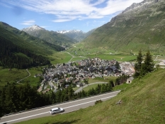
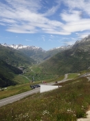
The route from the Oberalp pass to Disentis runs on main road 19, steeply descending in the traffic. At Disentis the separate bike route through the valley of the Rhine Anterior begins, but technical problems and a blocked road make us take the train from Disentis to Sumvitg Cumpadials.
Slope Gradient Distribution
Remarks
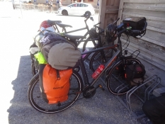
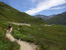
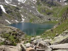
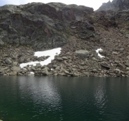
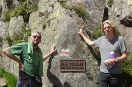
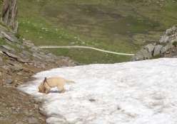
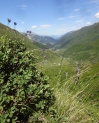
Not a day without any problems. First we take the train from Andermatt to the Oberalp pass in order to skip the 600 altidude meters on the 11 km stretch. Then we venture on a long mountain walk to the Toma lake, which is said to be the Rhine's source. Alexander and Simon even hike on via the mountain top of Pazolastock. I fall twice down a mountain slope on my way back. Simon gets problems with his brakes on the descent from the Oberalp pass. Plus his left rear pannier ends up in his rear wheel. The first part of the bike route through the valley is blocked, so Alexander and I follow him on a train ride the last bit of todays stage.
Travel report
Information about copyright | |
|---|---|
Rights owner | |
Rights characteristic / license | by-sa: CREATIVE COMMONS Attribution-ShareAlike |
Link to the description of the license | |
Image has been uploaded | by Ottocolor on 04 Aug 2020
|
Information about copyright | |
|---|---|
Rights owner | |
Rights characteristic / license | by-sa: CREATIVE COMMONS Attribution-ShareAlike |
Link to the description of the license | |
Image has been uploaded | by Ottocolor on 04 Aug 2020
|
Information about copyright | |
|---|---|
Rights owner | |
Rights characteristic / license | by-sa: CREATIVE COMMONS Attribution-ShareAlike |
Link to the description of the license | |
Image has been uploaded | by Ottocolor on 04 Aug 2020
|
Information about copyright | |
|---|---|
Rights owner | |
Rights characteristic / license | by-sa: CREATIVE COMMONS Attribution-ShareAlike |
Link to the description of the license | |
Image has been uploaded | by Ottocolor on 04 Aug 2020
|
Information about copyright | |
|---|---|
Rights owner | |
Rights characteristic / license | by-sa: CREATIVE COMMONS Attribution-ShareAlike |
Link to the description of the license | |
Image has been uploaded | by Ottocolor on 04 Aug 2020
|
Information about copyright | |
|---|---|
Rights owner | |
Rights characteristic / license | by-sa: CREATIVE COMMONS Attribution-ShareAlike |
Link to the description of the license | |
Image has been uploaded | by Ottocolor on 04 Aug 2020
|
Information about copyright | |
|---|---|
Rights owner | |
Rights characteristic / license | by-sa: CREATIVE COMMONS Attribution-ShareAlike |
Link to the description of the license | |
Image has been uploaded | by Ottocolor on 04 Aug 2020
|
Information about copyright | |
|---|---|
Rights owner | |
Rights characteristic / license | by-sa: CREATIVE COMMONS Attribution-ShareAlike |
Link to the description of the license | |
Image has been uploaded | by Ottocolor on 04 Aug 2020
|
Information about copyright | |
|---|---|
Rights owner | |
Rights characteristic / license | by-sa: CREATIVE COMMONS Attribution-ShareAlike |
Link to the description of the license | |
Image has been uploaded | by Ottocolor on 04 Aug 2020
|