
Radtour Canal des 2 mers - Mittelmeer-Route - Radroute Schweiz-Mittelmeer
7. Etappe: Agde - Aigues-Mortes
![]()
Bitte warten - Kartendaten werden geladen
Erstellt am 13.06.2018
zuletzt geändert von ThimbleU am 06.09.2018
Strecken-Merkmale
gefahren
Gesamtlänge in km
91
Gesamthöhenmeter Aufstieg
245
Durchschn. Steigung Aufstieg %
0,27
Gesamthöhenmeter Abstieg
256
Gesamtsattelstunden
5,6
Durchschnittsgeschwindigkeit in km/Std.
16,3
Informationen zu Rechten an den GPS-Track-Daten | |
|---|---|
Rechte-Inhaber | |
Rechte-Ausprägung / Lizenz | cc0: Public Domain keine Rechte vorbehalten |
Link zur Rechtebeschreibung | |
gpx-Datei hochgeladen | durch ThimbleU am 14.07.2018
|
Gesamtzahl Trackpoints
1.475
Trackpoint-Dichte per km
16
Endorte
Start
Agde, Occitania, FR (19 m NHN)
Ziel
Aigues-Mortes, Occitania, FR (8 m NHN)
gefahren am
24.06.2018
Wetter
sonnig
Unterkunft
Hôtel Canal
440 route de nîmes
FR-30220 Aigues-Mortes
Wegweisung
Bis Sète: Keine Beschilderung mit Bezug zum EuroVelo 8 oder Canal des 2 mers. |
|
Ab Ortsausgang Sète bis Aigues-Mortes beschildert als EuroVelo 8 und EuroVelo 17 sowie ViaRhôna, jedoch nicht immer ausreichend für die Navigation. |
|


Beschaffenheit
Asphalt | 87,7 km | 96,2 % |
wassergeb. schlecht | 0,5 km | 0,5 % |
Feldweg schlecht | 0,3 km | 0,3 % |
Betonplattenweg schlecht, | 2,7 km | 3,0 % |
Die Angaben beziehen sich auf die gefahrene Strecke!
Steigungs-Verteilung
Reisebericht
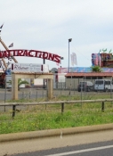
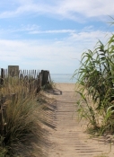
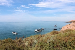
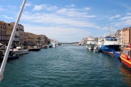
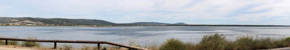
Die Fahrt aus Agde zum Radweg war einfach und wenig verkehrsreich. Dann sind wir an der D612 auf einer durch eine Betonleitplanke abgegrenzte Radwegspur entlang geradelt. Rechts von uns die ersten Brachwasserflächen. Wenig später fängt die touristische Infrastruktur an: Campingplätze, Wohnwagenpark, mehrstöckige „Parkeinrichtungen“ für Motorboote, …. Am Ende von Marseillan-Plage beginnt ein schöner Radweg nah an der Seedüne. Nach eineinhalb Kilometern beginnen auf der linken Seite Campingplätze und Ferienhaussiedlungen, 1½ Kilometer ziehen sich diese. Auf diesem Stück ein reger Fußgängerverkehr quer zur Fahrtrichtung, die Urlauber wollen zum Strand. Die nächsten sieben Kilometer alle knapp 100 Meter ein Übergang vom Radweg zum Strand. Mit zunehmender Annäherung an Sète wird der Radweg immer mehr zum Fußgängerbereich. Kurz nach Beginn der Bebauung in Sète hört der schöne Radweg auf, wir schwimmen im Verkehr mit. Es geht kurz den Hügel hinauf, und sogleich wieder hinunter. Am Hafen von Sète reihen sich die Restaurants aneinander. Im Hafenbecken einige recht große Fischerei-Schiffe.
Informationen zu Urheber-Rechten | |
|---|---|
Rechte-Ausprägung / Lizenz | by-sa: CREATIVE COMMONS Namensnennung, Weitergabe unter gleichen Bedingungen |
Link zur Rechtebeschreibung | |
übernommen / bearbeitet am | 25.06.2018 - 31.08.2018
|
übernommen / bearbeitet durch |
|
Informationen zu Urheber-Rechten | |
|---|---|
Rechte-Inhaber | |
Rechte-Ausprägung / Lizenz | © Alle Rechte vorbehalten. |
Bild hochgeladen | durch ThimbleU am 31.08.2018
|
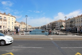
Dank des vorbereiteten Tracks ist das Navigieren in Sète durch die Einbahnstraßen unproblematisch.
Am Quai des Moulins sind wir dann weitgehend von den Autos weg. Am Ende dieser Straße dann die erste Radwegweisung: EV8 und EV17 sowie ViaRhona sind ausgeschildert. Für fast einen Kilometer wieder ein guter Radweg. Wir sind hier fast allein unterwegs.
Am Kanal 500 Meter schlechter Weg, bevor wir auf die kleine Nebenstraße nach Frontignan kommen. Diese lässt sich gut fahren, überwiegend ist ein abgegrenzter Radwegstreifen vorhanden.
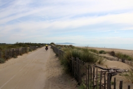
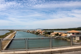
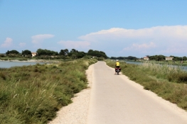
In Frontignan durch Nebenstraßen zum Kanal, über die Kanalbrücke und, ohne Wegweiser, links unter der Eisenbahnstrecke durch. Dort beginnt der gut ausgebaute Radweg, der bis Vic-la-Gardiole geht.
Informationen zu Urheber-Rechten | |
|---|---|
Rechte-Ausprägung / Lizenz | by-sa: CREATIVE COMMONS Namensnennung, Weitergabe unter gleichen Bedingungen |
Link zur Rechtebeschreibung | |
übernommen / bearbeitet am | 31.08.2018
|
übernommen / bearbeitet durch |
|
Informationen zu Urheber-Rechten | |
|---|---|
Rechte-Inhaber | |
Rechte-Ausprägung / Lizenz | © Alle Rechte vorbehalten. |
Bild hochgeladen | durch ThimbleU am 31.08.2018
|
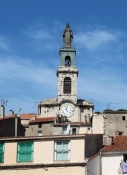
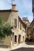
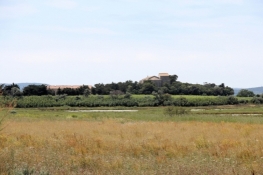
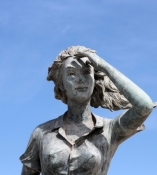
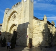
In Vic ist ein Abstecher in den kleinen mittelalterlichen Ortskern lohnend. Um die befestigte Kirche Sainte-Léocadie herum schöne kleine Gässchen und der „Boulevard“ des Ortes.
Informationen zu Urheber-Rechten | |
|---|---|
Rechte-Ausprägung / Lizenz | by-sa: CREATIVE COMMONS Namensnennung, Weitergabe unter gleichen Bedingungen |
Link zur Rechtebeschreibung | |
übernommen / bearbeitet am | 31.08.2018
|
übernommen / bearbeitet durch |
|
Informationen zu Urheber-Rechten | |
|---|---|
Rechte-Inhaber | |
Rechte-Ausprägung / Lizenz | © Alle Rechte vorbehalten. |
Bild hochgeladen | durch ThimbleU am 31.08.2018
|
Informationen zu Urheber-Rechten | |
|---|---|
Rechte-Inhaber | |
Rechte-Ausprägung / Lizenz | © Alle Rechte vorbehalten. |
Bild hochgeladen | durch ThimbleU am 01.09.2018
|
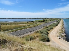
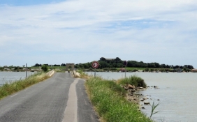
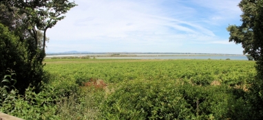
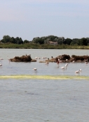
Jenseits der Eisenbahnstrecke führt der Radweg verkehrsarm über Mireval nach Villeneuve-de-Maguelone. Hier sind wir aufgrund fehlender oder übersehener Beschilderung dem gut ausgebauten Radweg in den Ort gefolgt. Und weiter geradelt bis Maguelone.
Hinweis: Auf dem Weg nach Maguelone sind zwei Einschränkungen zu erwähnen: die Brücke über den Canal du Rhône à Sète ist nur von 8:00 Uhr bis 20:30 Uhr geöffnet, Fahrräder dürfen nur geschoben werden UND nach Maguelone geht es drei Treppenabsätze hinauf, ein Schiebestreifen für die Fahrräder ist vorhanden, der ist aber steil. |
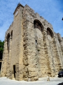
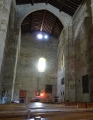
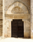
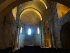
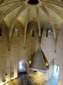
Die ehemalige Bischofskirche Maguelone konnten wir besichtigen. Sehr dunkel im Inneren, aber trotz fehlender Ausstattung ein eindrucksvolles Zeugnis der Baukunst des 11-ten und 12-ten Jhdts.
Informationen zu Urheber-Rechten | |
|---|---|
Rechte-Ausprägung / Lizenz | by-sa: CREATIVE COMMONS Namensnennung, Weitergabe unter gleichen Bedingungen |
Link zur Rechtebeschreibung | |
übernommen / bearbeitet am | 31.08.2018 - 06.09.2018
|
übernommen / bearbeitet durch |
|
Informationen zu Urheber-Rechten | |
|---|---|
Rechte-Inhaber | |
Rechte-Ausprägung / Lizenz | © Alle Rechte vorbehalten. |
Bild hochgeladen | durch ThimbleU am 01.09.2018
|
Informationen zu Urheber-Rechten | |
|---|---|
Rechte-Inhaber | |
Rechte-Ausprägung / Lizenz | © Alle Rechte vorbehalten. |
Bild hochgeladen | durch ThimbleU am 31.08.2018
|
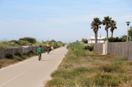
Auf der Straße am Strand entlang gelangen wir nach Palavas. Dort treffen an der D62E2 wieder auf den Radweg, der gut ausgebaut bis Carnon-Plage führt.
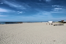
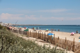
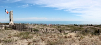
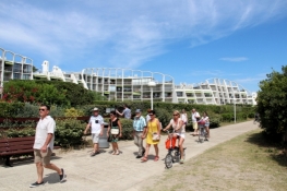
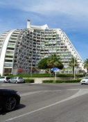
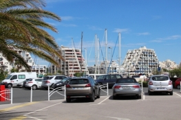
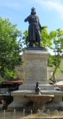
In Carnon-Plage am "Canal du Rhône à Sète" ein unglücklich eingerichtetes Hinweisschild, das uns auf schottriger Straße zu einem Sperrschild führt. Wenig weiter führt uns ein weiterer Hinweis in Richtung Tourist-Information. Auch dort kehren wir um und radeln schließlich auf dem geplanten Track bis zum Ortsende. Dort geht es auf dem gut ausgebauten Radweg durch die Dünen weiter. Der geht über in den Strandweg von La Grande Motte. Dieser ist jedoch voller Urlauber, die vom Strand zu ihren Autos strömen oder umgekehrt. Es ist viel Vorsicht geboten, um dazwischen hindurch zu kommen. Am Kreisel zur D59 fahren wir, abweichend vom offiziellen Radweg, geradeaus auf die Strandpromenade von La Grande Motte. Betonplatten in unebener Ausführung schütteln uns durch. Fußgänger sind auch reichlich unterwegs. Links von uns die für Grande Motte typischen Bauten. Vor dem Hafen biegen wir weg vom Strand und radeln ein Stück auf Straßen durch den Ort. Dann durch parkähnliches Gelände wieder auf Betonplatten, teilweise mit Rillen in Fahrtrichtung, die in Reifenbreite gefährlich tief sind.
Informationen zu Urheber-Rechten | |
|---|---|
Rechte-Ausprägung / Lizenz | by-sa: CREATIVE COMMONS Namensnennung, Weitergabe unter gleichen Bedingungen |
Link zur Rechtebeschreibung | |
übernommen / bearbeitet am | 31.08.2018 - 01.09.2018
|
übernommen / bearbeitet durch |
|
Informationen zu Urheber-Rechten | |
|---|---|
Rechte-Inhaber | |
Rechte-Ausprägung / Lizenz | © Alle Rechte vorbehalten. |
Bild hochgeladen | durch ThimbleU am 01.09.2018
|
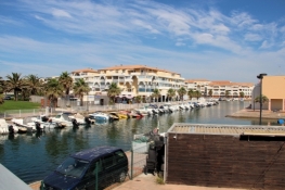
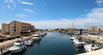
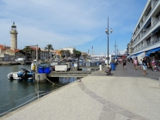
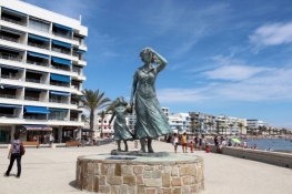
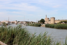
Zurück auf der Straße verläuft der Radweg neben der D255 auf eigenem Asphaltstreifen bis nach Grau-du-Roi. Dort geht es innerorts auf Einbahnstraßen weiter. Hinter der Brücke über den Canal du Rhône à Sète schieben wir die Räder durch die Altstadtgassen. Es wimmelt von Besuchern, die sich an Restaurants und Geschäften vorbeischieben.
Informationen zu Urheber-Rechten | |
|---|---|
Rechte-Ausprägung / Lizenz | by-sa: CREATIVE COMMONS Namensnennung, Weitergabe unter gleichen Bedingungen |
Link zur Rechtebeschreibung | |
übernommen / bearbeitet am | 01.09.2018
|
übernommen / bearbeitet durch |
|
Informationen zu Urheber-Rechten | |
|---|---|
Rechte-Inhaber | |
Rechte-Ausprägung / Lizenz | © Alle Rechte vorbehalten. |
Bild hochgeladen | durch ThimbleU am 01.09.2018
|
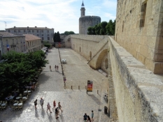
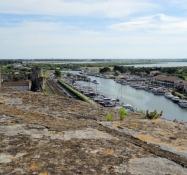
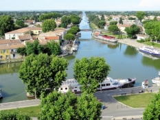
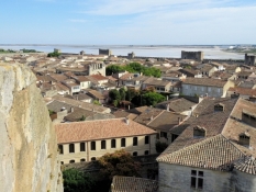
Hinter Grau-du-Roi ist der Radweg wieder hervorragend ausgebaut. Mit Rückenwind sind wir flott in Aigues-Mortes und dort am Hotel.
Informationen zu Urheber-Rechten | |
|---|---|
Rechte-Ausprägung / Lizenz | by-sa: CREATIVE COMMONS Namensnennung, Weitergabe unter gleichen Bedingungen |
Link zur Rechtebeschreibung | |
übernommen / bearbeitet am | 01.09.2018
|
übernommen / bearbeitet durch |
|
Informationen zu Urheber-Rechten | |
|---|---|
Rechte-Inhaber | |
Rechte-Ausprägung / Lizenz | © Alle Rechte vorbehalten. |
Bild hochgeladen | durch ThimbleU am 01.09.2018
|
Informationen zu Urheber-Rechten | |
|---|---|
Rechte-Inhaber | |
Rechte-Ausprägung / Lizenz | © Alle Rechte vorbehalten. |
Bild hochgeladen | durch ThimbleU am 01.09.2018
|
Informationen zu Urheber-Rechten | |
|---|---|
Rechte-Inhaber | |
Rechte-Ausprägung / Lizenz | © Alle Rechte vorbehalten. |
Bild hochgeladen | durch ThimbleU am 01.09.2018
|
Informationen zu Urheber-Rechten | |
|---|---|
Rechte-Inhaber | |
Rechte-Ausprägung / Lizenz | © Alle Rechte vorbehalten. |
Bild hochgeladen | durch ThimbleU am 01.09.2018
|
Informationen zu Urheber-Rechten | |
|---|---|
Rechte-Inhaber | |
Rechte-Ausprägung / Lizenz | © Alle Rechte vorbehalten. |
Bild hochgeladen | durch ThimbleU am 01.09.2018
|
Informationen zu Urheber-Rechten | |
|---|---|
Rechte-Inhaber | |
Rechte-Ausprägung / Lizenz | © Alle Rechte vorbehalten. |
Bild hochgeladen | durch ThimbleU am 01.09.2018
|
Informationen zu Urheber-Rechten | |
|---|---|
Rechte-Inhaber | |
Rechte-Ausprägung / Lizenz | © Alle Rechte vorbehalten. |
Bild hochgeladen | durch ThimbleU am 01.09.2018
|
Informationen zu Urheber-Rechten | |
|---|---|
Rechte-Inhaber | |
Rechte-Ausprägung / Lizenz | © Alle Rechte vorbehalten. |
Bild hochgeladen | durch ThimbleU am 03.09.2018
|
Informationen zu Urheber-Rechten | |
|---|---|
Rechte-Inhaber | |
Rechte-Ausprägung / Lizenz | © Alle Rechte vorbehalten. |
Bild hochgeladen | durch ThimbleU am 03.09.2018
|