
Cycle Tour Five-Rivers-Cycle-Route
Tag 2: Neumarkt - Bad Abbach
![]()
Please wait - map data are loading
Added on 03 Apr 2014
last edited by ThimbleU on 12 Apr 2014
Cycle route metrics
ridden
Total distance in km
99
Cumulative elevation gain in m
535
Avg. slope uphill in %
0,54
Cumulative elevation loss in m
613
Total cycling hours
6,0
Avg. pace in km/h
16,5
Min. height
334
Max. height
425
Information about rights to the gps-track data | |
|---|---|
Rights owner | |
Rights characteristic / license | by-sa: CREATIVE COMMONS Attribution-ShareAlike |
Link to the description of the license | |
GPX file uploaded | by ThimbleU on 04 Apr 2014
|
Track points in total
1.475
Track points per km (avg)
15
Start/endpoint
Start location
Neumarkt i.d.OPf., Bayern, DE (423 m NHN)
End location
Bad Abbach, Bayern, DE (335 m NHN)
ridden on
04 Apr 2014
Weather
Partly sunny, max. 22°C
Accommodation
Hotel Gasthof Zur Post
Am Markt 21
DE-93077 Bad Abbach
Signposting
Between Neumarkt and Beilngries we see no signpostings of the "Five Rivers Cycle Route", as well as on the section along the Danube. | |
Instead, the cycle route is signposted with the signpost in green and labeled "König-Ludwig-Kanal-Radweg". |
|

Properties
A water-bound surface good driveable up Pollanten, then predominantly asphalted up Kelheim. On the Danube Cycle Path water-bound surface moderately good driveable, partly gravelly.
Slope Gradient Distribution
Travel report
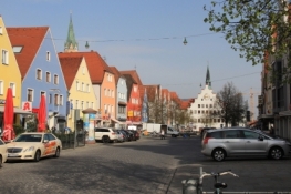
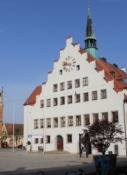
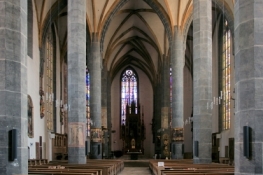
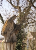
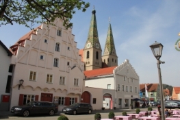
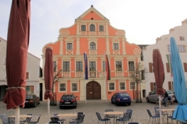
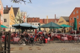
We start the day with a little sightseeing in Neumarkt: the marketplace with its color painted facades of the houses and the town hall with crenellated gable. Next to the square is the parish church of St. John, which takes effect with a rather simple interior.
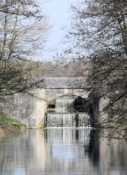
The exit from the city is a little complicated, but not a problem with GPS. But the right way on the canal we did not find.
Tip: To re-enter the cycle path along the canal, the orientation itself is a bit difficult even with Navi. There are three paths leading along the canal. Two on the embankments next to the canal and one left on the towpath in direction of travel. The towpath is the cycle route. |
After two kilometres we are back on the cycle route.
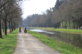
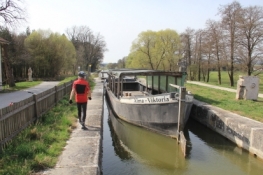
The cycle route continues along the towpath. At the canal lock 25 the "Alma Victoria" is lying, a barge as it formerly was used on the King-Ludwig-Canal. Nowadays it is used for excursions on the canal. Next we ride on the towpath to Pollanten. From there it is only a short distance to Berching.
Information about copyright | |
|---|---|
Rights characteristic / license | by-sa: CREATIVE COMMONS Attribution-ShareAlike |
Link to the description of the license | |
taken over / edited on | 12 Apr 2014
|
taken over / edited by |
|
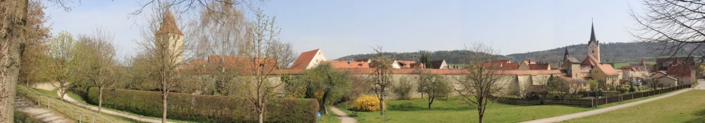
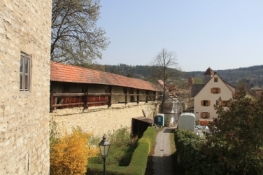
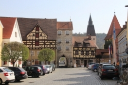
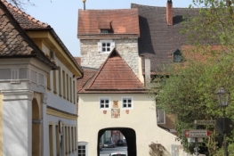
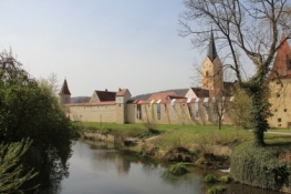
Berching ist eine Kleinstadt, in der sich ein Stück Mittelalter erhalten hat. Der Ort ist noch komplett von einer Stadtmauer umschlossen, innerhalb derer die alte Struktur ebenfalls bewahrt ist. Wir sehen uns den Ort ausführlich an.
Information about copyright | |
|---|---|
Rights characteristic / license | by-sa: CREATIVE COMMONS Attribution-ShareAlike |
Link to the description of the license | |
taken over / edited on | 08 Apr 2014 - 11 Apr 2014
|
taken over / edited by |
|
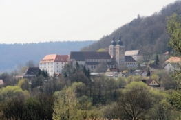
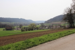
Wenige Kilometer weiter erreichen wir das Kloster Plankstetten, das schon von der gegenüberliegenden Talseite gut zu sehen war. Die Straße führt am Hang entlang und der Ausblick geht über das weite Tal in Richtung Beilngries. Auf dem Weg dorthin kommen wir an den "neuen" Main-Donau-Kanal.
Information about copyright | |
|---|---|
Rights characteristic / license | by-sa: CREATIVE COMMONS Attribution-ShareAlike |
Link to the description of the license | |
taken over / edited on | 08 Apr 2014 - 11 Apr 2014
|
taken over / edited by |
|
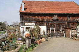
Berching ist hübsch, kann aber im Vergleich nicht mithalten. Hinter der Stadt wechselt der Radweg auf die andere Seite des Altmühl-Tales und führt am Flugplatz vorbei nach Dietfurt. Hinter Dietfurt ist ein kleiner Anstieg zu nehmen, um danach wieder hinunter zu rollen. In Mühlbach machen wir Rast neben einem Bäckerladen. Gegenüber befindet sich das Basterl-Stüberl, eine mit Bastelbedarf aus Natur und ... reichlich ausgestattete ehemalige Scheune, die einladend anzusehen ist.
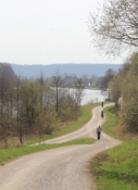
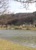
Kurz darauf kommen wir wieder an die Altmühl, in die bei Dietfurt der neue Main-Donau-Kanal aufgegangen ist. Der Radweg folgt Fluß und Kanal.
Information about copyright | |
|---|---|
Rights characteristic / license | by-sa: CREATIVE COMMONS Attribution-ShareAlike |
Link to the description of the license | |
taken over / edited on | 08 Apr 2014 - 11 Apr 2014
|
taken over / edited by |
|
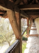
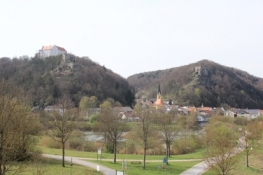
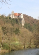
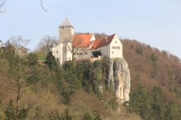
Die Rosenburg und die Ruine Tachenstein über der Stadt Riedenburg kommen ins Blickfeld. Je näher wir kommen, umso beindruckender klebt die Ruine hoch über uns in den Felsen. Leider haben wir versäumt, einen Abstecher zum Markt zu unternehmen. Stattdessen sind wir auf der Hauptstraße durch den Ort geradelt. Von der Brücke, über die wir hinter dem Ort auf die andere Talseite gequert sind, hat sich nochmals ein schöner Blick zurück auf Riedenburg und die den Ort überragende Burg und Ruine ergeben.
Drei Kilometer weiter nähern wir uns der Burg Prunn, die bereits aus einiger Entfernung auf dem steil abfallenden Kalkfelsen über dem Tal thront. Dieser Blick ist wohl mit Recht das Symbolbild des Altmühl-Tales.
Information about copyright | |
|---|---|
Rights characteristic / license | by-sa: CREATIVE COMMONS Attribution-ShareAlike |
Link to the description of the license | |
taken over / edited on | 08 Apr 2014 - 11 Apr 2014
|
taken over / edited by |
|
Bis zur Donau sind es noch 12 Kilometer, die der Radweg weiter nah an der Altmühl verläuft.
Kelheim ist die erste Stadt, die wir an der Donau erreichen. Die Altstadt ist einladend, Teile der Stadtbefestigung sind noch erhalten. Kelheim ist Sitz der Weißbierbrauerei Schneider, deren Betrieb direkt östlich der Altstadt liegt.
Information about copyright | |
|---|---|
Rights characteristic / license | by-sa: CREATIVE COMMONS Attribution-ShareAlike |
Link to the description of the license | |
taken over / edited on | 11 Apr 2014
|
taken over / edited by |
|
Am linken Donau-Ufer entlang führt der Radweg, teilweise mit verbesserungsbedürftiger Oberfläche, bis nach Poikam, dort queren wir auf das südliche Ufer und erreichen nach weiteren vier Kilometern Bad Abbach.
Information about copyright | |
|---|---|
Rights characteristic / license | by-sa: CREATIVE COMMONS Attribution-ShareAlike |
Link to the description of the license | |
taken over / edited on | 11 Apr 2014
|
taken over / edited by |
|