
Cycle Route EuroVelo: Eastern Europe Route - Part Krakow-Athens
No. of cycle route EV11
Actions
![]()
Please wait - map data are loading
Added on 31 Mar 2013,
last edited by biroto-Redaktion on 09 Nov 2023
Actions
Cycle route metrics
Total distance in km
2.834
Information about rights to the gps-track data | |
|---|---|
Rights owner | OpenStreetMap and Contributors + biroto-Redaktion (biroto.eu) |
Rights characteristic / license | Contains information from OpenStreetMap, which is made available here under the Open Database License(ODbL) |
Link to the description of the license | |
GPX file taken from | |
GPX file uploaded | by biroto-Redaktion on 09 Nov 2023
|
Track points in total
32.432
Track points per km (avg)
11
Start/endpoint
Start location
Warszawa, PL (81 m NHN)
End location
Αθήνα, GR (73 m NHN)
Signposting
In Ungarn sind am Radweg sehr vereinzelt Schilder zu finden, jedoch bei weitem nicht ausreichend für die Navigation. |
|
|


Sources of information
Connecting cycle path
Further part of the Eastern Europe Route (EV11)
Remarks
The route described here is compiled based on the route as published by EuroVelo (as of Nov. 2019). In doing so, parts of the EV11 published in OpenCycleMap and routes of the national or regional cycling networks were taken into account. If sections of the course as published at EuroVelo do not follow existing cycle routes, these sections have been filled up by self-created tracks.
Travel reports about cycle tours
03 Jun 2016
113 km
A stage of the tour »Spittal - Szeged - Cracow« of user ThimbleU
Information about copyright | |
|---|---|
Rights owner | |
Rights characteristic / license | © all rights reserved. |
Image has been uploaded | by ThimbleU on 20 Jun 2016
|
02 Jun 2016
103 km
A stage of the tour »Spittal - Szeged - Cracow« of user ThimbleU
Information about copyright | |
|---|---|
Rights owner | |
Rights characteristic / license | © all rights reserved. |
Image has been uploaded | by ThimbleU on 20 Jun 2016
|
01 Jun 2016
101 km
A stage of the tour »Spittal - Szeged - Cracow« of user ThimbleU
31 May 2016
79 km
A stage of the tour »Spittal - Szeged - Cracow« of user ThimbleU
30 May 2016
76 km
A stage of the tour »Spittal - Szeged - Cracow« of user ThimbleU
29 May 2016
96 km
A stage of the tour »Spittal - Szeged - Cracow« of user ThimbleU
Beds4Cyclists, worth visiting and infrastructure
Name and address
Latitude / Longitude
Phone
Fax
Mobile
Type of accommodation
Rating for cyclists
Route km
Dist. to route
Elevation
0 km
1,4 km
106 m
0 km
1,6 km
Information about copyright | |
|---|---|
Rights owner | |
Rights characteristic / license | by-sa: CREATIVE COMMONS Attribution-ShareAlike |
Link to the description of the license | |
Image taken over from | https://commons.wikimedia.org/wiki/File:Castle_Square,_Warsaw.jpg |
Image has been uploaded | by biroto-Redaktion on 01 Dec 2015
|
Information about copyright | |
|---|---|
Rights owner | |
Rights characteristic / license | by-sa: CREATIVE COMMONS Attribution-ShareAlike |
Link to the description of the license | |
Image taken over from | https://commons.wikimedia.org/wiki/File:POL_Old_market_square.jpg |
Image has been uploaded | by biroto-Redaktion on 01 Dec 2015
|
Information about copyright | |
|---|---|
Rights owner | https://commons.wikimedia.org/wiki/Category:Marek_and_Ewa_Wojciechowscy |
Rights characteristic / license | by-sa: CREATIVE COMMONS Attribution-ShareAlike |
Link to the description of the license | |
Image taken over from | |
Image has been uploaded | by biroto-Redaktion on 01 Dec 2015
|
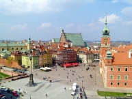
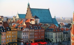
The Warsaw Old Town (Polish: Stare Miasto, and collectively with the New Town, known colloquially as: Starówka) is the oldest part of the capital city. It is bounded by the Wybrzeże Gdańskie, along with the bank of Vistula river ![]() , Grodzka, Mostowa and Podwale Streets. It is one of the most prominent tourist attractions in Warsaw
, Grodzka, Mostowa and Podwale Streets. It is one of the most prominent tourist attractions in Warsaw ![]() .
.
Warsaw's Old Town has been placed on the UNESCO's list of World Heritage Sites as "an outstanding example of a near-total reconstruction of a span of history covering the 13th to the 20th century.
The heart of the area is the Old Town Market Place ![]() , rich in restaurants, cafés and shops. Surrounding streets feature medieval architecture such as the city walls, the Barbican
, rich in restaurants, cafés and shops. Surrounding streets feature medieval architecture such as the city walls, the Barbican ![]() and St. John's Cathedral
and St. John's Cathedral ![]() .
.
History
The Old Town was established in the 13th century. Initially surrounded by an earthwork rampart, prior to 1339 it was fortified with brick city walls. The town originally grew up around the castle of the Dukes of Mazovia that later became the Royal Castle ![]() . The Market Square (Rynek Starego Miasta) was laid out sometime in the late 13th or early 14th century, along the main road linking the castle with the New Town
. The Market Square (Rynek Starego Miasta) was laid out sometime in the late 13th or early 14th century, along the main road linking the castle with the New Town ![]() to the north.
to the north.
Until 1817 the Old Town's most notable feature was the Town Hall built before 1429. In 1701 the square was rebuilt by Tylman Gamerski, and in 1817 the Town Hall was demolished.
In the early 1910s Warsaw Old Town was the home of the prominent Yiddish writer Alter Kacyzne, who later depicted life there in his 1929 novel "שטאַרקע און שוואַכע" (Sterke un Sweche, "The Strong and the Weak"). As depicted in the novel, the Old Town at that time was a slum neighborhood, with poor families - some Jewish, other Christian - living very crowded in subdivided tenements which had once been aristocrats' palaces. Parts of it were bohemian, with painters and artists having their studios, while some streets were a Red-light district housing brothels.
In 1918 the Royal Castle ![]() once again became the seat of Poland's highest authorities: the President of Poland and his chancellery. In the late 1930s, during the mayoralty of Stefan Starzyński, the municipal authorities began refurbishing the Old Town and restoring it to its former glory. The Barbican and the Old Town Market Place were partly restored. These efforts, however, were brought to an end by the outbreak of World War II.
once again became the seat of Poland's highest authorities: the President of Poland and his chancellery. In the late 1930s, during the mayoralty of Stefan Starzyński, the municipal authorities began refurbishing the Old Town and restoring it to its former glory. The Barbican and the Old Town Market Place were partly restored. These efforts, however, were brought to an end by the outbreak of World War II.
During the Invasion of Poland (1939), much of the district was badly damaged by the German Luftwaffe, which targeted the city's residential areas and historic landmarks in a campaign of terror bombing. Following the Siege of Warsaw, parts of the Old Town were rebuilt, but immediately after the Warsaw Uprising (August–October 1944) what had been left standing was systematically blown up by the German Army. A statue commemorating the Uprising, "the Little Insurgent," now stands on the Old Town's medieval city wall.
After World War II, the Old Town was meticulously rebuilt. As many of the original bricks were reused as possible. The rubble was sifted for reusable decorative elements, which were reinserted into their original places. Bernardo Bellotto's 18th-century vedute, as well as pre-World-War II architecture students' drawings, were used as essential sources in the reconstruction effort.
See
- ⊙The Royal Castle (Zamek Krolewski), pl. Zamkowy 4 (In the Old Town), ☎ +48 22 355 5170. Tu-Sa: 10AM - 4PM. Su: 11AM - 4PM. Adult: 12 zl; Students: 6 zl. Sunday: Free, except when there are special exhibitions.
- ⊙Pałac pod Blachą.
- ⊙Old Town Market Square.
- ⊙New Town Market Square.
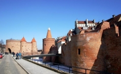
- ⊙The Barbican.
- ⊙Fountain Show.
- ⊙Arkady Kubickiego.
- ⊙Kamienne Schodki.
- ⊙View over Vistula.
- ⊙Monument to Jan Kiliński.
Noble residences
- ⊙Pałac Raczyńskich (Raczyńskich Palace), ul. Długa 7.
- ⊙Pałac Radziwiłłowej (Radziwiłł Palace), ul. Długa 26.
- ⊙Pałac pod Czterema Wiatrami (Palace under the Four Winds), ul. Długa 38/40.
- ⊙Pałac Branickich (Branickich Palace), ul. Miodowa 6.
- ⊙Pałac Paca (Pac Palace), ul. Miodowa 15.
- ⊙Pałac Borchów (Borchów Palace), ul Miodowa 17.
- ⊙Pałac Krasińskich (Krasińskich Palace), pl. Krasińskich 5.
Churches
- ⊙St. John's Cathedral (Katedra św. Jana) (Old Town). The Warsaw's cathedral was an opulent neogothic church before World War II, but following its destruction it was rebuilt in a sombre, masovian gothic style resembling what is presumed to be its original form.
- ⊙Jesuit Church (Kościół Jezuitów), ul. Świętojańska 10 (Old Town), ☎ +48 22 831 1675. From the outside it seems like a large church, but step over the threshold and you'll see a rather modest and relatively small worship hall.
- ⊙Kościół Kapucynów Przemienienia Pańskiego (Transfiguration of Jesus Capuchins Church), ul. Miodowa 13.
- ⊙Kościół Garnizonowy NMP (Virgin Mary Garrison Church), ul. Długa 13/15.
- ⊙Kościół Bazylianów (Basilians Church), ul. Miodowa 16.
Squares
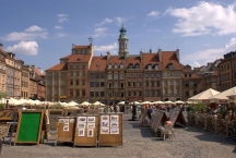
⊙ The Old Town Market Place ![]() (Rynek Starego Miasta), which dates back to the end of the 13th century, is the true heart of the Old Town, and until the end of the 18th century it was the heart of all of Warsaw. Here the representatives of guilds and merchants met in the Town Hall (built before 1429, pulled down in 1817), and fairs and the occasional execution were held. The houses around it represented the Gothic style until the great fire of 1607, after which they were rebuilt in late-Renaissance style.
(Rynek Starego Miasta), which dates back to the end of the 13th century, is the true heart of the Old Town, and until the end of the 18th century it was the heart of all of Warsaw. Here the representatives of guilds and merchants met in the Town Hall (built before 1429, pulled down in 1817), and fairs and the occasional execution were held. The houses around it represented the Gothic style until the great fire of 1607, after which they were rebuilt in late-Renaissance style.
⊙Castle Square ![]() (plac Zamkowy) is a visitor's first view of the reconstructed Old Town, when approaching from the more modern center of Warsaw. It is an impressive sight, dominated by Zygmunt's Column
(plac Zamkowy) is a visitor's first view of the reconstructed Old Town, when approaching from the more modern center of Warsaw. It is an impressive sight, dominated by Zygmunt's Column ![]() , which towers above the beautiful Old Town houses. Enclosed between the Old Town and the Royal Castle, Castle Square is steeped in history. Here was the gateway leading into the city called the Kraków Gate (Brama Krakowska). It was developed in the 14th century and continued to be a defensive area for the kings. The square was in its glory in the 17th century when Warsaw became the country's capital and it was here in 1644 that King Władysław IV erected the column to glorify his father Sigismund III Vasa, who is best known for moving the capital of Poland from Kraków to Warsaw.
, which towers above the beautiful Old Town houses. Enclosed between the Old Town and the Royal Castle, Castle Square is steeped in history. Here was the gateway leading into the city called the Kraków Gate (Brama Krakowska). It was developed in the 14th century and continued to be a defensive area for the kings. The square was in its glory in the 17th century when Warsaw became the country's capital and it was here in 1644 that King Władysław IV erected the column to glorify his father Sigismund III Vasa, who is best known for moving the capital of Poland from Kraków to Warsaw.
⊙ Canon Square (plac Kanonia), behind ⊙St. John's Cathedral ![]() , is a small triangular square. Its name comes from the 17th-century tenement houses which belonged to the canons of the Warsaw chapter. Some of these canons were quite famous, like Stanisław Staszic who was the co-author of the Constitution of May 3, 1791. Formerly, it was a parochial cemetery, of which there remains a Baroque figure of Our Lady from the 18th century. In the middle of the square, is the bronze bell of Warsaw, that Grand Crown Treasurer Jan Mikołaj Daniłowicz, founded in 1646 for the Jesuit Church in Jarosław. The bell was cast in 1646 by Daniel Tym - the designer of the Zygmunt's Column. Where the Canon Square meets the Royal Square is a covered passage built for Queen Anna Jagiellon in the late 16th century and extended in the 1620s after Michał Piekarski's failed 1620 attempt to assassinate King Sigismund III Vasa as he was entering the Cathedral. Also the thinnest house in Warsaw is located there.
, is a small triangular square. Its name comes from the 17th-century tenement houses which belonged to the canons of the Warsaw chapter. Some of these canons were quite famous, like Stanisław Staszic who was the co-author of the Constitution of May 3, 1791. Formerly, it was a parochial cemetery, of which there remains a Baroque figure of Our Lady from the 18th century. In the middle of the square, is the bronze bell of Warsaw, that Grand Crown Treasurer Jan Mikołaj Daniłowicz, founded in 1646 for the Jesuit Church in Jarosław. The bell was cast in 1646 by Daniel Tym - the designer of the Zygmunt's Column. Where the Canon Square meets the Royal Square is a covered passage built for Queen Anna Jagiellon in the late 16th century and extended in the 1620s after Michał Piekarski's failed 1620 attempt to assassinate King Sigismund III Vasa as he was entering the Cathedral. Also the thinnest house in Warsaw is located there.
Museums
- ⊙Warsaw History Museum (Muzeum Historyczne Warszawy), Rynek Starego Miasta 20.
- ⊙Muzeum Literatury im. Adama Mickiewicza, Rynek Starego Miasta 28/42 (Old Town Market).
- ⊙Asia-Pacific Museum (Muzeum Azji i Pacyfiku), ul. Freta 5, ☎ +48 22 635 2811.
- ⊙Marie Curie Museum (Muzeum Marii Curie-Skłodowskiej), ul. Freta 16 (In Warsaw's New Town), ☎ +48 22 831 8092.
Information about copyright | |
|---|---|
Rights characteristic / license | by-sa: CREATIVE COMMONS Attribution-ShareAlike |
Link to the description of the license | |
Input taken over from: |
|
taken over / edited on | 01 Dec 2015 - 02 Oct 2016
|
taken over / edited by |
|
0 km
2,0 km
117 m
11 km
0,4 km
Information about copyright | |
|---|---|
Rights owner | https://commons.wikimedia.org/w/index.php?title=User:Bartosz_MORĄG |
Rights characteristic / license | by-sa: CREATIVE COMMONS Attribution-ShareAlike |
Link to the description of the license | |
Image taken over from | https://commons.wikimedia.org/wiki/File:Pałac_w_Wilanowie_(1).JPG |
Image has been uploaded | by biroto-Redaktion on 02 Dec 2015
|
Information about copyright | |
|---|---|
Rights owner | |
Rights characteristic / license | cc0: Public Domain no Rights reserved |
Link to the description of the license | |
Image taken over from | |
Image has been uploaded | by biroto-Redaktion on 02 Dec 2015
|
Information about copyright | |
|---|---|
Rights owner | https://commons.wikimedia.org/w/index.php?title=User:DocentX |
Rights characteristic / license | by-sa: CREATIVE COMMONS Attribution-ShareAlike |
Link to the description of the license | |
Image taken over from | |
Image has been uploaded | by biroto-Redaktion on 02 Dec 2015
|
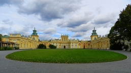
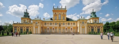
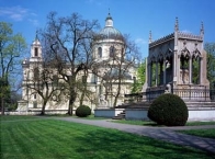
Wilanów Palace or Wilanowski Palace (Polish: pałac w Wilanowie, Polish pronunciation: [ˈpawat͡s vvilaˈnɔvjɛ]) is a royal palace located in the Wilanów district ![]() , Warsaw
, Warsaw ![]() . Wilanów Palace survived Poland's partitions and both World Wars, and so serves as a reminder of the culture of the Polish state as it was before the misfortunes of the 18th century.
. Wilanów Palace survived Poland's partitions and both World Wars, and so serves as a reminder of the culture of the Polish state as it was before the misfortunes of the 18th century.
It is one of Poland's most important monuments. The Palace's museum ![]() , established in 1805, is a repository of the country's royal and artistic heritage. The palace and park in Wilanów hosts cultural events and concerts, including Summer Royal Concerts in the Rose Garden and the International Summer Early Music Academy.
, established in 1805, is a repository of the country's royal and artistic heritage. The palace and park in Wilanów hosts cultural events and concerts, including Summer Royal Concerts in the Rose Garden and the International Summer Early Music Academy.
Information about copyright | |
|---|---|
Rights characteristic / license | by-sa: CREATIVE COMMONS Attribution-ShareAlike |
Link to the description of the license | |
Input taken over from: |
Wikipedia contributors, 'Wilanów Palace', Wikipedia, The Free Encyclopedia, 10 October 2015, 22:53 UTC, <https://en.wikipedia.org/w/index.php?title=Wilan%C3%B3w_Palace&oldid=685119237> [accessed 1 December 2015] |
taken over / edited on | 02 Dec 2015
|
taken over / edited by |
|
246 km
4,9 km
260 m
![]()