
Moselle Cycle Route
Actions
![]()
Please wait - map data are loading
Added on 08 Dec 2011,
last edited by biroto-Redaktion on 28 May 2021
Actions
Cycle route metrics
Total distance in km
519
Information about rights to the gps-track data | |
|---|---|
Rights owner | OpenStreetMap and Contributors + biroto-Redaktion (biroto.eu) |
Rights characteristic / license | Contains information from OpenStreetMap, which is made available here under the Open Database License(ODbL) |
Link to the description of the license | |
GPX file taken from | |
GPX file uploaded | by biroto-Redaktion on 28 May 2021
|
Track points in total
6.681
Track points per km (avg)
13
Start/endpoint
Start location
Bussang, Grand Est, FR (601 m NHN)
End location
Koblenz, Rheinland-Pfalz, DE (64 m NHN)
Character
Der Mosel-Radweg ist eine internationale Radwanderroute entlang der Mosel, auch unter dem Namen Velo Tour Moselle bekannt.
Die Beschilderung des französischen Teils beginnt in Metz ![]() . Der deutsche Teil startet in Perl
. Der deutsche Teil startet in Perl ![]() und führt bis zur Moselmündung in den Rhein am Deutschen Eck in Koblenz
und führt bis zur Moselmündung in den Rhein am Deutschen Eck in Koblenz ![]() . Die Gesamtlänge ab Metz beträgt 311 km, die des deutschen Teils 239 km. Die Radwanderroute ist ein typischer Flussradweg ohne nennenswerte Steigungen. Der deutsche Teil wird über asphaltierte Radwege, entweder auf eigener Trasse oder straßenbegleitend geführt und ist deshalb auch für Familien geeignet.
. Die Gesamtlänge ab Metz beträgt 311 km, die des deutschen Teils 239 km. Die Radwanderroute ist ein typischer Flussradweg ohne nennenswerte Steigungen. Der deutsche Teil wird über asphaltierte Radwege, entweder auf eigener Trasse oder straßenbegleitend geführt und ist deshalb auch für Familien geeignet.
Information about copyright | |
|---|---|
Rights characteristic / license | by-sa: CREATIVE COMMONS Attribution-ShareAlike |
Link to the description of the license | |
Input taken over from: |
Seite „Mosel-Radweg“. In: Wikipedia, Die freie Enzyklopädie. Bearbeitungsstand: 28. März 2013, 11:03 UTC. URL: http://de.wikipedia.org/w/index.php?title=Mosel-Radweg&oldid=116072565 |
taken over / edited on | 03 Apr 2013 - 28 May 2021
|
taken over / edited by |
|
Landscape
Die Mosel entspringt auf 735 m ü. NN in den Vogesen an der Westseite des Col de Bussang ![]() . Von hier fließt sie mit erheblichen Gefälle bis Neuves-Maisons
. Von hier fließt sie mit erheblichen Gefälle bis Neuves-Maisons ![]() , ab wo sie durch 14 Staustufen schiffbar gemacht wurde, bis sie am Deutschen Eck in Koblenz
, ab wo sie durch 14 Staustufen schiffbar gemacht wurde, bis sie am Deutschen Eck in Koblenz ![]() in den Rhein mündet. Dabei hat sie durch viele Schleifen im unteren Bereich einen Weg von 544 km zurückzulegen.
in den Rhein mündet. Dabei hat sie durch viele Schleifen im unteren Bereich einen Weg von 544 km zurückzulegen.
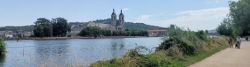
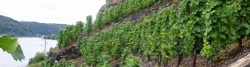
In Lothringen erstreckt sich der landschaftlich attraktive Teil des Mosel-Radweges von der Quelle bis Épinal ![]() . Danach ist die Landschaft am Mosellauf wieder ab der deutschen Grenze bei Perl
. Danach ist die Landschaft am Mosellauf wieder ab der deutschen Grenze bei Perl ![]() von erhöhtem Reiz. Von hier zieht sich der Weinbau fast durchgehend bis zur Mündung. Noch niedrig sind die Uferberge von der deutschen Grenze bis Trier
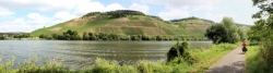
von erhöhtem Reiz. Von hier zieht sich der Weinbau fast durchgehend bis zur Mündung. Noch niedrig sind die Uferberge von der deutschen Grenze bis Trier ![]() , danach werden sie höher und die Mosel mäandert mit ihren typischen Schleifen durch das Weinkulturgebiet bis Briedel
, danach werden sie höher und die Mosel mäandert mit ihren typischen Schleifen durch das Weinkulturgebiet bis Briedel ![]() . Weinbergterrassen prägen hier das Bild und die Mosel teilt die beiden Mittelgebirge Eifel und Hunsrück. Trier, als eine der ältesten Städte Deutschlands, bietet 2000 Jahre Geschichte mit sehenswerten Bauten aus der Römerzeit. Die Winzerdörfer und Städtchen beiderseits der Mosel bieten viele Sehenswürdigkeiten, wie etwa das Römer-Weinschiff
. Weinbergterrassen prägen hier das Bild und die Mosel teilt die beiden Mittelgebirge Eifel und Hunsrück. Trier, als eine der ältesten Städte Deutschlands, bietet 2000 Jahre Geschichte mit sehenswerten Bauten aus der Römerzeit. Die Winzerdörfer und Städtchen beiderseits der Mosel bieten viele Sehenswürdigkeiten, wie etwa das Römer-Weinschiff ![]() in Neumagen-Dhron
in Neumagen-Dhron ![]() , die römischen Kelteranlagen an der Mittelmosel, das mittelalterliche Stadtbild von Bernkastel-Kues
, die römischen Kelteranlagen an der Mittelmosel, das mittelalterliche Stadtbild von Bernkastel-Kues ![]() , den Jugendstil in Traben-Trarbach
, den Jugendstil in Traben-Trarbach ![]() oder das moselfränkische Fachwerk in Kröv
oder das moselfränkische Fachwerk in Kröv ![]() . Zwischen Zell
. Zwischen Zell ![]() und Koblenz säumen eine Reihe von Burgen den Mosellauf, wie die Marienburg
und Koblenz säumen eine Reihe von Burgen den Mosellauf, wie die Marienburg ![]() im Zeller Land, die Reichsburg
im Zeller Land, die Reichsburg ![]() in Cochem
in Cochem ![]() , über die Burg Eltz
, über die Burg Eltz ![]() auf dem Maifeld bis zur Burg Thurant
auf dem Maifeld bis zur Burg Thurant ![]() an der Untermosel bei Kobern-Gondorf
an der Untermosel bei Kobern-Gondorf ![]() . Schließlich durchfließt die Mosel die Stadt Koblenz
. Schließlich durchfließt die Mosel die Stadt Koblenz ![]() , um am Deutschen Eck in den Rhein zu münden.
, um am Deutschen Eck in den Rhein zu münden.
Information about copyright | |
|---|---|
Rights characteristic / license | by-sa: CREATIVE COMMONS Attribution-ShareAlike |
Link to the description of the license | |
Input taken over from: |
Seite „Mosel-Radweg“. In: Wikipedia, Die freie Enzyklopädie. Bearbeitungsstand: 28. März 2013, 11:03 UTC. URL: http://de.wikipedia.org/w/index.php?title=Mosel-Radweg&oldid=116072565 |
taken over / edited on | 03 Apr 2013 - 28 May 2021
|
taken over / edited by |
|
Signposting
in Deutschland |
|

Sources of information
Books/maps:
- Cicerone Guides: The Moselle Cycle Route: From the Source to the Rhine at Koblenz
- Esterbauer bikeline: Moselle River Trail. From Metz to the Rhine, 1:50.000, 310 km
Travel reports about cycle tours
Information about copyright | |
|---|---|
Rights owner | |
Rights characteristic / license | by-sa: CREATIVE COMMONS Attribution-ShareAlike |
Link to the description of the license | |
Image has been uploaded | by ThimbleU on 24 Aug 2023
|
08 Jul 2023
71 km
A stage of the tour »Aachen - Vennbahn - Mosel - Saar - Mosel - Erft - Solingen« of user ThimbleU

Information about copyright | |
|---|---|
Rights owner | |
Rights characteristic / license | by-sa: CREATIVE COMMONS Attribution-ShareAlike |
Link to the description of the license | |
Image has been uploaded | by ThimbleU on 24 Aug 2023
|
07 Jul 2023
74 km
A stage of the tour »Aachen - Vennbahn - Mosel - Saar - Mosel - Erft - Solingen« of user ThimbleU
Information about copyright | |
|---|---|
Rights owner | |
Rights characteristic / license | by-sa: CREATIVE COMMONS Attribution-ShareAlike |
Link to the description of the license | |
Image has been uploaded | by ThimbleU on 27 Aug 2023
|
14 Jul 2023
43 km
A stage of the tour »Aachen - Vennbahn - Mosel - Saar - Mosel - Erft - Solingen« of user ThimbleU
Information about copyright | |
|---|---|
Rights owner | |
Rights characteristic / license | by-sa: CREATIVE COMMONS Attribution-ShareAlike |
Link to the description of the license | |
Image has been uploaded | by ThimbleU on 28 Aug 2023
|
16 Jul 2023
64 km
A stage of the tour »Aachen - Vennbahn - Mosel - Saar - Mosel - Erft - Solingen« of user ThimbleU
04 Jul 2007
114 km
A stage of the tour »Euskirchen - Kyll - Moselle - Lahn - Siegen« of user ThimbleU
Beds4Cyclists, worth visiting and infrastructure
Name and address
Latitude / Longitude
Phone
Fax
Mobile
Type of accommodation
Rating for cyclists
Route km
Dist. to route
Elevation
9 km
3,5 km
515 m
FR-88160 Paroisse Bienheureux-Frédéric-Ozanam
Tourist information
11 km
0,7 km
483 m
32 km
0,4 km
396 m
32 km
0,3 km
383 m
33 km
0,4 km
409 m
![]()