
Cycle Tour Kreuz und Quer durch die Schweiz
Travel report: Nord Süd-Route 3 mit Ascona, Rhone-Route 1 und Mittelland-Route 5
Actions
![]()
Please wait - map data are loading
Added on 07 Jan 2015,
last edited by Tandemteam-Traudel_und_Dieter on 06 Feb 2015
Actions
Cycle route metrics
planned
ridden
Total distance in km
1.169
1.028
Cumulative elevation gain in m
23.352
20.561
Avg. slope uphill in %
2,00
2,00
Cumulative elevation loss in m
23.216
21.651
Total cycling hours
-
66,2
Avg. pace in km/h
-
15,5
Information about rights to the gps-track data | |
|---|---|
Rights owner | |
Rights characteristic / license | by-sa: CREATIVE COMMONS Attribution-ShareAlike |
Link to the description of the license | |
GPX file uploaded | by Tandemteam-Traudel_und_Dieter on 22 Jan 2015
|
Track points in total
6.678
6.920
Track points per km (avg)
6
7
Start/endpoint
Start location
Basel, Basel-City, CH (265 m NHN)
End location
Konstanz, Baden-Württemberg, DE (401 m NHN)
Character
Information about copyright | |
|---|---|
Rights characteristic / license | by-sa: CREATIVE COMMONS Attribution-ShareAlike |
Link to the description of the license | |
taken over / edited on | 08 Jan 2015 - 14 Jan 2015
|
taken over / edited by |
|
Landscape
Information about copyright | |
|---|---|
Rights characteristic / license | by-sa: CREATIVE COMMONS Attribution-ShareAlike |
Link to the description of the license | |
taken over / edited on | 08 Jan 2015
|
taken over / edited by |
|
Travel to and from ...
Mit Nahverkehrszügen mit mehreren Umstiegen
Sources of information
Schweizmobil
Es gibt Tourenbeschreibungen im Werd Verlag "Veloland Schweiz"
Remarks
In der Schweiz gibt es 9 nationale Routen die sehr gut ausgeschildert sind!
Wir hatten eine Karte der Schweizer Campingplätze im Maßstab 1 : 600 000, und einen Führer der Nord-Süd-Route 3 vom Werd Verlag.
Stages
Information about copyright | |
|---|---|
Rights owner | |
Rights characteristic / license | © all rights reserved. |
Image has been uploaded | by Tandemteam-Traudel_und_Dieter on 23 Jan 2015
|
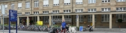
Anreise: Fulda nach Basel
Information about copyright | |
|---|---|
Rights owner | |
Rights characteristic / license | © all rights reserved. |
Image has been uploaded | by Tandemteam-Traudel_und_Dieter on 23 Jan 2015
|
98 km
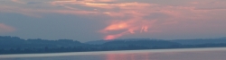
Basel nach Sempach
Information about copyright | |
|---|---|
Rights owner | |
Rights characteristic / license | © all rights reserved. |
Image has been uploaded | by Tandemteam-Traudel_und_Dieter on 23 Jan 2015
|
73 km
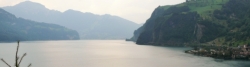
Sempach nach Flüelen
Information about copyright | |
|---|---|
Rights owner | |
Rights characteristic / license | © all rights reserved. |
Image has been uploaded | by Tandemteam-Traudel_und_Dieter on 24 Jan 2015
|
45 km
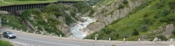
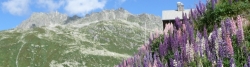
Flüelen nach Hospental
Information about copyright | |
|---|---|
Rights owner | |
Rights characteristic / license | © all rights reserved. |
Image has been uploaded | by Tandemteam-Traudel_und_Dieter on 24 Jan 2015
|
84 km
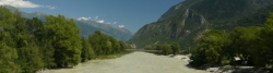
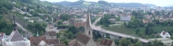
Hospental nach Bellinzona
Information about copyright | |
|---|---|
Rights owner | |
Rights characteristic / license | © all rights reserved. |
Image has been uploaded | by Tandemteam-Traudel_und_Dieter on 24 Jan 2015
|
61 km
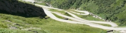
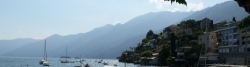
Bellinzona nach Ascona und zurück
Information about copyright | |
|---|---|
Rights owner | |
Rights characteristic / license | © all rights reserved. |
Image has been uploaded | by Tandemteam-Traudel_und_Dieter on 24 Jan 2015
|
76 km
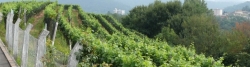
Bellinzona nach Chiasso
Information about copyright | |
|---|---|
Rights owner | |
Rights characteristic / license | © all rights reserved. |
Image has been uploaded | by Tandemteam-Traudel_und_Dieter on 24 Jan 2015
|
64 km
Hospental nach Fiesch
Information about copyright | |
|---|---|
Rights owner | |
Rights characteristic / license | © all rights reserved. |
Image has been uploaded | by Tandemteam-Traudel_und_Dieter on 24 Jan 2015
|
102 km
Fiesch nach Saillon
Information about copyright | |
|---|---|
Rights owner | |
Rights characteristic / license | © all rights reserved. |
Image has been uploaded | by Tandemteam-Traudel_und_Dieter on 24 Jan 2015
|
101 km
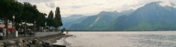
Saillon nach Morges
Information about copyright | |
|---|---|
Rights owner | |
Rights characteristic / license | © all rights reserved. |
Image has been uploaded | by Tandemteam-Traudel_und_Dieter on 24 Jan 2015
|
73 km
Morges nach Estavayer-le-Lac
Information about copyright | |
|---|---|
Rights owner | |
Rights characteristic / license | © all rights reserved. |
Image has been uploaded | by Tandemteam-Traudel_und_Dieter on 24 Jan 2015
|
95 km
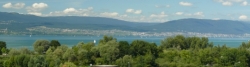
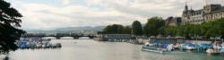
Estavayer-le-Lac nach Solothurn
Information about copyright | |
|---|---|
Rights owner | |
Rights characteristic / license | © all rights reserved. |
Image has been uploaded | by Tandemteam-Traudel_und_Dieter on 25 Jan 2015
|
98 km
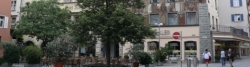
Solothurn nach Baden
Information about copyright | |
|---|---|
Rights owner | |
Rights characteristic / license | © all rights reserved. |
Image has been uploaded | by Tandemteam-Traudel_und_Dieter on 25 Jan 2015
|
56 km
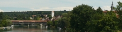
Baden nach Winterthur
Information about copyright | |
|---|---|
Rights owner | |
Rights characteristic / license | © all rights reserved. |
Image has been uploaded | by Tandemteam-Traudel_und_Dieter on 25 Jan 2015
|
2 km
Kreuzlingen nach Konstanz und Rückfahrt
Beds4Cyclists, worth visiting and infrastructure
Name and address
Latitude / Longitude
Phone
Fax
Mobile
Type of accommodation
Rating for cyclists
Route km
Dist. to route
Elevation
0 km
2,8 km
284 m
0 km
1,2 km
283 m
Hours of opening
Mo-Fr 08:00-18:00
Sa 09:00-17:00
Su 09:00-15:00
Languages spoken:
Deutsch ▪ English
0 km
1,0 km
289 m
0 km
1,1 km
291 m
0 km
1,5 km
286 m
![]()