
Cycle Tour Aachen - Vennbahn - Mosel - Saar - Mosel - Erft - Solingen
Tag 14: Mülheim - Daun
![]()
Please wait - map data are loading
Added on 19 Jul 2023
last edited by ThimbleU on 04 Oct 2023
Cycle route metrics
ridden
Total distance in km
56
Cumulative elevation gain in m
601
Avg. slope uphill in %
1,07
Cumulative elevation loss in m
269
Total cycling hours
3,7
Avg. pace in km/h
15,1
Min. height
102
Max. height
462
Information about rights to the gps-track data | |
|---|---|
Rights owner | |
Rights characteristic / license | cc0: Public Domain no Rights reserved |
Link to the description of the license | |
GPX file uploaded | by ThimbleU on 17 Jul 2023
|
Track points in total
973
Track points per km (avg)
17
Start/endpoint
Start location
Mülheim an der Mosel, RP, DE (105 m NHN)
End location
Daun, RP, DE (437 m NHN)
ridden on
17 Jul 2023
Weather
Bewölkt, überwiegend windstill, teilweise Böen, trocken. 20 bis 24°C.
Accommodation
Schlosshotel Kurfürstliches Amtshaus
Burgfriedstraße 28
DE-54550 Daun
Signposting
Logo des Maare-Mosel-Radweges. Zwischenwegweisung mit allgemeinem Radwegweisungsschild (grün), teilweise Bodenwegweisung. Für die Navigation ausreichend! |
|
|


Travel report
Information about copyright | |
|---|---|
Rights owner | |
Rights characteristic / license | by-sa: CREATIVE COMMONS Attribution-ShareAlike |
Link to the description of the license | |
Image has been uploaded | by ThimbleU on 28 Aug 2023
|
Information about copyright | |
|---|---|
Rights owner | |
Rights characteristic / license | by-sa: CREATIVE COMMONS Attribution-ShareAlike |
Link to the description of the license | |
Image has been uploaded | by ThimbleU on 28 Aug 2023
|
Information about copyright | |
|---|---|
Rights owner | |
Rights characteristic / license | by-sa: CREATIVE COMMONS Attribution-ShareAlike |
Link to the description of the license | |
Image has been uploaded | by ThimbleU on 28 Aug 2023
|
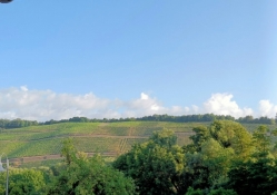
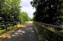
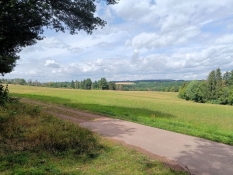
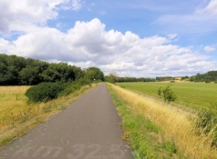
Von Mülheim aus queren wir über die Moselbrücke an das linke Ufer. Dann radeln wir auf der ehemaligen Bahntrasse das Liesertal hinauf. Bis Siebenborn ist der Weg beidseits buschbestanden. Klosterhof und Klostermühle der ehemaligen Propstei der Abtei Himmerod aus dem 16. Jahrhundert bieten einen hübschen Anblick. In waldigem Gelände mit gelegentlichen Wiesen fahren wir die leichte Steigung hinauf. Erst vor Platten wird die Landschaft offener. Hinter Patten wird die ehemalige Bahntrasse zur Umfahrung der neuen B50 unterbrochen. Ab Wengerohr verläuft die Route auf Nebenstraßen bzw. neben Hauptstraßen.
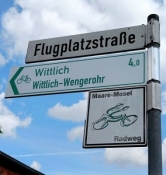
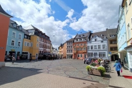
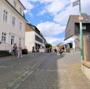
In Wittlich machen wir einen Abstecher in den alten Stadtkern. Um den Markt einige schöne Hausfassaden.
Information about copyright | |
|---|---|
Rights characteristic / license | by-sa: CREATIVE COMMONS Attribution-ShareAlike |
Link to the description of the license | |
taken over / edited on | 28 Aug 2023 - 02 Oct 2023
|
taken over / edited by |
|
Information about copyright | |
|---|---|
Rights owner | |
Rights characteristic / license | by-sa: CREATIVE COMMONS Attribution-ShareAlike |
Link to the description of the license | |
Image has been uploaded | by ThimbleU on 28 Aug 2023
|
Information about copyright | |
|---|---|
Rights owner | |
Rights characteristic / license | by-sa: CREATIVE COMMONS Attribution-ShareAlike |
Link to the description of the license | |
Image has been uploaded | by ThimbleU on 28 Aug 2023
|
Information about copyright | |
|---|---|
Rights owner | |
Rights characteristic / license | by-sa: CREATIVE COMMONS Attribution-ShareAlike |
Link to the description of the license | |
Image has been uploaded | by ThimbleU on 28 Aug 2023
|
Information about copyright | |
|---|---|
Rights owner | |
Rights characteristic / license | by-sa: CREATIVE COMMONS Attribution-ShareAlike |
Link to the description of the license | |
Image has been uploaded | by ThimbleU on 28 Aug 2023
|
Information about copyright | |
|---|---|
Rights owner | |
Rights characteristic / license | by-sa: CREATIVE COMMONS Attribution-ShareAlike |
Link to the description of the license | |
Image has been uploaded | by ThimbleU on 28 Aug 2023
|
Information about copyright | |
|---|---|
Rights owner | |
Rights characteristic / license | by-sa: CREATIVE COMMONS Attribution-ShareAlike |
Link to the description of the license | |
Image has been uploaded | by ThimbleU on 28 Aug 2023
|
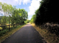
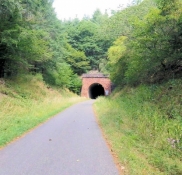
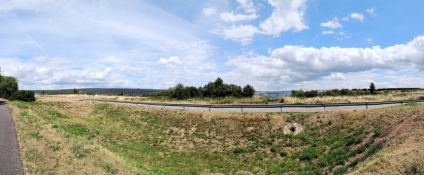
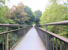
Für die Weiterfahrt müssen wir wieder zurück zur Anhöhe. Direkt an der Burgstraße radeln wir wieder auf die Bahntrasse, die, jetzt mit merklich mehr Steigung, stadtauswärts führt. Vorbei an einem letzten Weinberg führt sie in den Wald. Im weiteren Aufstieg umfahren wir eine Brücke, durchradeln zwei Tunnel und radeln 31 Meter über dem Talboden über die 100 Meter lange Pleiner Brücke. Weiter kommen wir durch den fast 600 Meter langen Pleiner Tunnel. In Hasborn haben wir dann die Steigung im Wesentlichen geschafft.
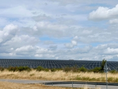
Bei Niederöfflingen kommen wir an zwei großen Solarfeldern vorbei. Es ist die größte interkommunale Photovoltaikanlage von Rheinland-Pfalz mit etwa 40 Hektar Ausdehnung.
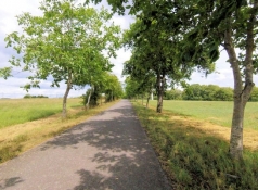
Wir sind jetzt "oben" angekommen und Abschnitte mit Ausblick weit über die Hügel der Vulkaneifel wechseln mit Abschnitten zwischen Büschen und Bäumen. In Pantenburg finden wir einen geeigneten Rastplatz mit Tischen und Bänken für die Mittagsrast.
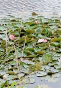
Von hier aus haben wir leichtes Gefälle bis Gillenfeld. Auf halbem Weg zwischen Eckfeld und Gillenfeld machen wir einen kurzen Abstecher zum Holzmaar. Ein fast runder See umgeben von Wald.
Information about copyright | |
|---|---|
Rights characteristic / license | by-sa: CREATIVE COMMONS Attribution-ShareAlike |
Link to the description of the license | |
taken over / edited on | 28 Aug 2023 - 02 Oct 2023
|
taken over / edited by |
|
Information about copyright | |
|---|---|
Rights owner | |
Rights characteristic / license | by-sa: CREATIVE COMMONS Attribution-ShareAlike |
Link to the description of the license | |
Image has been uploaded | by ThimbleU on 28 Aug 2023
|
Information about copyright | |
|---|---|
Rights owner | |
Rights characteristic / license | by-sa: CREATIVE COMMONS Attribution-ShareAlike |
Link to the description of the license | |
Image has been uploaded | by ThimbleU on 28 Aug 2023
|
Information about copyright | |
|---|---|
Rights owner | |
Rights characteristic / license | by-sa: CREATIVE COMMONS Attribution-ShareAlike |
Link to the description of the license | |
Image has been uploaded | by ThimbleU on 28 Aug 2023
|

Information about copyright | |
|---|---|
Rights owner | |
Rights characteristic / license | by-sa: CREATIVE COMMONS Attribution-ShareAlike |
Link to the description of the license | |
Image has been uploaded | by ThimbleU on 28 Aug 2023
|
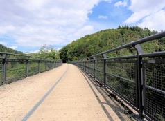
In Schalkenmehren war ebenfalls ein Abstecher zum Maar geplant. Wir verzichten und radeln weiter. Es gilt noch einmal Höhenmeter zu erklimmen, bis der 560 m lange Bahntunnel „Großes Schlitzohr“ erreicht ist. Danach rollen wir abwärts nach Daun. Vom Dauner Viadukt ist es noch ein halber Kilometer bis zum Bahnhof.
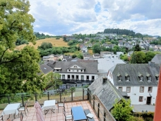
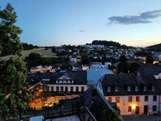
Hier müssen wir uns erst orientieren, wie wir zu unserem Hotel auf der ehemaligen Dauner Burg kommen. Sehen können wir die Gebäude schon und bald ist auch der Weg klar. Über eine schmale Brücke gelangen wir auf die andere Talseite und umrunden dann den Bergkegel zu drei Viertel. Dabei müssen wir nochmals kräftig bergauf, insbesondere die letzen 100 Meter haben es in sich.
Unsere Fahrräder kommen in der ehemaligen Zehntscheune unter. Und wir haben ein schöens und ruhiges Zimmer mit Blick über Daun.
Information about copyright | |
|---|---|
Rights characteristic / license | by-sa: CREATIVE COMMONS Attribution-ShareAlike |
Link to the description of the license | |
taken over / edited on | 28 Aug 2023 - 02 Oct 2023
|
taken over / edited by |
|
Information about copyright | |
|---|---|
Rights owner | |
Rights characteristic / license | by-sa: CREATIVE COMMONS Attribution-ShareAlike |
Link to the description of the license | |
Image has been uploaded | by ThimbleU on 28 Aug 2023
|
Information about copyright | |
|---|---|
Rights owner | |
Rights characteristic / license | by-sa: CREATIVE COMMONS Attribution-ShareAlike |
Link to the description of the license | |
Image has been uploaded | by ThimbleU on 28 Aug 2023
|
Information about copyright | |
|---|---|
Rights owner | |
Rights characteristic / license | by-sa: CREATIVE COMMONS Attribution-ShareAlike |
Link to the description of the license | |
Image has been uploaded | by ThimbleU on 28 Aug 2023
|
Information about copyright | |
|---|---|
Rights owner | |
Rights characteristic / license | by-sa: CREATIVE COMMONS Attribution-ShareAlike |
Link to the description of the license | |
Image has been uploaded | by ThimbleU on 28 Aug 2023
|
Information about copyright | |
|---|---|
Rights owner | |
Rights characteristic / license | by-sa: CREATIVE COMMONS Attribution-ShareAlike |
Link to the description of the license | |
Image has been uploaded | by ThimbleU on 28 Aug 2023
|