
Cycle Tour Aachen - Vennbahn - Mosel - Saar - Mosel - Erft - Solingen
Tag 15: Daun - Kall
![]()
Please wait - map data are loading
Added on 19 Jul 2023
last edited by ThimbleU on 04 Oct 2023
Cycle route metrics
ridden
Total distance in km
74
Cumulative elevation gain in m
882
Avg. slope uphill in %
1,19
Cumulative elevation loss in m
917
Total cycling hours
4,8
Avg. pace in km/h
15,4
Min. height
312
Max. height
568
Information about rights to the gps-track data | |
|---|---|
Rights owner | |
Rights characteristic / license | cc0: Public Domain no Rights reserved |
Link to the description of the license | |
GPX file uploaded | by ThimbleU on 03 Oct 2023
|
Track points in total
1.545
Track points per km (avg)
21
Start/endpoint
Start location
Daun, RP, DE (437 m NHN)
End location
Kall, NW, DE (402 m NHN)
ridden on
18 Jul 2023
Weather
Bedeckt bis sonnig mehrfach wechselnd, trocken, ohne Wind. 18 bis 25°C.
Accommodation
Eifel-Pension
Hüttenstraße 63a
DE-53925 Kall
Signposting
Bis Ahrort Logo des Mineralquellen-Radweges. Im Wesentlichen allgemeines Radwegweisungsschild (grün). Für die Navigation ausreichend! |
|
| |
Bis Blankenheim Logo des Ahr-Radweges. Im Wesentlichen allgemeines Radwegweisungsschild (rot), teilweise Bodenwegweisung. Für die Navigation ausreichend! |
|
|


Slope Gradient Distribution
Travel report
Information about copyright | |
|---|---|
Rights owner | |
Rights characteristic / license | by-sa: CREATIVE COMMONS Attribution-ShareAlike |
Link to the description of the license | |
Image has been uploaded | by ThimbleU on 28 Aug 2023
|
Information about copyright | |
|---|---|
Rights owner | |
Rights characteristic / license | by-sa: CREATIVE COMMONS Attribution-ShareAlike |
Link to the description of the license | |
Image has been uploaded | by ThimbleU on 28 Aug 2023
|
Information about copyright | |
|---|---|
Rights owner | |
Rights characteristic / license | by-sa: CREATIVE COMMONS Attribution-ShareAlike |
Link to the description of the license | |
Image has been uploaded | by ThimbleU on 28 Aug 2023
|
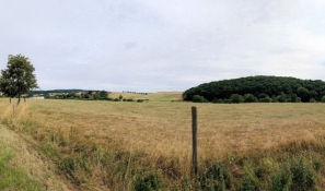
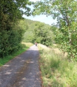
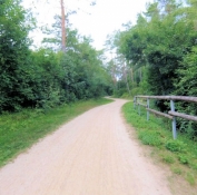
In Daun radeln wir erst einmal zum Bäcker, den wir bereits gestern Abend ausgekundschaftet hatten. Versorgt mit Brötchen und Brezeln rollen wir dann hinunter ins Tal. Ein kurzes Stück führt die Route neben der Kreisstraße her. Dann durch das Gewerbegebiet, vorbei am kleinen Ort Rengen, ins Grüne. Anfangs ist das Gelände noch offen, dann tauchen wir in den Wald ein und radeln das Tal mit 4% Steigung hinauf.
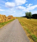
Durch Dockweiler rollen wir dann flott hinunter auf Wirtschaftswegen durch die Wiesen nach Dreis. In großem Bogen umradeln wir den weiten Talkessel. In Oberehe fahren wir steil hinauf zur Hauptstraße, um an der Burg vorbeizukommen. Es hat sich jedoch als nicht lohnend erwiesen. Das Anwesen ist hinter Büschen und Mauern verborgen. Durch das bewaldete Ahbachtal radeln wir abwärts bis zur Kreisstraße. Für 2½ Kilometer bleiben wir auf der Straße. Weiter fahren wir auf asphaltierten Wirtschafswegen im Talgrund, durch Ahütte, und ruhig weiter bis zur Mündung des Ahbaches in die Ahr.
Information about copyright | |
|---|---|
Rights characteristic / license | by-sa: CREATIVE COMMONS Attribution-ShareAlike |
Link to the description of the license | |
taken over / edited on | 28 Aug 2023 - 03 Oct 2023
|
taken over / edited by |
|
Information about copyright | |
|---|---|
Rights owner | |
Rights characteristic / license | by-sa: CREATIVE COMMONS Attribution-ShareAlike |
Link to the description of the license | |
Image has been uploaded | by ThimbleU on 28 Aug 2023
|
Information about copyright | |
|---|---|
Rights owner | |
Rights characteristic / license | by-sa: CREATIVE COMMONS Attribution-ShareAlike |
Link to the description of the license | |
Image has been uploaded | by ThimbleU on 28 Aug 2023
|
Information about copyright | |
|---|---|
Rights owner | |
Rights characteristic / license | by-sa: CREATIVE COMMONS Attribution-ShareAlike |
Link to the description of the license | |
Image has been uploaded | by ThimbleU on 28 Aug 2023
|
Information about copyright | |
|---|---|
Rights owner | |
Rights characteristic / license | by-sa: CREATIVE COMMONS Attribution-ShareAlike |
Link to the description of the license | |
Image has been uploaded | by ThimbleU on 28 Aug 2023
|
Information about copyright | |
|---|---|
Rights owner | |
Rights characteristic / license | by-sa: CREATIVE COMMONS Attribution-ShareAlike |
Link to the description of the license | |
Image has been uploaded | by ThimbleU on 28 Aug 2023
|
Information about copyright | |
|---|---|
Rights owner | |
Rights characteristic / license | by-sa: CREATIVE COMMONS Attribution-ShareAlike |
Link to the description of the license | |
Image has been uploaded | by ThimbleU on 28 Aug 2023
|
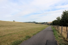
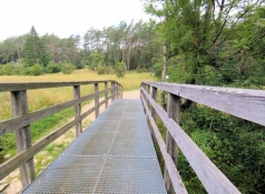
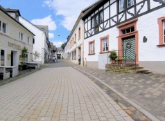
Auf der Nebenstraße erreichen wir Ahrdorf. Nahe an oder auf der ehemaligen Bahntrasse führt die Route abseits des Verkehrs das Ahrtal hinauf. Bänke am Wegesrand laden zwischendurch zur Mittagsrast ein. Bis zwei Kilometer vor Blankenheim führt uns diese gut zu fahrende Trasse. Danach folgt ein Stück auf einer Nebenstraße, den letzten ¾ Kilometer radeln wir am Rand der Bundesstraße. In Blankenheim sind wir auf der Ahrstraße geblieben und haben dadurch den alten Ortskern verpasst. Wir hätten eine Straße weiter rechts in den Ort abbiegen müssen.
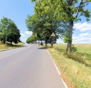
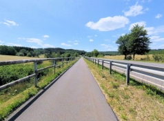
Hinter Blankenheim führt die Aachener Straße steil hinauf nach Blankenheimerdorf. Erst hinter dem "Dorf" gibt es wieder einen Radstreifen neben der Fahrbahn. Den gibt es auch neben der Bundesstraße hinunter zum Bahnhof Blankenheim. Hier beginnt der Erftradweg.
Information about copyright | |
|---|---|
Rights characteristic / license | by-sa: CREATIVE COMMONS Attribution-ShareAlike |
Link to the description of the license | |
taken over / edited on | 28 Aug 2023 - 03 Oct 2023
|
taken over / edited by |
|
Information about copyright | |
|---|---|
Rights owner | |
Rights characteristic / license | by-sa: CREATIVE COMMONS Attribution-ShareAlike |
Link to the description of the license | |
Image has been uploaded | by ThimbleU on 28 Aug 2023
|
Information about copyright | |
|---|---|
Rights owner | |
Rights characteristic / license | by-sa: CREATIVE COMMONS Attribution-ShareAlike |
Link to the description of the license | |
Image has been uploaded | by ThimbleU on 28 Aug 2023
|
Information about copyright | |
|---|---|
Rights owner | |
Rights characteristic / license | by-sa: CREATIVE COMMONS Attribution-ShareAlike |
Link to the description of the license | |
Image has been uploaded | by ThimbleU on 28 Aug 2023
|
Information about copyright | |
|---|---|
Rights owner | |
Rights characteristic / license | by-sa: CREATIVE COMMONS Attribution-ShareAlike |
Link to the description of the license | |
Image has been uploaded | by ThimbleU on 28 Aug 2023
|
Information about copyright | |
|---|---|
Rights owner | |
Rights characteristic / license | by-sa: CREATIVE COMMONS Attribution-ShareAlike |
Link to the description of the license | |
Image has been uploaded | by ThimbleU on 28 Aug 2023
|
Information about copyright | |
|---|---|
Rights owner | |
Rights characteristic / license | by-sa: CREATIVE COMMONS Attribution-ShareAlike |
Link to the description of the license | |
Image has been uploaded | by ThimbleU on 28 Aug 2023
|
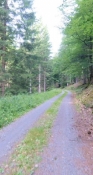
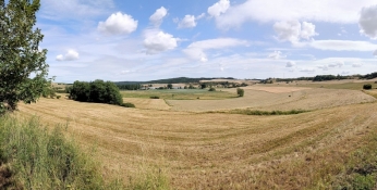
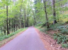
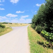
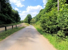
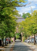
Zunächst auf gesplittetem Waldweg, später auf Asphalt radeln wir das Tal der Urft hinunter Richtung Nettersheim. Oft in Blickweite die Trasse der Eifelbahn, die zurzeit wegen der Behebung der Hochwasserschäden von 2021 außer Betrieb ist. Hinter Nettersheim fahren wir weiter durch das ruhige und idyllische Urfttal bis zum Ort Urft.
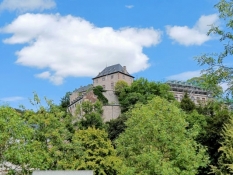
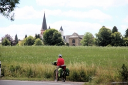
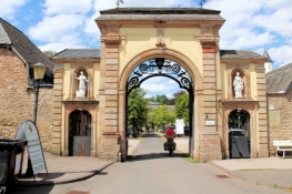
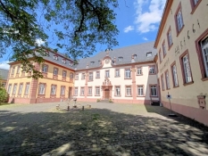
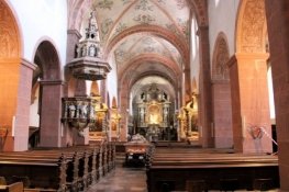
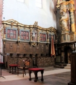
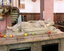
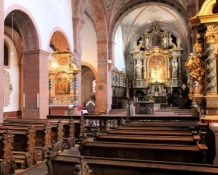
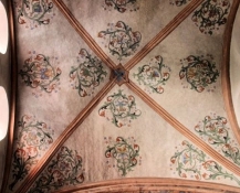
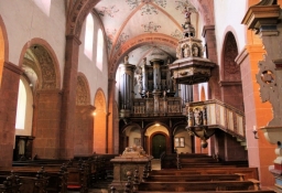
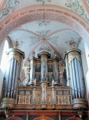
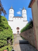
Dort verlassen wir den Erftradweg für einen Abstecher hinauf zum Kloster Steinfeld. Auf Landstraßen pedalieren wir die 110 Höhenmeter hinauf in den kleinen Ort Steinfeld, der durch die Klostergebäude dominiert wird. In den Gästehäusern des Klosters hatten wir beabsichtigt zu übernachten. Leider waren keine Zimmer frei. So bleibt es bei Cappuccino und Kuchen im Café des Klosterladens. Ein Rundgang durch das Klostergelände und die Besichtigung der Klosterkirche schließen sich an.
Information about copyright | |
|---|---|
Rights characteristic / license | by-sa: CREATIVE COMMONS Attribution-ShareAlike |
Link to the description of the license | |
taken over / edited on | 28 Aug 2023 - 03 Oct 2023
|
taken over / edited by |
|
Information about copyright | |
|---|---|
Rights owner | |
Rights characteristic / license | by-sa: CREATIVE COMMONS Attribution-ShareAlike |
Link to the description of the license | |
Image has been uploaded | by ThimbleU on 28 Aug 2023
|
Information about copyright | |
|---|---|
Rights owner | |
Rights characteristic / license | by-sa: CREATIVE COMMONS Attribution-ShareAlike |
Link to the description of the license | |
Image has been uploaded | by ThimbleU on 28 Aug 2023
|
Information about copyright | |
|---|---|
Rights owner | |
Rights characteristic / license | by-sa: CREATIVE COMMONS Attribution-ShareAlike |
Link to the description of the license | |
Image has been uploaded | by ThimbleU on 28 Aug 2023
|
Information about copyright | |
|---|---|
Rights owner | |
Rights characteristic / license | by-sa: CREATIVE COMMONS Attribution-ShareAlike |
Link to the description of the license | |
Image has been uploaded | by ThimbleU on 28 Aug 2023
|
Information about copyright | |
|---|---|
Rights owner | |
Rights characteristic / license | by-sa: CREATIVE COMMONS Attribution-ShareAlike |
Link to the description of the license | |
Image has been uploaded | by ThimbleU on 28 Aug 2023
|
Information about copyright | |
|---|---|
Rights owner | |
Rights characteristic / license | by-sa: CREATIVE COMMONS Attribution-ShareAlike |
Link to the description of the license | |
Image has been uploaded | by ThimbleU on 28 Aug 2023
|
Information about copyright | |
|---|---|
Rights owner | |
Rights characteristic / license | by-sa: CREATIVE COMMONS Attribution-ShareAlike |
Link to the description of the license | |
Image has been uploaded | by ThimbleU on 28 Aug 2023
|
Information about copyright | |
|---|---|
Rights owner | |
Rights characteristic / license | by-sa: CREATIVE COMMONS Attribution-ShareAlike |
Link to the description of the license | |
Image has been uploaded | by ThimbleU on 28 Aug 2023
|
Information about copyright | |
|---|---|
Rights owner | |
Rights characteristic / license | by-sa: CREATIVE COMMONS Attribution-ShareAlike |
Link to the description of the license | |
Image has been uploaded | by ThimbleU on 28 Aug 2023
|
Information about copyright | |
|---|---|
Rights owner | |
Rights characteristic / license | by-sa: CREATIVE COMMONS Attribution-ShareAlike |
Link to the description of the license | |
Image has been uploaded | by ThimbleU on 28 Aug 2023
|
Information about copyright | |
|---|---|
Rights owner | |
Rights characteristic / license | by-sa: CREATIVE COMMONS Attribution-ShareAlike |
Link to the description of the license | |
Image has been uploaded | by ThimbleU on 28 Aug 2023
|
Information about copyright | |
|---|---|
Rights owner | |
Rights characteristic / license | by-sa: CREATIVE COMMONS Attribution-ShareAlike |
Link to the description of the license | |
Image has been uploaded | by ThimbleU on 28 Aug 2023
|
Information about copyright | |
|---|---|
Rights owner | |
Rights characteristic / license | by-sa: CREATIVE COMMONS Attribution-ShareAlike |
Link to the description of the license | |
Image has been uploaded | by ThimbleU on 28 Aug 2023
|
Unser Track führte uns bei der Abfahrt zunächst in eine Sackgasse im Klostergelände. Vor dem verschlossenen Tor mussten wir umkehren. OpenstreetMap war hier nicht fehlerfrei. Auf Nebenstraßen und Wirtschaftswegen radeln wir hinunter und zurück zum Erftradweg. Der führt uns weiter durch das Tal der Urft bis nach Kall. Dort hatten wir unser Quartier vorgebucht. Das Einchecken erfolgte per Telefon und Code-Durchsage. Die Fahrräder mussten ein enges Treppenhaus hinunter ins Kellergeschoss und wurden dort an das Geländer gekettet. Wir hatten ein großzügiges Apartment mit Dachterrasse. Das Abendessen haben wir im Gewerbegebiet gegenüber einkaufen können.
Information about copyright | |
|---|---|
Rights characteristic / license | by-sa: CREATIVE COMMONS Attribution-ShareAlike |
Link to the description of the license | |
taken over / edited on | 03 Oct 2023
|
taken over / edited by |
|