
Loreley
Worth visiting
Added on 14 Jul 2011,
last edited by biroto-Redaktion on 01 Jan 2012
Nearby cycle routes and tours
| Route name | Type | Dist. to route |
|---|---|---|
Route | 0,7 km | |
Route | 0,7 km | |
Route | 0,7 km | |
Route | 0,7 km | |
Route | 0,7 km | |
Route | 0,7 km | |
Route | 0,7 km | |
Tour | 0,7 km | |
Tour | 0,7 km | |
Tour | 0,7 km | |
Tour | 0,7 km | |
Tour | 0,7 km | |
Tour | 0,7 km | |
Tour | 0,7 km | |
Tour | 0,7 km | |
Tour | 0,7 km |
![]()
Please wait - map data are loading
Type of sights
Natural landmark
Name and address
Loreley
∎∎∎∎∎∎∎
DE-56346 Bornich
GEO-data
Geodetic coordinates
50.14∎∎∎∎ 7.73∎∎∎∎
Elevation
182 m
Communication
Phone
+49 ∎∎∎∎ ∎∎∎ ∎
Internet
∎∎∎.∎∎∎∎∎∎∎-∎∎∎∎∎∎∎∎∎.∎∎/
∎∎∎∎@∎∎∎∎∎∎∎-∎∎∎∎∎∎∎∎∎.∎∎
Information about copyright | |
|---|---|
Rights owner | |
Rights characteristic / license | by-sa: CREATIVE COMMONS Attribution-ShareAlike |
Link to the description of the license | |
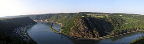
Image taken over from | commons.wikimedia.org/wiki/File:Loreley_mit_tal_von_linker_rheinseite.jpg |
Image has been uploaded | by biroto-Redaktion on 01 Jan 2012
|
Information about copyright | |
|---|---|
Rights owner | |
Rights characteristic / license | by-sa: CREATIVE COMMONS Attribution-ShareAlike |
Link to the description of the license | |
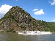
Image taken over from | commons.wikimedia.org/wiki/File:Loreley_rhine_valley_wp_d_schmidt_08_07.jpg |
Image has been uploaded | by biroto-Redaktion on 01 Jan 2012
|
Die Loreley ist ein Schieferfelsen im UNESCO-Welterbe Oberes Mittelrheintal bei Sankt Goarshausen, Rheinland-Pfalz, der sich am östlichen rechten Rheinufer als 132 Meter (193,14 m ü. NN) hoher steil aufragender Felsriegel dem Strom in den Weg stellt. Der Blick von oben auf die Rheinkurven und auf Sankt Goarshausen mit der Burg Katz ist ein Anziehungspunkt für Touristen.
Information about copyright | |
|---|---|
Rights characteristic / license | by-sa: CREATIVE COMMONS Attribution-ShareAlike |
Link to the description of the license | |
Input taken over from: |
aus Wikipedia: Loreley Stand 14.07.2011 |
taken over / edited on | 14 Jul 2011 - 01 Jan 2012
|
taken over / edited by |
|
Nearby cycle routes and tours
| Route name | Type | Dist. to route |
|---|---|---|
Route | 0,7 km | |
Route | 0,7 km | |
Route | 0,7 km | |
Route | 0,7 km | |
Route | 0,7 km | |
Route | 0,7 km | |
Route | 0,7 km | |
Tour | 0,7 km | |
Tour | 0,7 km | |
Tour | 0,7 km | |
Tour | 0,7 km | |
Tour | 0,7 km | |
Tour | 0,7 km | |
Tour | 0,7 km | |
Tour | 0,7 km | |
Tour | 0,7 km |
Added on 14 Jul 2011,
last edited by biroto-Redaktion on 01 Jan 2012