
Cycle Route EuroVelo: Rivers Route (Atlantic - Black Sea)
No. of cycle route EV6
Actions
![]()
Please wait - map data are loading
Added on 24 Nov 2011,
last edited by biroto-Redaktion on 11 Nov 2023
Actions
Cycle route metrics
Total distance in km
4.620
Information about rights to the gps-track data | |
|---|---|
Rights owner | OpenStreetMap and Contributors + biroto-Redaktion (biroto.eu) |
Rights characteristic / license | Contains information from OpenStreetMap, which is made available here under the Open Database License(ODbL) |
Link to the description of the license | |
GPX file taken from | |
GPX file uploaded | by biroto-Redaktion on 11 Nov 2023
|
Track points in total
53.287
Track points per km (avg)
12
Start/endpoint
Start location
Saint-Brevin-les-Pins, PDL, FR (5 m NHN)
End location
Constanța, RO (19 m NHN)
Sources of information
Books/maps:
- Cicerone Cycling: Cycling the River Loire: The Way of St Martin, (en)
- Olivier Kajler: Bâle à Nevers à vélo par les voies vertes, (fr)
- Esterbauer bikeline: Cycling Guide Danube Bike Trail 1: Part 1: German Danube. From Donaueschingen to Passau 1:50.000, 580 km, waterproof/water resistant, (en)
- Esterbauer bikeline: Cycline Guide Danube Bike Trail 2: Austrian Danube. From Passau to Vienna. 1:50.000, 320 km, waterproof/water resistant, (en)
- Esterbauer bikeline: Cycling Guide Danube Bike Trail - Part 3: Slovak and Hungarian Danube. From Vienna to Budapest. 1:75.000, 340 km, waterproof/water resistant, (en)
- Esterbauer bikeline: Danube Bike Trail - Part 4: From Budapest to Belgrade, 570 km, (en)
Remarks
Along the Danube this track runs, where the route alternative is available, mostly on the north bank. The track on the south bank of the Danube can be found in the Danube Cyclepath.
Travel reports about cycle tours
14 May 2014
83 km
A stage of the tour »From the Atlantic to the Upper Rhine« of user ThimbleU
15 May 2014
81 km
A stage of the tour »From the Atlantic to the Upper Rhine« of user ThimbleU
16 May 2014
89 km
A stage of the tour »From the Atlantic to the Upper Rhine« of user ThimbleU

18 May 2014
86 km
A stage of the tour »From the Atlantic to the Upper Rhine« of user ThimbleU
19 May 2014
63 km
A stage of the tour »From the Atlantic to the Upper Rhine« of user ThimbleU
20 May 2014
64 km
A stage of the tour »From the Atlantic to the Upper Rhine« of user ThimbleU
21 May 2014
81 km
A stage of the tour »From the Atlantic to the Upper Rhine« of user ThimbleU
22 May 2014
104 km
A stage of the tour »From the Atlantic to the Upper Rhine« of user ThimbleU
23 May 2014
107 km
A stage of the tour »From the Atlantic to the Upper Rhine« of user ThimbleU
24 May 2014
94 km
A stage of the tour »From the Atlantic to the Upper Rhine« of user ThimbleU
25 May 2014
98 km
A stage of the tour »From the Atlantic to the Upper Rhine« of user ThimbleU
27 May 2014
71 km
A stage of the tour »From the Atlantic to the Upper Rhine« of user ThimbleU
28 May 2014
106 km
A stage of the tour »From the Atlantic to the Upper Rhine« of user ThimbleU
29 May 2014
99 km
A stage of the tour »From the Atlantic to the Upper Rhine« of user ThimbleU
30 May 2014
58 km
A stage of the tour »From the Atlantic to the Upper Rhine« of user ThimbleU

31 May 2014
80 km
A stage of the tour »From the Atlantic to the Upper Rhine« of user ThimbleU
10 Sep 2018
72 km
A stage of the tour »Upper Danube and Neckar« of user ThimbleU
09 Sep 2018
93 km
A stage of the tour »Upper Danube and Neckar« of user ThimbleU

08 Sep 2018
30 km
A stage of the tour »Upper Danube and Neckar« of user ThimbleU
Information about copyright | |
|---|---|
Rights owner | |
Rights characteristic / license | © all rights reserved. |
Image has been uploaded | by biroto-Redaktion on 04 Nov 2011
|
20 Aug 2010
96 km
A stage of the tour »From Munich via Salzburg, Passau to Günzburg« of user ThimbleU
Information about copyright | |
|---|---|
Rights owner | |
Rights characteristic / license | © all rights reserved. |
Image has been uploaded | by biroto-Redaktion on 04 Nov 2011
|
23 Jul 2011
98 km
A stage of the tour »Passau - Linz - Salzburg - Lake Constance« of user ThimbleU
Beds4Cyclists, worth visiting and infrastructure
Name and address
Latitude / Longitude
Phone
Fax
Mobile
Type of accommodation
Rating for cyclists
Route km
Dist. to route
Elevation
0 km
3,8 km
23 m
Information about copyright | |
|---|---|
Rights owner | |
Rights characteristic / license | by-sa: CREATIVE COMMONS Attribution-ShareAlike |
Link to the description of the license | |
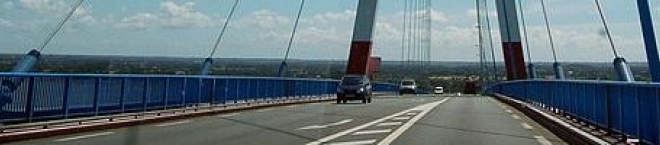
Image taken over from | commons.wikimedia.org/wiki/File:Saint-Nazaire-Bruecke_Pylon.jpg |
Image has been uploaded | by biroto-Redaktion on 16 Mar 2014
|
Bus number 317 between the station of Saint-Nazaire and Saint-Brevin.
It is possible to attach up to eight bikes to the back of the bus, and the trip takes a quarter of an hour.
Reservation recommended at least the day before ☎ +33 240 215087
The 3.3-kilometer long Saint-Nazaire bridge can be used with bicycles. However, there is no safe bike lane on the bridge and cyclists need to use a narrow side strip which has been divided in hindsight by markers from the lanes of motorized traffic.
Alternative:
Cross the Loire by taxi. Since 2015 Saint Nazaire taxi drivers have offered a new service, “20 minutes for 20€”. This is a fixed price and it’s good for 4 people and 4 bikes. The service also operates in both directions, and reservations are also required. But with the taxi service, transport is available within 20 minutes after your reservation request. The phone for taxis from Saint-Nazaire is ☎ +33 240 660262 and from Saint-Brevin ☎ +33 240 272307.
Information about copyright | |
|---|---|
Rights characteristic / license | by-sa: CREATIVE COMMONS Attribution-ShareAlike |
Link to the description of the license | |
taken over / edited on | 16 Mar 2014 - 17 Mar 2024
|
taken over / edited by |
|
0 km
0,1 km
18 m
0 km
4,8 km
7 m
0 km
3,8 km
13 m
Danièle HAMONIC
FR-44600 Saint-Nazaire
Boardinghouse / guest house
0 km
2,9 km
7 m
The team will be happy to provide all information to help you prepare your stay. Events, accomodation, restaurants… and also brochures, maps and documents about the tourist offer in Saint-Nazaire and the surrounding area.
Information about copyright | |
|---|---|
Rights characteristic / license | by-sa: CREATIVE COMMONS Attribution-ShareAlike |
Link to the description of the license | |
taken over / edited on | 16 Mar 2014
|
taken over / edited by |
|
![]()